Brought to you by Howard Sheckter
Archive for July, 2011
Monsoon II Update: Upper high now set up near the 4 corners area with good surge of monsoon moisture over SE Inyo County, moving NNW toward Mono County……
Friday July 29, 2011
Solar Scientest Geoff Sharps Northern Hemispheric 2012 winter forecast:
http://www.landscheidt.info/?q=node/224
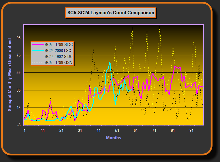
Smoothed sunspot chart must remain below 70 for another massive northern hemispheric winter to happen, according to Geoff Sharp.
http://www.landscheidt.info/images/sc5_sc24.png
Everything working out pretty well for Monsoon II.
Friday:
1. At 18z today, the upper level HT 500 low of 584DM is west of Central Baja at about 125 WEST working in tandem with Ht 500 594DM upper high along the NM/CO border, channeling SE Flow into Southeast Ca then becoming SSEerly up Eastern Ca. The upper BAJA low is forecasted to drift northward through the weekend. At 700mb, the upper flow is decisively more Southeasterly. Thunderstorms should begin to develop after 2:00pm today. RENO sounding has a valley trigger temps of 84 degrees today.
2. Current: (8:00am) Radar showing returns over SE Inyo County south into San Bernardino county then east into Nye County, NV. The direction is NNW. The visual showing strong convection with pretty high tops! PWAT over Southern Mono is between .75 now and will increase up to 1.00 by this evening. Some late afternoon thunder possible today.
3. By Saturday; PWAT is up to 1.00 to 1.25 for some wetter thunderstorms over the Sierra. The 300mb Friday 12zWRF has the Right Rear entry region approaching the Sierra for some enhancment as well. Saturdays storms will occur earlier in the day. Slow moving cells may gererate heavy rainfall and there is the possibility of some flash flooding during the afternoon.
4. By Sunday; the pattern should peak with 40 to 50knot right rear entry region of upper Jet at 250mb over the sierra (divergence aloft) along with PWAT of about 1.25+ over the area bringing the possibility of some locally heavy showers in the afternoon and evening hours. Again, Strong storms in the PM may generate heavy rainfall.
5. Drying trend to begin Monday with still a good chance of thunder…then warmer and dryer Tuesday with only a slight chance….then dry and warm Wednesday through the end of the week.
6. Next Week; The longer range models show an amplified upper pattern at high latitudes. A positive Ht 500 anomaly is over Greenland while a negative HT 500 anomaly is over Alaska. This is the signal of the Summertime negative phase Arctic oscillation (AO) and the negative phase of the North Atlantic Oscillation (NAO). This teleconnection favors troffing along the west coast and cooler then normal temps for our Sierra later next week and into the following week.
The Dweeber………….:-)
————————————————-
Reference Glossary of Weather Terms
Disclaimer: I have been a hobbyist meteorologist for over 30 years here in the Mammoth area and I do this for my personal enjoyment. The National Weather Service saves lives every day . . . I do not. When making important planning decisions please use information provided by the National Weather Service as they are the most knowledgeable and accurate information source available today.


