Brought to you by Howard Sheckter
A Gradual Pattern Change….1st to Cold and showery….then possibly to wet, 4 week of February and beyond…
Wednesday February 8, 2012
Mammoth Mt picked up about in inch from yesterdays wimpy system. It split and headed south down the Baja Coast. The 3 day period beginning with today looks dry. However, some signs showing up for some snow showers this weekend as a tweek in the pattern begins to take shape that will bring colder weather with an increasing chance of some light to even possibly moderate snowfall for Mammoth Lakes next week.
Meteorology:
Both the 12z and last nights 00z EC shows a series of NW sliders into the state as the upper block over Ca weakens and allows undercutting of energy into the Ca state. It is certainly not the ideal situation. The mean ridge position is still over the far west. However, there is still strong blocking ridge over the northwest territories and the energy has to go somewhere. Especially since the wave length opens up, as the Hudson Bay low is forcasted to move east. So the Dweebs look at it as a weakness under the block which should allow some northwest sliders to bring some snowfall shots to the Eastern Sierra. The sliders should be able to bring shots of cold air with fairly meager jet energy. Moisture will be limited. However, some of the new guidance is suggesting some decent dynamics…enough for some fast moving shots of light to “possibly moderate” precip next week. So stay tuned>>>>>>>>>>>>
Now for the fun stuff!
MJO! Yes that illusive bugger is quite strong in Phase space 7. That phase space is not favored for precipitation in California. As mentioned in the past, there has been anomalous rainfall late 7 into 8 during times when the AAM changes. Like during the epic 1-1-97 event. However normally phase 7 is El Nino like which actually promotes amplified ridging in the PNA sector, which is what we have been getting. Now the big question is where are we headed?
The MJO is forecasted by several models.
Below are some very useful links…..
First is a snap shot of where the MJO is and how strong it is. SEE:
Current MJO: http://cawcr.gov.au/staff/mwheeler/maproom/RMM/phase.Last40days.html
Now here is yesterdays NCEP ensemble forecast:
Yesterdays NCEP ESM: http://www.cpc.ncep.noaa.gov/products/precip/CWlink/MJO/CLIVAR/ncpe.shtml
Here is todays NCEP ESM: http://www.cpc.ncep.noaa.gov/products/precip/CWlink/MJO/foregfs.shtml
Here is the lastest ECMWF ESM: http://www.cpc.ncep.noaa.gov/products/precip/CWlink/MJO/CLIVAR/ecmf.shtml
The million dollar question is will MJO stay strong and move into and through Phase Space 1 and 2?
Today’s forecast is not showing that but yesterdays did.
Currently the pattern over the pacific ocean is amplified with probably moderate Meridional Rossby Wave Dispersion. Phase spaces 7 and 8.
IF/When the MJO moves into phase spaces 1 and 2, the eastern pacific ridge retrogrades. This usually results in the FLIP of the PNA sign from positive to negative and we get a nice long wave trof off the west coast bringing storms to the state from north to south. The Northwest will probably turn wet first with the jet shifting south thereafter. The beginning of the intensive observational period for California based upon yesterdays forecast is about 19th of Feb.
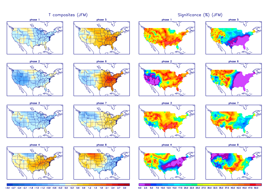
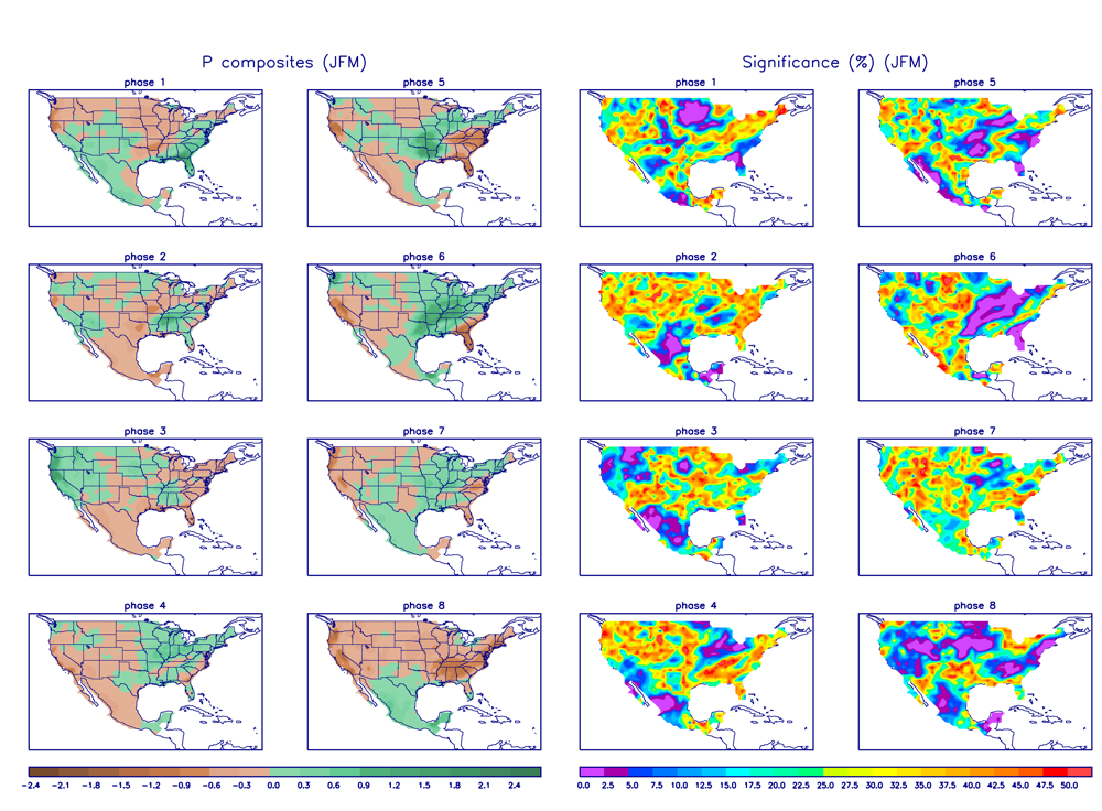
Here are the current composites for California for February. As you can see, the significance is high for precipitation and below normal temps in phases 1 and 2 of the MJO phase space.
Temperature Composits and Significance for Feb:
Precipitation Composites and Significance for February:
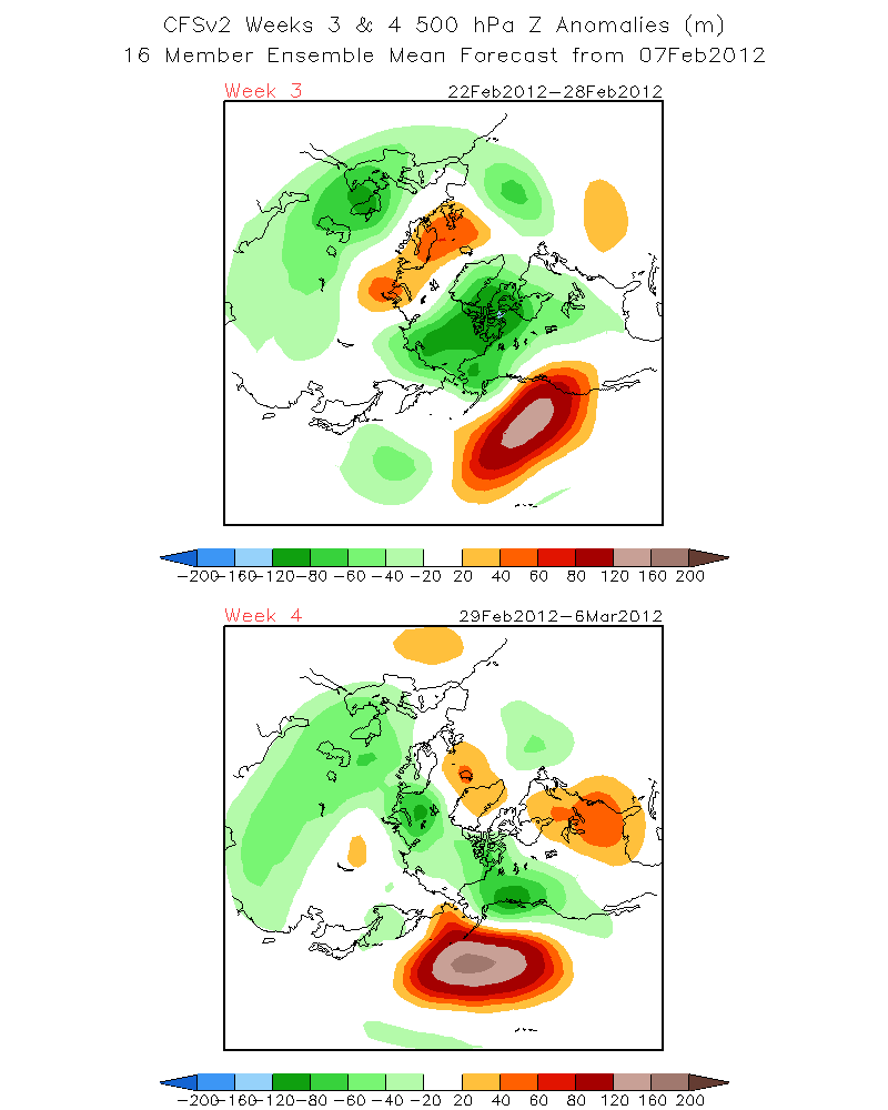
Another supporting model is the “CFSv2 Forecast”
http://www.cpc.ncep.noaa.gov/products/people/sweaver/cfs_fcst/images1/wk3.wk4_20120207.z500.gif
Week 4 (Feb 29th through the 6th of March) Clearly showing the HT 500 height anomaly retrograded west to northwest of Hawaii with below normal 500 heights over the West Coast. This is a flip of the current PNA index.
Dr Howard and the Dweebs…………………………….:-)
————————————————-
Reference Glossary of Weather Terms
Disclaimer: I have been a hobbyist meteorologist for over 30 years here in the Mammoth area and I do this for my personal enjoyment. The National Weather Service saves lives every day . . . I do not. When making important planning decisions please use information provided by the National Weather Service as they are the most knowledgeable and accurate information source available today.


