Brought to you by Howard Sheckter
Last days of Summer to End Friday…..Equinox Saturday Am 7:49 Local Time…..First days of Fall to be Cooler then Cool into Following Week….
Tuesday September 18, 2012
Quick Update Thursday AM:
So much meridional flow over the Western Hemi! The Dweebs love it! Last winter there was such an absence of it most of the time. The AO and NAO continued in negative phase! Weather over the far west will be fair through Friday with a chance of showers developing as early as Friday night. Big full latitude upper ridge will be translating east the next 5-7 days….
Have to keep an eye on the weak upper low off the Northern Ca Coast for its track. If this low decides to track south more west over the Sierra, the chance of TSRWs would increase from its current 20% POPs weekend.
The players over the next 3 days are the upper low, the full Latitude ridge shifting east and, the subtropical ridge that is slowly weakening from the summer. MJO will be in a position to spawn more hurricanes over the Tropical Eastern Pacific late in the month. The WX over the Southern Half of Ca may be influenced by these systems or the debris from these systems as the moisture may travel along the ever changing reconfiguring subtropical ridge line/position over the far West/SW. The current outlook for planning is that any moisture from these systems will be shunted well south of us…..but that can change.
WX over the weekend still looks cooler with a slight chance of showers beginning as early as Friday night then into Sunday night. Temps cooling to the low 60s for highs by Sunday. The Dweebs will keep an eye out for any change in the track of the upper low over the next few days………………………………….:-)
____________________________________________________________________________________________________________________________________________________
The western hemispheric pattern remains very amplified and very mid fall like, unlike the last few days of Summer. Sensibly, if it were not for the fact that the mean ridge position was over the eastern pacific to the west of us, it would be noticeable cooler. The upper pattern is associated with the negative phase of the Arctic oscillation (-AO) where pressures are higher over the Arctic forcing more meridional flow (north-south) over the western hemisphere.
Change in temperatures coming:
While Eastern California will be enjoying the last of the warm summer days, a change in the pattern to progressive will shift the upper ridge axis inland next week. Through the process, a weak upper low off the Northern Ca coast will come inland this weekend…heralding the change. Although it is a small feature, it will bring cooling, clouds and even the slight chance of showers and thunder, beginning Saturday afternoon and into Sunday night. Sensibly, the cooling trend will begin Saturday and continue into early next week whereby Monday/Tuesday, highs temps over Mammoth will struggle to get into the low 60 degrees. (So about 15 to 17 degrees of cooling) Night time lows will dip into the low to mid 30s by Sunday AM. Yes……Fall is arriving both astronomically and meteorologically this weekend!
Outlook:
It appears that it will continue dry next week with normal to a bit below normal temps. The normal highs in Mammoth next week are in the upper 60s. The Dweebs use the algorithm for South Shore Tahoe for the aprox temperature, “This time of the year”. The hpa 500 pattern appears to becoming less amplified toward the end of the month. This will ensure more seasonal temps. So far…..It looks dry in the outlook next week and into the following week. Next long range oppertunity for precipitation, about the end of the month. That may bring us a dusting over the upper elevations.
Further Outlook: (Aways subject to change)
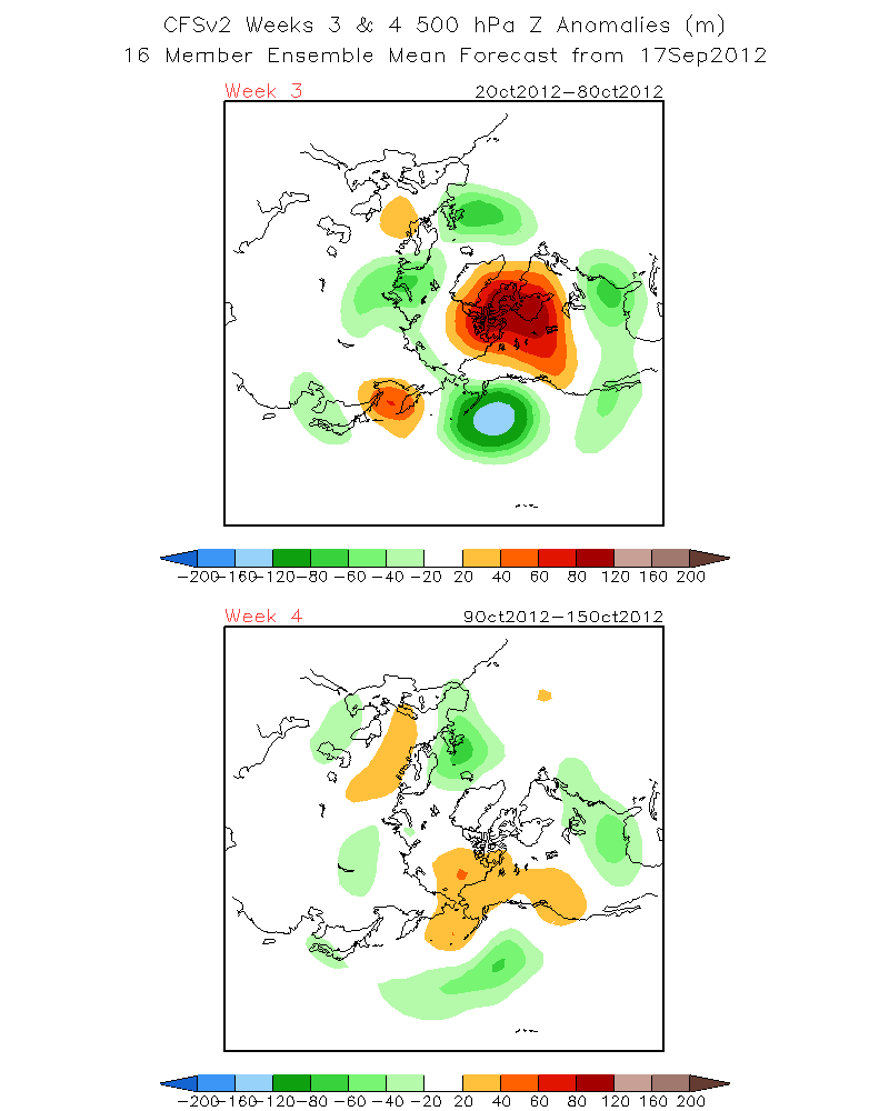
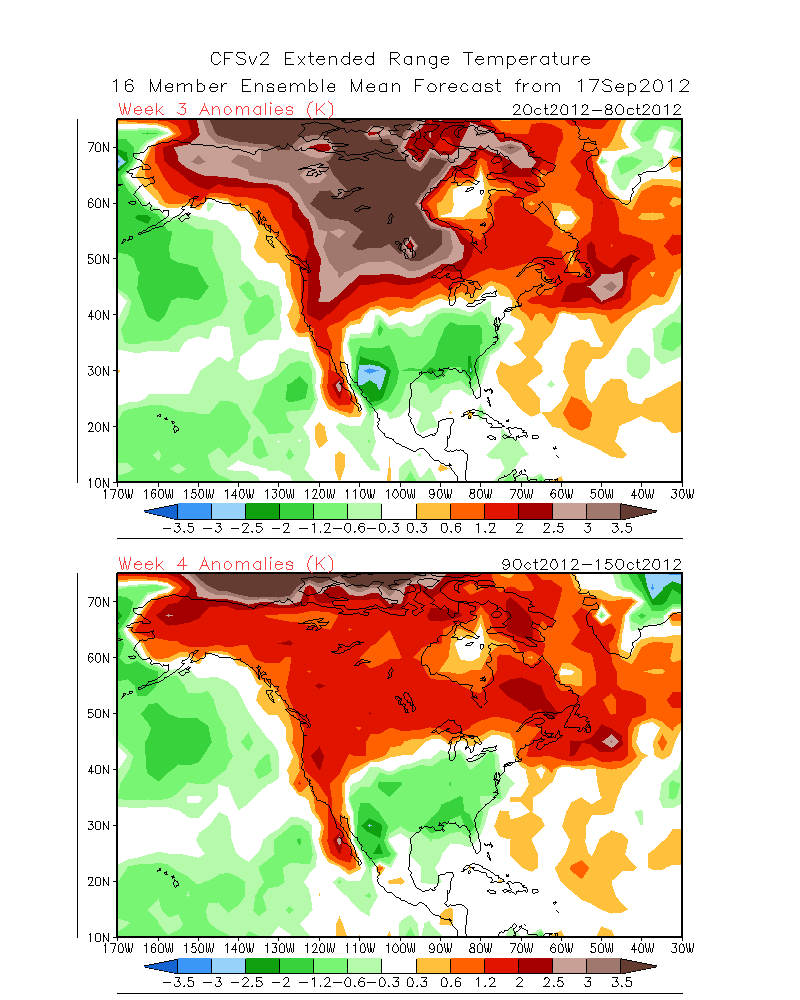
1. This mornings view of the weeks 3 and 4 hPaZ 500mb height anomaly from the CFSv2 model –http://www.cpc.ncep.noaa.gov/products/people/sweaver/cfs_fcst/images1/wk3.wk4_20120917.z500.gif
showed the negative upper height anomaly between Hawaii and the Eastern Aleutians at about 155W and the positive upper height anomaly stretched positive tilt between the Eastern Hudson Bay to the Pacific Northwest. The Positive upper height anomaly weakens and retrogrades somewhat week 4 (second week of Oct.) This pattern should ensure the continuation of beautiful fall weather here in the Eastern Sierra with above normal temps. http://www.cpc.ncep.noaa.gov/products/people/sweaver/cfs_fcst/images1/wk3.wk4_20120917.NAsfcT.gif
Dr Howard and the Dweebs……………………………:-)
————————————————-
Reference Glossary of Weather Terms
Disclaimer: I have been a hobbyist meteorologist for over 30 years here in the Mammoth area and I do this for my personal enjoyment. The National Weather Service saves lives every day . . . I do not. When making important planning decisions please use information provided by the National Weather Service as they are the most knowledgeable and accurate information source available today.


