Brought to you by Howard Sheckter
Cold weather to continue for the far west with next spliting system bringing light amounts of up to 6 to 12 inches over the higher elevations Sunday/Night..Weather to turn even colder by Mid Month….
Friday January 4, 2013
12:00pm Saturday Update:
New 12z ECMWF is in and looking at 240 hours out, dumps all the cold air into the great basin like last nights GFS.
Now take a look at the 6 to 10 day outlook for the Great Basin…..Burr!!!
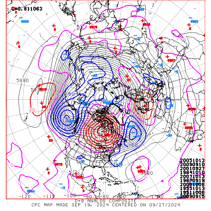
As well as the analogs: http://www.cpc.ncep.noaa.gov/products/predictions/610day/610analog.off.gif
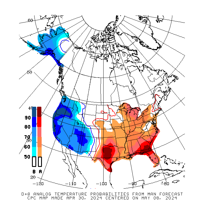
Analog Temps probabilities… http://www.cpc.ncep.noaa.gov/products/predictions/610day/610analog.temp.gif
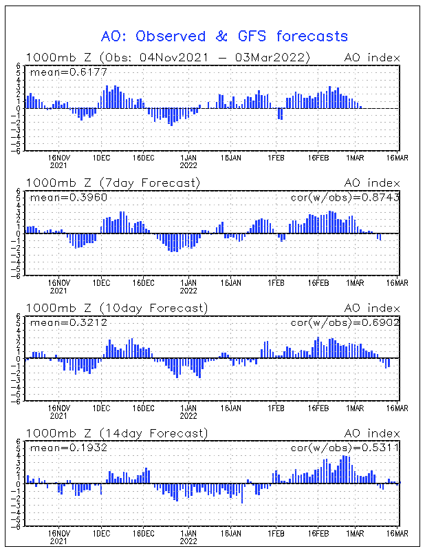
Also the GFS AO forecasts suggest that the AO will tank to standard deviations of normal, > -5 by Mid Month.
See http://www.cpc.ncep.noaa.gov/products/precip/CWlink/daily_ao_index/ao.mrf.gif
If you remember the 27th of December 1990, it was cold!
As a comment,
The up shot to all this is light to moderate snow within the next week…..then cold and a lot more cold the end of next week.
We have a couple of snow producing storms headed our way. One Sunday and Sunday night that will dump about a foot on the hill. 6 to 8 inches at the village for a Sunday night plow.
Additionally, A better snow producer with more wind is expected Thursday which will be the first of several more but drier storms that will deliver Arctic air into the great basin, later the 2nd half of next next week.
Dr Howard and the Dweebs………………………….:-)
Saturday AM Update:
I keep seeing the same trend in the longer range this morning….Burrrrrrr!!!!!
RECAP:
1. It all began with the west warmer then normal in the Fall….then much wetter then normal in the late Fall. Anomalous cold developed in December. All this while the QBO was in its easterly phase with the 30 mb zonal wind index showing -20s in September and -20s in October then -18s in November and rapidly rising to -10 in December. The Quasi Biannual oscillation is represented by an index that shows both the strength of the winds at 30MB, (Stratosphere) from either east to west or west to east. It has been in its easterly phase now for well over a year and is expected to flip soon from from east to west to west to east. From what I have read, the most dramatic effect upon the weather often time occurs during the time around the flip in direction. This is often associated with strong blocking over Greenland, IE a strong -NAO (a strong high pressure block over Greenland) and a deep Hudson Bay Low. The combination of the timing of the flip which is beginning to occur now and will likely continue into February, and what the CPC is touting is leading me to believe that some serious Arctic air is going become entrenched over the CONUS later this month. It will mainly be from the Mid west then shift to the east!..For the folks that are missing the cold over the east, it appears that you are going to get yours big time, the second half of January. This Arctic Air may go deep into the south….. and the AGW crowd will be touting otherwise again!!
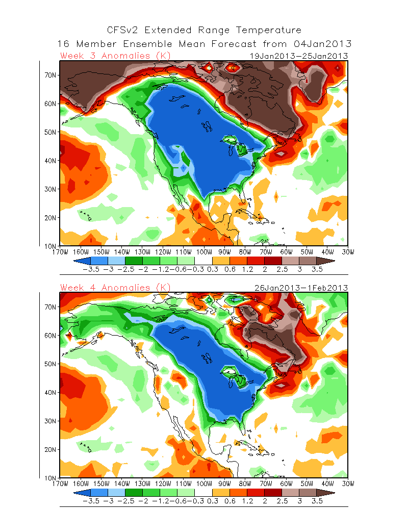
See: http://www.cpc.ncep.noaa.gov/products/people/sweaver/cfs_fcst/images1/wk3.wk4_20130104.NAsfcT.gif
Back out west……there is still the possibility that the first initial salvos of Arctic will begin in the far west with some of the thick soup breaking west of the Divide about mid month. The Cold will then shift east with time. If we do get a good shot of it and ridge over; as mentioned in a previous discussion, Bridgeport may go -25 to -30F.
Take a look at the following link. It is the latest forecast from the CPC for temps across the US. The deviation from the standard is grossly off the chart!
____________________________________________________________________________________________________________________________________________________________________
I took a trip to the Carson Valley, Nv via Bridgeport today. At 1:45pm it was 14 degrees downtown. That was probably about the high for the day after an early morning low of -18. A few days of that are tolerable I guess, but a week or more and I’d be ready for the head bangers ball! Lee Vining next to Mono Lake still socked in with ice fog at about 1:15pm today. I hope you folks get some relief this weekend as a splitting system tries to mix things up a bit. Some snow is expected for the High Country. However, mainly the Crest and south through the Southern Sierra. I would not be surprised if bishop picks up an inch or two of snow Sunday/ngt. Mammoth Mtn is expecting about 4 to 8 inches by Sunday night. Could be 3 to 6 inches in town.
What I have been seeing on and off for mid month January in the longer range concerns me. Especially since it has been so cold for so long in many areas. Not every model is showing this on a regular bases but the new 00z Saturday GFS has the eastern pacific ridge building north at about 145W to the north pole and tapping pure arctic and pulling it South over the far west and especially Great Basin. Temps over Montana at 18,000ft (500mb) go south of -40C. This is just about our coldest weather type should it occur…..Especially in mid January. With so much snow cover over the interior far west and great basin, there will not likely be very much if any modification. Stay tuned…..as the mid month Yellow Knife clipper could be a real pipe buster! If that occurs and we ridge up over the top of that air mass…Bridgeport could go -30f below.
Note this is not a forecast yet. However the trend is heading toward an Arctic Outbreak over the west by mid month or a little sooner. How far west the molasses gets is uncertain at this time.
PS> The QBO is getting ready to flip from east to west to west to east. Looks like Next month will be the timing……
The Dweeber………………………:-)


