Brought to you by Howard Sheckter
Archive for July, 2013
Thunderstorm Chances on the Increase Again the Next Few Days as Mid Level Cap Weakens….Southerly flow to Add Moisture and Dynamics through Friday Evening….Dry weather with Zephyr winds to return next week….
Thursday July 25, 2013
Friday AM 8:14 AM Thunderstorm Threat (High)……Outlook favorable for thunderstorms through Saturday then more isolated Sunday. Dry Monday through Thursday. 8000 ft Daytime highs mid 70s, lows upper 40 and low 50s
Update on the Aspen Fire WSW of Mammoth:
4500 Acres:
The Aspen Fire was discovered on Tuesday, July 23 burning on the Sierra National Forest- High Sierra Ranger District. The fire is burning below Stump Springs Road north of Aspen Springs. Additional resources will continue to arrive assisting in fire suppression. Sierra National Forest initial suppression efforts, crews were able to keep the fire from burning into the Kaiser Wilderness. Firefighter and public safety remains the highest priority.
The South Central Sierra Interagency Incident Management Team assumed command of the Aspen Fire at 6:00 P.M. July 24, 2013. The team is working with the Sierra National Forest to manage suppression efforts.
Smoke from the Aspen Fire is impacting air quality in local communities. Individuals sensitive to smoke are suggested to remain indoors and keep windows closed, to minimize exposure to smoke.
The fire is in steep, rugged, inaccessible terrain. There is no imminent threat to the communities of Big Creek or Huntington Lake at this time.
The Sierra National Forest is suppressing 15 additional fires and all are less than ¼ acre in size; all of these fires were started by lightning.
Basic Information
| Incident Type | Wildfire |
|---|---|
| Cause | Lightning |
| Date of Origin | Tuesday July 23rd, 2013 approx. 12:00 AM |
| Location | Seven miles north of Big Creek; Near Mammoth Pool Lake; 45 Miles WSW of Mammoth Lakes |
| Incident Commander | David Cooper |
Current Situation
| Total Personnel | 858 |
|---|---|
| Size | 4,500 acres |
| Fuels Involved | Timber with mixed chaparral |
| Fire Behavior | Fire continues to burn actively |
| Significant Events | The Closure of Stump Springs road remains in effect. West Kaiser and Sample Meadow Campgrounds are closed. Precautionary evacuation of campgrounds occurred yesterday west of the San Joaquin River on Forest Road 4S81. |
Outlook
| Planned Actions | Utilize air resources continued direct attack when possible. Continue to build handlines. |
|---|---|
| Growth Potential | High |
| Terrain Difficulty | Extreme |
| Remarks | Access to the lower portions of the fire along the San Joaquin River’s edge is an obstacle. Smoke from the fire continues to impact the San Joaquin Valley as well as Mammoth Lakes during the afternoon and early evening hours. |
Thursday AM:
Day before yesterday we were over developed with cloudiness and thus rains did not materialize because of the lack of sunshine and heating. Yesterday….the upper high set up over the top of us and we were capped. Today’s forecast models shift the upper high over NW Nevada which creates a weaker cap….Then tomorrow a weaker cap yet with an increase of moisture and southerly flow in the mid levels.
Upshot is for an increase of daytime convection and the chance of thunderstorms through Friday…..It is possible that some areas of Eastern CA could get in excess of an inch of rain by Friday evening. Hope that’s good news for the fire fighters on the Aspen Fire. However, there will be an increase of lightning as well.
The bad news is that by this Sunday, a Trof of low pressure will be approaching California and deepen next week. This will increase west winds during the afternoon and evening hours and bring much drier air into the region……
Longer Range:
Just like the middle of July, the extended outlook for temperatures will be effected by relatively weak Trofing along the west coast beginning this Sunday, then deepening a bit into mid week. This herald’s the end of the influx of subtropical moisture and a much more stable atmosphere for the high country next week. High temperatures will trend down toward the mid 70s by mid week, possibly cooler. Those pesky west winds (Mono Zephyr), along with drier air will allow for much cooler nights with strong radiational cooling.
This trend/pattern looks likely to continue through the first week of August which will again, lend itself to some what lower chances then normal for rainfall and thunderstorms.
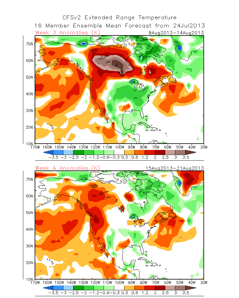
Interseasonally, the longest range charts show height rises for the west coast along with the continental upper high pushing west again beginning the 2nd week of August for Heatwave Pt III and Monsoon Part II for the high country…..About the 8th of August through the 21st.
If your coming up for the Bluesza, bring something warm to ware for the evening…..
See: http://www.cpc.ncep.noaa.gov/products/people/sweaver/cfs_fcst/images1/wk3.wk4_20130724.NAsfcT.gif
Dr Howard and the Dweebs………………………………:-)


