Brought to you by Howard Sheckter
Milder temps on the way today and Wednesday then gusty winds Thursday for the opener followed by a Fair Weekend with Seasonal Temperatures……Next Week we will get snow…Maybe……Timing possibly Mid-Week……
Tuesday November 5, 2013
Wednesday 5:30PM
Here lies the problem..
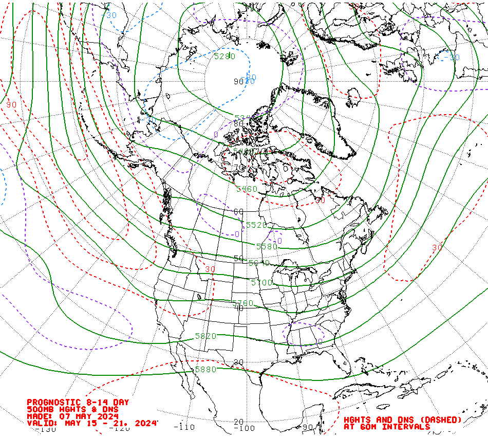
See the Mean Height Anomaly at 175W: http://www.cpc.ncep.noaa.gov/products/predictions/610day/500mb.php
420DM at 52N-175W
Here it is again in the 8 to 14 day outlook:
About 390DM at 50N 180W
It’s moving in the wrong direction as the wavelength if correct will force ridging to develop near the west coast and most of the moisture stays off shore and moves north…..
http://www.cpc.ncep.noaa.gov/products/predictions/814day/814day.03.gif
The Dweebs sincerely hope that this is not what the future holds for us next week. We can still get some light precip but not much if this Multiple Model ensemble mean is correct……The weighting according to the CPC is this….
10 PERCENT OF TODAY’S OPERATIONAL 6Z GFS CENTERED ON DAY 11…30 PERCENT OF TODAY’S GFS SUPERENSEMBLE
MEAN CENTERED ON DAY 11…40 PERCENT OF TODAY’S 0Z EUROPEAN ENSEMBLE MEAN CENTERED ON DAY 11…AND 20 PERCENT OF TODAY’S 0Z CANADIAN ENSEMBLE MEAN CENTERED ON DAY 11. (What a Mess)
Wednesday AM:
Note: Latest 12Z GFS is pure Junk this AM……
New Deterministic ECMWF retrogrades the Key height Anomaly west of the dateline by a week from this Thursday. This is not good for any kind of precipitation for Central Ca. This mornings 12z GFS was probably signaling a change as well. Again both of these are the deterministic runs. We need more time, more runs…into the weekend for a better analysis…..
____________________________________________________________________________________________________________________________
Quick update this morning based upon the ECMWF ensembles show a mostly dry period until about the middle of next week when Central California becomes under the influence of the Subtropical jet. As mentioned before, the pattern change seems to be highlighted by the subtropical jet where even at times there is a coupling of the polar jet to our north. So the cold air for lower snow levels remains mostly to our north. Snow levels will be high with this event later next week and the Dweebs are doubtful at this time that the snow pushers will have much to do during the meat of the storm if the air mass over Mammoth becomes saturated. If you Dweebs have access to the ECMWF Ensembles….look at the 5-9 and 6 to 10 day means. With the closed upper high at 175W and a positive tilt long fetch from near Hawaii, this has the potential to be a very wet period with the polar jet over well over northern California and the Subtropical jet over South Central Ca. There is even the “potential” for an Atmospheric River set up later in the 6 to 10 day period. This is pretty unusual for Central Ca in Mid November……however, so is the Upper Height Anomaly at 175West that will develop in excess of +400DM, while at the same time the subtropical high is pinned over south-central Baja. CPC is favoring the EC Ensembles putting the greatest weight on its members at this time. The long fetch, “should it develop” from near Hawaii with a strong subtropical jet will make for a lot of Rain and snow over the highest elevations later next week. Remember, we still have significant differences in the GFS and EC. I expect them to come together on a solution over this weekend.
Comment: In a discussion from Hanford, mid shift, one Met commented about the positive AO being responsible in part for the pattern. The Dweebs have also read publications about the Non Linear relationship of the AO to California WX. Looks like more research is needed…..
2:15PM Tuesday
Looked at the 6 to 10 day and 8 to 14 day outlooks.
CPC puts the upstream height anomaly of +300 DM in the 8 to 14 day period and +420DM for the 6 to 10 day period in the same place. Both centered between 170W and the dateline. That is quite a ridge out there. Too Bad it is anchored between 170W and the Dateline. This definitely put the Bull’s-eye up along the CA/OR or even further north for the next too weeks. Although above normal precipitation is expected for the Central Sierra, the 564 Mean iso height contour is over South Shore Tahoe. This means that the polar Jet will remain mostly north of Mammoth with just occasional deviations to the south. Orographic’s will play an important roll.
For the most part, it will be the subtropical jet that brings us precipitation and so expect high snow levels much of the time. Of course Sierra Cement is exactly what we need early in the season…….
The Dweeber……………………:-)
More later…………………….
Tuesday Am Update:
The Dweebs are beginning to see and understand the differences between the EC and the GFS now as the new 12z GFS run arrives today. The main differences “has been”:
1. The GFS’s earlier timing of precipitation due to the emphasis upon the lead short wave for Next Monday into California.
2. Whether or not the emphasis by the EC on a significant Subtropical Connection is warranted.
This morning’s 12Z GFS run is beginning to “dampen out” the lead short wave into California which weakens at best that short wave.
Additional energy develops a deep positive tilt upper trof with quite the subtropical fetch like the ECMWF. As is the case this time like many times……The ECMWF seems to have a better handle on eastern pacific energy in my estimation 10 days out then the GFS. So if you only look to the GFS, your missing at least half the story, 6 to 10 days out.
One thing is certain, there are no guarantees at this time of how much precip we will get or when it will begin. However, it looks more likely later than earlier like the ECMWF. Northern California still looks favored over Central CA and Southern California does not get much at all at this time. Another concern is where the up stream ridge is developing……about 170W. That allows for the downstream subtropical ridge off the west coast to be a hinder on the digging trof. Would like to see the upstream ridge progress to 160West which would be better….
More later today or tomorrow AM
Dr Howard and the Dweebs………………………………….:-)
———————————————————————————————————————————-


