Brought to you by Howard Sheckter
One More Quiet Day Today then Cold Slider Pattern to Develop Thursday Night with one-two punch…..Coldest slider to flush through Saturday Night…….Outlook still dry with milder temps returning later next week….
Wednesday November 13, 2013
Thursday AM Update:
No sensible changes in the short term forecast, just cold on the way. Little change in the medium and long-range charts.
Odds are strongly against any meaningful precipitation before Thanksgiving.
Short term is most positive for snow making as a couple of dry cold fronts sweep through our area this weekend.
Oddly enough the first has the coldest air with it as the second is now taking a further eastward track.
There will be wind, cooling and a few snow showers Saturday. 700MB temps to drop to -5C by Friday morning but not as cold
Saturday AM.
There is some indication according to the CPC that the MJO may affect the weather over the CONUS week two. Not sure what that will mean for us.
One thing is for sure…..the Long Range maps are pretty ugly!
Stay Tuned…………………….
Dr Howard and the Dweebs……………………………:=-)
12:00 PM UPDATE
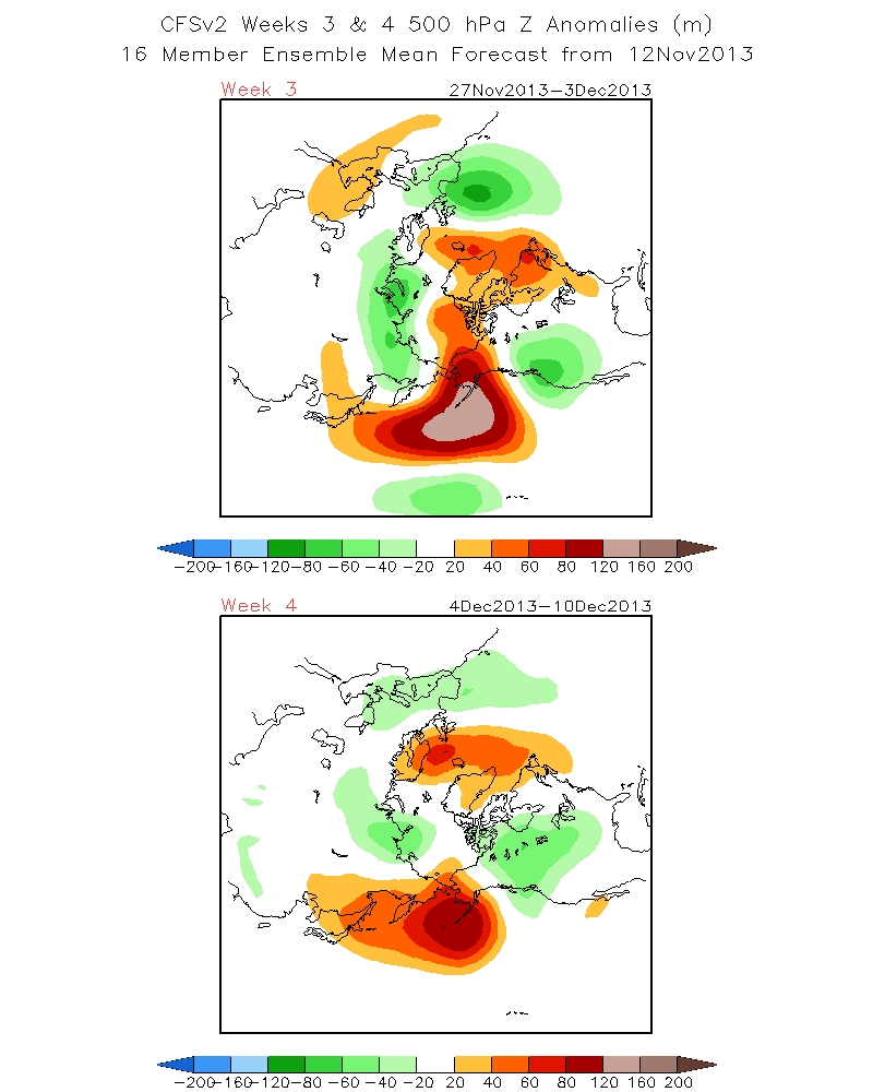
New CFS has weeks 3 and 4 wet….. Especially Week 3 which includes Thanksgiving Day through the 3rd of Dec.
SEE 500Hpa 7 day means show blocking in the Red and Below normal heights in Green.
http://www.cpc.ncep.noaa.gov/products/people/sweaver/cfs_fcst/images1/wk3.wk4_20131112.z500.gif
It appears that one more nice day today will be followed by a couple of inside sliders. The First flushes through early Friday morning. This one is not a true slider as the subtropical jet plays more a role on the pattern with cloudiness and cooling. It is interesting to note that both small, weak Jet-lets of both subtropical jet and polar jet become coupled over Central CA Thursday evening. Although there is limited moisture, there is an approaching VT Max on this mornings 12z NAM worth watching. IE. We may have a snow shower Thursday night….
It will be growing colder through the weekend as the next….. and may I add more robust short wave within the polar jet approaches. Again there is limited moisture showing up with this system, however the upper jet suggests that it may get pretty windy in the deserts and mountains as well. A westward Jog of a hundred miles or so would make quite the difference on precip too. However…the new 12Z GFS is not buying into that as it is keeping the upper jet well inland over the Nevada/CA border. So the period to watch for the most dynamic portion of the pattern will be Saturday afternoon through Sunday AM. The Dweebs are not expecting more than a few snow showers at this time, in that the new 12Z guidance is slightly east of last nights run….I have little hope that anything meaningful will fall in the high country. So…..Cold it will be with highs over the weekend in upper 30/40s by Sunday.
OUTLOOK:
The latest 12z GFS run shows the upper jet translating east quickly. So upper ridging will take over CA Monday with temp inversions setting up. Looking at the longer term….a long wave trof deepens west of the Hawaiian islands…..that pumps a ridge up just off the west coast in the longer range. We just can not get a break!!
In the meantime, snow making conditions are going to be very good on Mammoth Mountain this weekend and I am sure that the snow guns will be going both day and night Saturday and Sunday….So more runs will open for the following week……
Think Snow and remember…….According to Dan McConnell, “When you do your snow dance, do it from right to left otherwise it will not work”…..;-)
Toms Corner….for our esoteric readers….
Update: latest 12z GFS runs including ensembles trending toward ECMWF solution keeping jet and cold air further east over Great Basin this weekend. Wave off Japan was not as deep as forecast and was not deepening or bombing out so amplification was weaker (although Hovmoller timing was the same).Series of weaker sfc lows or wave coming off Asia are keeping pattern progressive and flat 5 wave or greater wave number.. Still uncertainty next week with troughing or undercutting off Pac NW coast could led to moist wly flow into Nrn California by mid week (See Canadian model and some GFS ensembles.) Moist confluent jets forecast to develop by next Tuesday between developing Gulf of Alaska trough and Quasi stationary upper low north of Hawaii setting up good warm advection overrunning pattern with good upper level difluence. Stay tuned for further updates and remember October/November are worst months for model verification as continents are cooling and becoming snow covered (diabatic affects) while tropical convection and typhoons injecting lots of unaccountable energy (latent heat) into global circulation pattern.
The Dweeber……………………………:-)


