Brought to you by Howard Sheckter
Another dry week ahead is expected for California while week two models still beat with the promise of some snowfall during the 1st week of February…..
Thursday January 23, 2014
Sunday AM:
Storm for later next week still looks good….a foot plus up on the hill…..GFS has it starting earlier like Thursday….ECMWF is wetter with about 1.5 inches of water EQ.
Stay tuned…will update daily…………..
The Dweeber…………………….:-)
Saturday PM
That’s it! I have heard this silver bullet story again today….The media is quoting some climatologist saying that the warm water pool in the Gulf of AK is causing the drought. If I hear this one more time I am going to be ill!
I do not believe in the -PDO and Warm water pool Gulf of AK drought connection and neither should you! It is another knee jerk, silver bullet answer for a system or structure that is wagging the dog from much further away then a few thousand miles.
If Air Sea coupling was really working in the Eastern Pacific, we would not continue to have the kind of weather that we have In January. It would Cold and drier than normal not warm and drier than normal.
1. Warm Water SEE: http://weather.unisys.com/surface/sst_anom.gif
This warm water pool near 150W and 42 north is usually there! It is usually found between 160W and 150W. If it was really coupling, the upper high would be just to the east of it and a long wave trof would be over the far west. IE (30 degrees east of the anomaly) The -PDO which in this neck of the woods equates to a colder N/S west coast current, has weakened recently. Colder SSTA supports trofing not ridging aloft. So in effect, if that was driving the pattern, it would be cold over the far west and showery! Is it cold and showery? California has been setting high temperature records for the past two weeks!
Air sea coupling is important, However,
1. Did this guy realize that the MJO in phase 6 often teleconnects to ridging in the NE pacific? How about the fact that this is a La Nada year with little if any support to southern stream enhancement! That the QBO in its positive phase is much more convincing for west coast dryness in La Nada years then the -PDO/Warm Gulf of AK connection.
Take a deep breath!!!!!!!
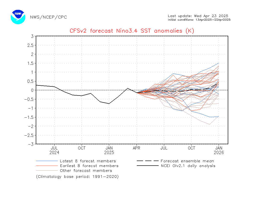
The most exciting news out there is that significant Kelvin Wave action is taking place that may have greater benefits toward the development of a significant El Nino for Next Fall/Winter……
Check this out and then check you pulse!
Now that’s what I’m talking about!
http://origin.cpc.ncep.noaa.gov/products/people/wwang/cfsv2fcst/imagesInd3/nino34Mon.gif
Saturday AM
A storm is still on track beginning early Friday AM next week. This looks like the potential to be a moderate precip producer. This means that it could dump a foot between Friday Am and Saturday AM on Mammoth Mtn Although this is a wag at this time….. I will update; weighing in each day now on the progress of the pattern change into next week. As far as the pattern goes, it will be in transition (retrogression day+8 thru day+11) …….eventually turning much colder week 2. (Post super bowel)
Forecast:
Fair and dry with high cloudiness on and off the next few days…. Highs in the 40s today then 50s next week up until Wednesday. Winds will increase Thursday and Thursday night with a Chance of snow developing by Friday. This will be a cold storm, so expect snow and not rain.
At this time I do not see a major change to a wet pattern for California.
Dr Howard and the Dweebs………………..:-)
Friday PM: 5:45PM
The pattern changes are beginning to get into the later part of the week one period and it still appears that we’ll get some light snowfall next weekend. Like between the 31st and the 3rd. Is this finally the end of the drought pattern? I say no…..Just a break for the time being… However, this break may allow some important snow to fall later next week.
Looking at the MJO it is strongly in phase 6 with no sign of moving. To me that locks in the north East Pacific Ridge with down stream effects of more arctic shots…however, as time goes on these shots will drop into the US further and further west as retrogression of the eastern pacific ridge takes place. I am not sure how far west the ridge retrogrades but it may get west enough for some pretty cold weather out west later week two.
From the CPC::
Persistent convection near the Eastern Maritime Continent and parts of the West Pacific could have important impacts on the extratropics from the North Pacific downstream into North America. In recent observations, an extension of the East Asian jet stream has been observed, consistent with convective forcing from the West Pacific over the past week to ten days. Therefore, the forecast pattern of tropical convection favors continued ridging in the Northeast Pacific over the next few weeks.
So far the southern stream is still very weak over the eastern pacific. This is probably due to La Nada. A strong southern stream would break loose the westerlies into CA if we had a moderate El Nino. So this is unlikely to happen.
———————————————————————————————————————————————————
Friday AM Update:
The weak upper low that back doored us yesterday is now off shore and moving north while some high level subtropical moisture was pulled up in its wake. They are just high clouds for the most part and will not produce precipitation. The clouds should thin out during the day as the upper circulation off-shore, pulls north.
Highs today will be in the mid 40s with lows at night in the single digits, teens and twenties depending upon your elevation. The coldest temps will be in the valleys like Bridgeport. Warmer days with clear sky’s will return Saturday and the trend of warming continuing through the middle of next week. Expect daytime highs about 60 by Wednesday and again Thursday.
It is what happens after Thursday, what is on the minds of most, as we finish the end of the month and begin the next. The longer range models are all about building the upper high to some extent NW toward Alaska with both retrogression and a weakening of the heights in the mean along the west coast. This leads to the possibility of a westerly break through of energy for the central west coast between the 31st and the 2nd. ( IE Super Bowl Weekend)
The Dweebs should have a better handle on it by next Tuesday or Wednesday.
Of Note…At this time there is no forecast confidence of how much precipitation we will get at this time…..
Stay Tuned………………………………………….>>>>
The Dweeber……….:-)
While near record high temperatures occurred in the Owens Valley this week and short-term models spend their time determining how much warming or cooling is expected each and every day going forward, a pattern of transition is expected the end of the month into the first week of February. The Dweebs have been reluctant to stick their necks out and say that the change will bring snowfall. However, I think that it is not unreasonable to believe that before the end of that 1st week of February, that at least some snowfall will bless our area with light to possibly moderate amounts.
Forecast:
Expect high cloudiness today due to a small weather system back dooring the sierra as it moves east to west off shore. The system will head up the coast toward Canada Friday. Some light snow showers or flurries may occur tonight. It will be about 10 degrees cooler today and slightly warmer tomorrow. Expect strong inversions to return by the end of the weekend. Some gusty winds will likely continue over the upper elevations the next few days.
In case you have not noticed…the days are getting longer and the sun is in return to equinox. For this winter, this is not a bad thought as I have hopes that the current pattern that is entrenched, will get broken up by an increasing amount of differential heating as the North American continent slowly begins to warm in February. Breaking the legs of drought structure is a concept that is simple in thought. However, every month has its own climatology and is effected differently by the variables of Air/Sea/Solar/tropical convection/snow cover and the upper level wind systems that come together for a single days weather.
Sensible Weather:
The weekend will be a fair one, with highs in the upper 40s for the most part ,then low to mid 50s by mid-week. Nights will be in the upper teens tonight…then moderate back into the 20s this weekend.
By next week toward the Super Bowl weekend we should have much better visibility from a weather perspective on how this new pattern will affect California Weather. Will it dumps for days?….or will we just get wind and light snow……Stay tuned….
Although the next Sunday is Super Sunday…..out in the west The Ground Hog will take center stage…after all, is he not the greatest prognosticator?
Dr Howard and the Dweebs……………………….:-)


