Brought to you by Howard Sheckter
Warming Trend peaked Thursday with little change in Temps expected for the High Country Friday…..Overall the next few weeks will be highlighted by both warming and cooling periods….Although Low temps will return to freezing by mid week….Only snow showers are expected late Monday night and Tuesday…..Another warm-up is expected into that following weekend…..A “New” Kelvin Wave is Moving into the Indian Ocean…..
Friday May 2, 2014
PDATE VIA WEATHER LETTER MONDAY AM
http://data.mammothweather.com/landing/
Monday AM:
Nice break in the weather for the first 2 days of the week. Time to create snow storage for the next storm cycle that will begin this Wednesday. The next series of storms will be much colder and should for the most part be all snow for the Town of Mammoth except for the very beginning Wednesday afternoon.
The freezing level drops quickly late in the day Wednesday. Best estimate for snowfall for the Town of Mammoth will be 3 to 6 inches by Thursday morning; so this will be a smaller system snowfall wise, with up to a foot on Mammoth Mt.
The following storm will be colder and could bring 5 to 10 inches in town by between Friday AM into Saturday AM with up to 18 inches on Mammoth Mt. by Saturday AM. Saturday looks showery in the morning with improving weather in the afternoon into Saturday night.
The last in the series of storms will move in Sunday afternoon. The Sunday thru early Tuesday AM storm is a bigger storm that will be slower in moving. However, its main thrust “might be Southern CA “where some 4 inch amounts of rain may fall in their local foothills. This is expected to be between Sunday PM and Tuesday. For Mammoth, I expect a foot or two in town and possibly as much as 3+ feet on Mammoth Mt. So totals from the next storm cycle looks to be between 3 and 6 feet on Mammoth Mt between this Wednesday and the following Tuesday. Thereafter, I expect a long break….possibly until the next storm cycle begins sometime during the 1st week of February…I will update snowfall amounts (QPF) later this week.
The Dweeber………………………..:-)
Friday Evening:
Forecast on track for another hot dry first half of next week under the influence of strong High Pressure Aloft. …..Please be very careful when camping and with fire….Check with Forest Service in regards to campfires. “Our Forests are Tinder Dry”….
Heat will peak tomorrow Saturday with highs in the mid 80s in Mammoth; then expect about 5 degrees of cooling early next week as the upper high shifts east and the upper flow back to the southwest. That is still a dry pattern. Temperature’s will begin to warm up again next Wednesday into that following weekend with a little different pattern. A strong subtropical continental upper high develops next weekend over the deserts and there is the possibly that the upper flow will become southerly as early Thursday of Friday. The odds then will increase for thunderstorms next weekend. Thunderstorms may begin toward next weekend or over the weekend. It looks like the upper flow becomes channeled out of the SSE as well. According the ECMWF, there is also an easterly wave moving across Northern Mexico Thursday and so that will add to the import of moisture late next week. Will update this coming week as the models will have a better handle on all this by Wednesday.
As per the discussion below, the suppressed state of the MJO is still over the tropical eastern pacific and will shift east and weaken into the Western Caribbean by the end of the month. In its wake the next active convective state of MJO now over the western pacific will shift east into the Eastern Tropical Pacific increasing a large area of divergence about the end of the month. Anything from MCC’s to tropical storms may form; Details forthcoming later next week. As the current upper high settles in over the four corners states, southerly or south easterly flow will develop by the end of next week and into the following week. So an increasing chance of thunderstorms will result into the first week of July as well. Strong tropical eastern pacific upper divergence will add to the potential for rainfall here in the Eastern Sierra the first week of July…..Stay tuned….
ENSO:
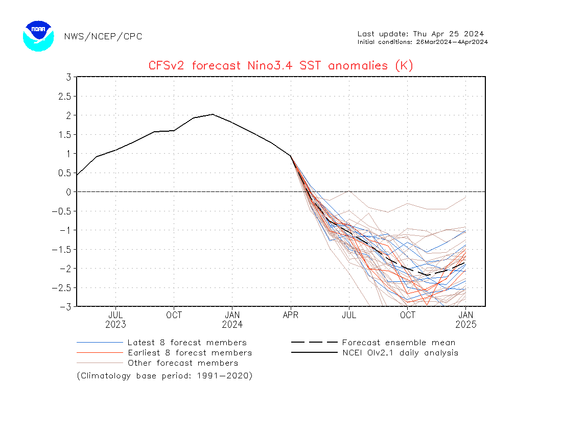
We are now passed the Spring Barrier for predictability for El Nino:
Compare the #1 forecast for the NINO 3.4 region from May, to #2 the latest June forecast. PS, this is not the official forecast but the trend is significant!
Time for Angeleno’s to start building an Ark? This is beginning to look scary…..
1. The Forecast May 20th through the 29th for The Nino 3.4 Region http://origin.cpc.ncep.noaa.gov/products/people/wwang/cfsv2fcst/imagesInd1/nino34Mon.gif
2. The Forecast June 9th through the 18th for the Nino 3.4 Region. http://origin.cpc.ncep.noaa.gov/products/people/wwang/cfsv2fcst/imagesInd3/nino34Mon.gif
————————————————————————————————————————————————————————————————————————————————-
Brief Update:
There appears to be quite the warm spell in our future about mid month. There also appears to be quite the cool spell during the last week of the month. With the cool spell, will there be much snow fall to deal with….Possibly. Remember…the last frost with climo-support is the 21st day of June.
More on that early next week………
The Dweeber………:-)
You can see it in the upper jet when you look at the guidance. The upper jet continues to weaken and the belt of westerly’s are shrinking up. As we get further into the month of May, there is less energy in the westerly’s to push into the west coast. Cut off lows are much more common with the chilly periods, and such periods are shorter in duration. Both ECMWF and the GFS Ensembles show two periods of unsettled weather. Next Tuesday into Wednesday and another about the middle of the month of May.
The current pattern is highlighted by a blocking upper high over Alaska while directly to the south, a chilly upper low of 538DM at 500MB. This low pressure system is suppressed south of the block with its upper jet pushing into the pacific North West Saturday and into Sunday.
Our warm upper ridge breaks down Friday with heights crashing over California Saturday into Sunday. Both Saturday and Sunday look very breezy to windy over the crest as strong zephyr like winds develop Saturday and continue into Sunday. 500-1000mb thickness falls of 250 DM is expected between Friday PM and Tuesday. So about 25 degrees of cooling is expected through that period. It is interesting to note that as the upper trof passes to the south of the Alaskan upper high, the upper flow around the upper high becomes coupled with the trof. The trof then receives a good shot of energy which digs the trof down into California Tuesday. The problem with the scenario is that the main vort center, comes through very early in the morning as well as is being over land. (Dry) The FROPA will be Monday night. The best chance of some showers will be Monday night through Tuesday night. In that the system is moisture starved, CRFC only gives our area a few hundreds. I guess we could get a dusting or ??? Latest QPF shows an increase to .40 over the crest so a few inches is now possible over the upper elevations. The upper trof shifts east Wednesday. Although a warm up develops Thursday into Friday, the latest guidance provides more uncertainty now on the strength of the warm-up as the EC has the upper block retrograding from AK westward and its ridge scenario is certainly weaker as compared to the GFS strong solution.
Of note, the new 12Z Friday GFS actually has what appears to be the 1st eastern pacific tropical storm of the season forming in the newly warmed equatorial waters from the latest Kelvin Wave. If she forms as progged, her name will be “Amanda” and she may affect the Southern tip of Baja or Sea of Cortez about mid month or shortly after…. May 15th is the beginning of the northeastern pacific hurricane season.
Climate:
The Dweebs are excited to note this morning that a new and may I add “Robust” Kelvin Wave has just moved into the Indian Ocean. This is the 2nd Kelvin Wave this year that will be moving east along and North of the Equator toward the western pacific and eventually east to the coasts of South America. It is thought that Kelvin Waves, which is an Air/Sea coupled wave, can jack-start El Nino by the process of upwelling then down welling very warm SSTs from the western pacific to depths approaching 300 meters. The wave travels east, then I believe surfaces toward the eastern pacific. This adds anomalous warmth to the SST’s from the central pacific to the eastern pacific which in turn increases anomalous convection over the Nino Basin. This new Kelvin Wave is number 2 of probably 3 that will further increase SSTA’s throughout the Nino Basin this year.
This is a very significant event!
More later on the progress of this Kelvin Wave this Spring and into the Summer……
This will be my last post until the 12th……..Adios!!!
Dr Howard and the Dweebs…………………….:-)


