Brought to you by Howard Sheckter
Archive for January, 2015
Mostly Cloudy Skies to give way to Sunshine Saturday…..Gusty North to NE winds are expected over the crest with light breezes else ware……Dry weather is expected through Mid Week……A chance of high elevation snow next weekend…..
Friday January 30, 2015
Saturday AM:
Some changes are taking place out of the central pacific that over time may affect Northern CA and the Pacific NW. There is a large cyclonic gyre (Long Wave Trof) that has developed north of Hawaiian Islands that is for the time being a part of the REX block associated with the -WPO. For the time being The system is just a large REX. However, by week 2 the GFS model shows the Arctic opening up with cross polar flow into the Central Pacific. The pattern suggest a major “AR” event for the Pacific Northwest south to Northern CA by Next weekend. If the Baroclinic Zone gets into Central CA, we cold get rain and high elevation snow. The chance of that looks around next Saturday the 7th of February. The west coast ridge is still there…however, the jet energy is so strong, it dampens it pretty good. As a side note, the MJO is in phase 8 which lends interseasonal support to this notion. Just as a side note, a shift of just 100 – 150 miles south would make a huge difference in precip amounts for Central and Northern CA next weekend.
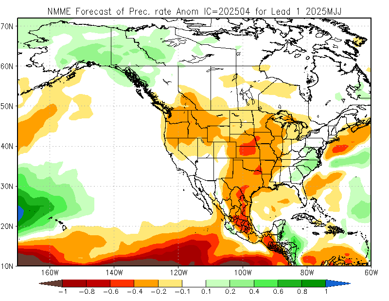
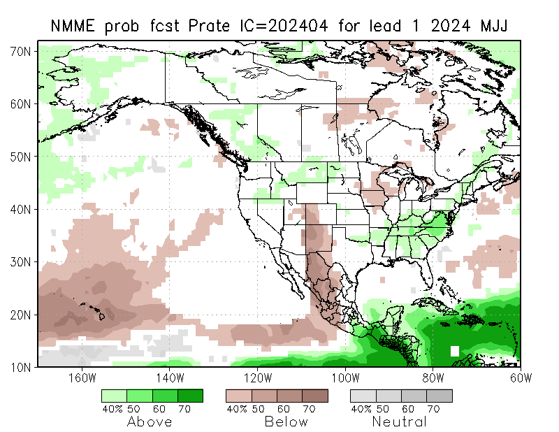
The Dweebs have done a researching this morning looking at several climate models for the next three months. The consensus is that it will be wetter then normal for the period February-March-April. Looking at the Multiple Model Ensemble which combines all the Climate models as an average;
See: http://www.cpc.ncep.noaa.gov/products/NMME/current/images/NMME_ensemble_prate_us_season1.png (For precipitation)
See: http://www.cpc.ncep.noaa.gov/products/NMME/prob/images/prob_ensemble_prate_us_season1.png (For probability)
Additionally, it looks like the PDO will remain in the positive phase for some time now. Which usually coincides with warmer than normal SSTA for the California Coast.
And….according to the last Scripps update early this month, EL Nino conditions may make another run for it again next fall.
…………………………………………………………………………………………………………………………………………………………………….
The Dweebs had a good look at all this mornings guidance and they still are singing the same tune, as the ever resilient ridge keeps its grip upon California. Although there is no formal consensus on, or explanation why the west coast ridge has been so persistent on the time scale as such, our 6 to 10 day outlook continues to show a persistent ridge over the far west.
Water wise, the information from DWP shows that there is “about” the same amount of water in the snow up on Mammoth Pass as there was last year at this time. However, last years data showed that it begin to increase in early February, where our current 6 to 10 day outlook continues to be dry. It should be noted that at this time, the confidence level in yesterdays 6 to 10 outlook was at 80% as compared to the 8 to 14 day outlook the same time which was indicated to be only 40%. This may mean that there is possibly of a transition going to happen around the middle of the month of February which coincidently goes along with the 21 day cycle. So sometime around the 11th or 12th there could be a pattern change. However, remember that we can always go from one dry pattern to the next and that has been happening during that last two transitions. I am referring to the transition of the 1st of January and again about the 21st. The 21 day cycle was brought to my attention by a former Lead forecaster of the NWS over 10 years ago and I think that it may have been related to the Late Meteorologist, Ernest Hovmuller’s time scale work.
Although, the drought producing system continues to be a strong one that has its grip upon CA, I still expect it to break during the 2nd half of February, with a good chance of significant precipitation before month’s end and into March. This is based upon a current consensus among the various climate models.
Dr Howard and the Dweebs………………………..:-)


