Brought to you by Howard Sheckter
Mammoth Mt Reports 10 to 16 inches Storm Total…..Cold California Trof to Begin Moving East Early Tuesday with an Upper Ridge Building in Mid week…..Thereafter…The Weather to remain fair through this Weekend…..
Monday March 2, 2015
Thursday AM
The Global Models are having more difficulty with Pacific Pattern for later next week trying to bring in a decent system. The idea of an “AR” event seems now to be off the table for the time being as models struggle with a pattern shift next week. It does look like we will get some precipitation, however at this time it does not look like a major storm. With that said, that could change. The Dweebs will have better visibility by this Sunday or Monday.
To add to the uncertainty, the MJO is forecasted by the NCEP models and EC to be quite strong in the Phase 7 then weaken into phase 8 region. That is the breeding phases for an “AR” event. So while the global models struggle, there is a bias for the AR because of the Amplitude of the MJO in the right phase spaces. Do not be surprised over the next week to 10 days, that the global models flip back to the AR scenario again. SEE: http://www.cpc.noaa.gov/products/precip/CWlink/MJO/CLIVAR/NCPE_phase_21m_full.gif
The Dweeber……..
Wednesday AM:
This was a Cold Morning in the high country with lows any ware from the low single digits to as cold as -12 at Anchorite, NV near Bodie. A cold dry air mass continues to spill south at 500MB over the Great Basin while the forecast shows upper ridging building in the next few days. This all adds up to a warming trend that will be most sensibly felt Thursday through Sunday. Highs at 8000 ft are expected near 60 for Sunday and Monday next week. Night time lows will still be cold the next few night but not as cold for the upper elevations. By Saturday and Sunday lows will range in the upper 20s to low 30s at 8000 ft. The air mass will become inverted by Saturday near 8000 feet at night, and freezing level will continue to rise this week….
The weather looks fair through Tuesday but expect increasing winds aloft Tuesday leading to the chance of a storm Wednesday or Thursday next week.
The Dweebs are still watching for the possibility of an AR event later next week as the ECMWF control is all over it. The GFS did its dance too last night run, but was not as convincing. Usually, the European is the better model for longer range as a rule…..So the GFS may snap back into agreement. As mentioned the past day or so, the MJO is lending support to an West Coast AR event week two, extending well on shore to the Sierra Crest…. So the Dweebs are watching and eagerly waiting to see what happens as we get closer time wise….toward the 15th of March.
Dr Howard and the Dweebs…………………………………:-)
————————————————————————————————————————————————————–
Tuesday Noon:
Hello Fellow Dweebs…..I do not think I have ever addressed the reader’s as such. However, if you read this blog even weekly, I believe you’re a Dweeb! If you have been reading it for 10 years…..Your in serious trouble! 😉 October this year will be my 35th anniversary of broadcasting weather for the Eastern Sierra, beginning with KMMT and then KIBS which I still to this day broadcast live from my home 5 to 6 days a week. Getting to the point….If some one out there would like to sponsor me to do the weather by-weekly on the Mammoth Cable Channel 12, txt Dan McConnell at 760 937-2043 to chat about it. It would be helpful even through the end of April. Dan says it costs $300.00 a month and includes a video Ad for your business. Txt him if your interested…..I am happy to do it for free…. Please support Dan, who has been an actively video photographing Mammoth and many of its events since 1979…..
Weather Discussion:
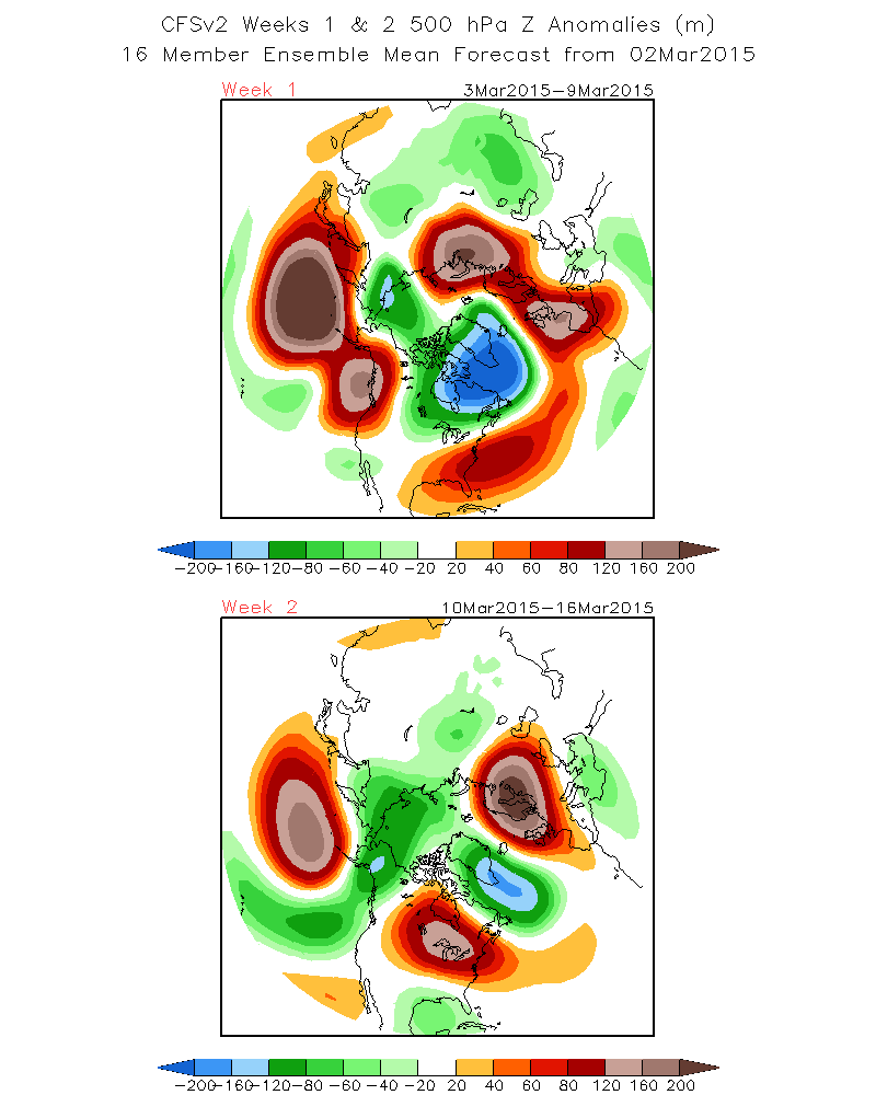
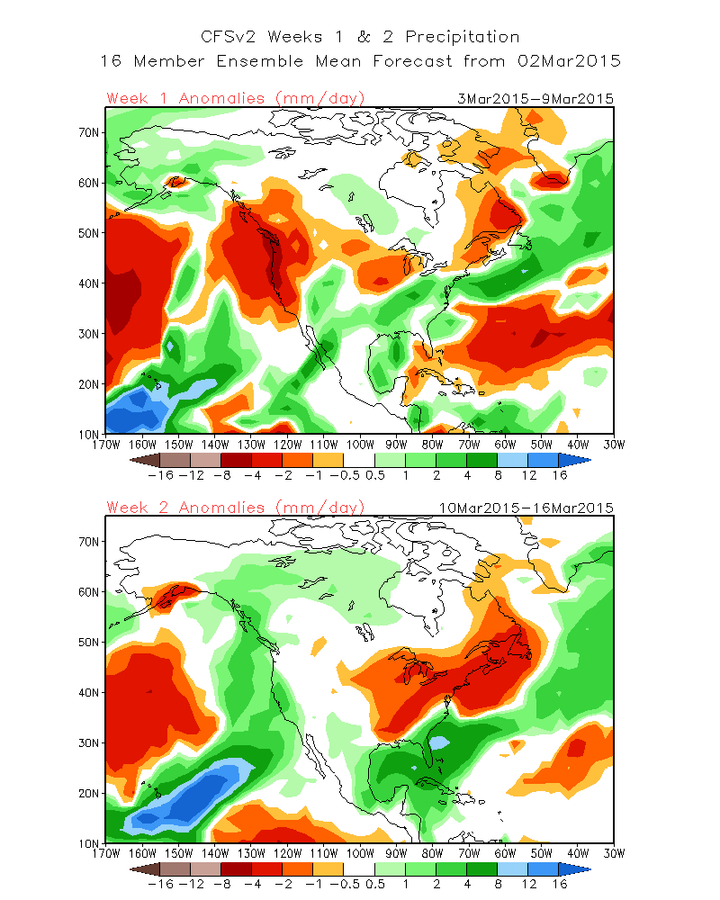
Although it will be warmer through this weeks end, there are several important changes that will take place before the end of March that may bring a lot of moisture to the eastern sierra. The climate weekly models have been touting some kind of a Tropical or AR event for the west coast for a couple of weeks now. It is getting closer in time, and although not an official forecast, I have to say there are some interesting curiosities that are getting closer in time that one has to start taking a bit more seriously. Why? One reason is because not only has the GFS been touting a Possible AR event, but the ECMWF is showing it now as well. Additionally, there is MJO support as well over the next two weeks. If it was not for the MJO support, I would not be all that excited about the future, but its strong and impressive. Here are some Anomalies: The following is the CFS V2, 500 MB heights Anomaly and then Precip for weeks 1 and 2 See the confluence for the negative height anomaly confluent with the ‘AR” That is serious if it occurs. This is for the period March 10 through the 16th .
See: 1. http://www.cpc.ncep.noaa.gov/products/people/sweaver/cfs_fcst/images1/wk1.wk2_20150302.z500.gif
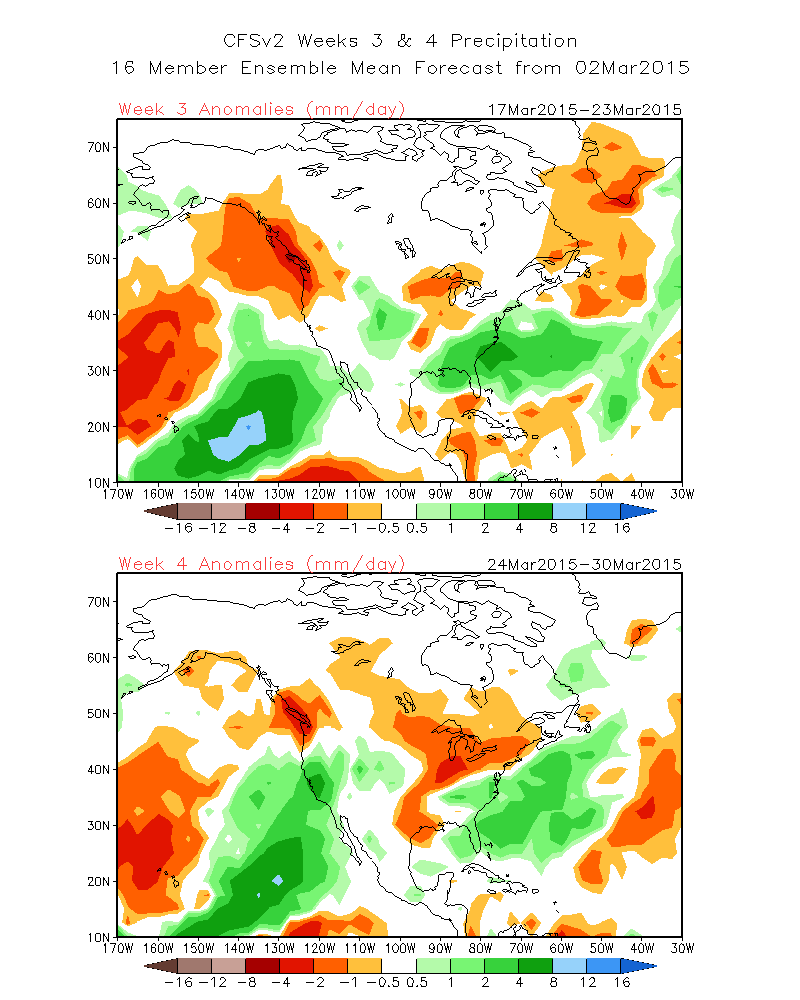
2. http://www.cpc.ncep.noaa.gov/products/people/sweaver/cfs_fcst/images1/wk1.wk2_20150302.NA.gif Here is the progression for Weeks 3 and 4.
3. http://www.cpc.ncep.noaa.gov/products/people/sweaver/cfs_fcst/images1/wk3.wk4_20150302.NA.gif
At the moment we’ll just have to wait and see how everything comes together…….No Forecast, Just looking outward….
The Dweeber………………………………:-) ————————————————————————————————————————————————————————–
Great Storm…over all total snowfall totals were very close to earlier predictions……The 2nd half of the week will warm up into the 50s by Thursday or Friday…with low 70s in the Owens Valley this weekend….There will be a few hard freezes the next two nights in the high country….. In that the PDO shifted to the positive phase last year, the Dweebs were trying to come up with some of the benefits of a positive PDO “The Warm Phase of the PDO” They are as follows: 1. A much shorter June Gloom Season for Southern CA. IE earlier, or better coastal weather. 2. Winters are warmer. More warm winter days in Southern Ca 3. Much better deep-sea fishing. You do not have to go out so far to catch great Tuna and other species normally found much further south. 4. Much more comfortable for Swimming and Surfing as the water is much warmer. As a note; The warmer waters along the west coast are sometimes confused with El Nino. What the coastal waters off Southern CA may have been experiencing, ( and I do not know for sure if it did qualify), was a “California Nino”. Yes, there is such an animal. but it is not the warm phase of ENSO!
SEE: http://www.nature.com/srep/2014/140425/srep04801/full/srep04801.html Longer Range: I see the “Possibility” of a true Pineapple Connection in our future. Not the pseudo one we had in the month of February. This one maybe attached to a Kona Low which can be much wetter and has the potential of the confluence of a nice Eastern G-O-AK Trof. This potential “AR” has even has been toying with the inter-seasonal models in February for the month of March. This will be the focus late this week and into the next for CA. Although it may or may not happen, the CFSv2 forecast of Weekly Climate Anomalies is seeing something major coming out of the Tropics for the West Coast later this month…… The Dweeber…………………………..:-)


