Brought to you by Howard Sheckter
Archive for May, 2015
Winds Picking up as expected…..Breezy tonight….However stronger winds expected Monday as secondary stronger jet moves west to east to the north of Mammoth…..It will be cooler as well……Interesting change to pattern later next week with upper closed low and spun up jet from Andres……
Sunday May 31, 2015
Sunday PM:
The GFS this morning has come over to the thinking of the ECMWF…..to no surprise, for weather system next Thursday and Friday! Nice phone discussion with Retired Lead Forecaster. Tom C. on the matter. Tom stressing upper jet dynamics rather than to look solely upon moisture advection from Andres. The Dweebs took a look at both the GFS and EC 12z runs. Clearly the GFS is most interesting with a Trof that comes in more positive tilt a little further west and allows the upper jet to spin up better. The 12Z Run was a little slower as well. The timing is this Thursday through the weekend. Don’t get me wrong…their will be a chance of rain and thunder with both scenarios, but the T-1534 15Km looks more interesting.
With discussion with Tom, stressing more focus upon dynamics vs. just moisture advection from TS Andres. The 1st upper jet spins up very nicely with the aid of latent heat from Andres. Some moisture advection probably warranted but focus upon Upper Divergence and Deformation over the weekend will be the key. With the Subtropical upper jet in place over Southern CA Friday and Saturday and upper cut off near San Luis Obispo , the next Jet-let dives into the base of the upper low late Friday night and couples with Subtropical jet Saturday AM with stronger Upper Divergence over So-Cal. It looks like a fun system to watch develop!
Just as a somewhat unrelated observation, the tropical and subtropical eastern pacific appears to be way ahead of schedule time wise with hurricane season this year no doubt due to El Nino. This is going to be one Fun Meteorological Summer! 😀
Sunday AM:
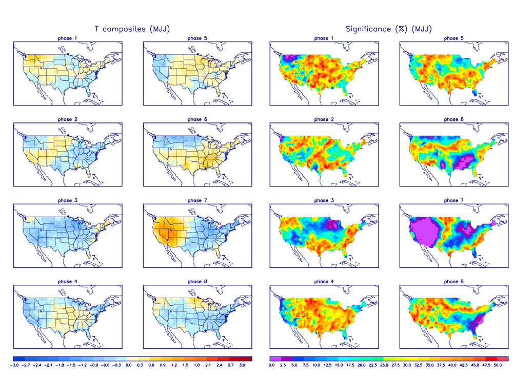
In the header above, I made mention of a cool down about the Middle of June. Today I believe that it is going to occur sooner, and I will show and tell you why. In the discussion below, there is reference in regard’s to the RMM phase space that deals with Tropical forcing. The MJO, “Madden and Julian Oscillation” Phase Space chart is spiking with a very significant signature over the Indian Ocean over the next 10 days. The CPC last Tuesday indicated that they did not believe that the MJO itself was causing the spike, because for 1, the MJO is not all that strong this time of the year and #2, if I am correct, the speed at which it is moving. It was indicated that the rise in convection was more due to the low -frequency state of either an Atmospheric Kelvin Wave or the ENSO state itself. No matter, this strength of amplitude and convection over this particular area of the Indian Ocean should cause the PNA to Flip Negative with a long wave Trof setting up along the west coast by early Week 2. That means cooler then normal temps over CA , wind and a chance of precipitation around the 7th to the 15th of June.
Look at the Current MJO RMM, then the composites for June in the forecasted time frame.
RMM; (MJO Phase Space): http://www.cpc.noaa.gov/products/precip/CWlink/MJO/CLIVAR/ECMF_phase_51m_full.gif
Composites for June: http://www.cpc.ncep.noaa.gov/products/precip/CWlink/MJO/Composites/Temperature/MJJ/combined_image
The Dweebs will update on the progress of all this, once the global model ensembles really latch on…
Dr Howard and the Dweebs………………………….:-)


