Brought to you by Howard Sheckter
Warmer and Wetter Systems Ahead…..Weekend Looks Great!
Thursday February 2, 2017
Update via Weather Letter Tuesday 12:00PM 2-7-17
http://data.mammothweather.com/landing/
The pattern I see developing over the next 5 to 7 days will be one that favors central and northern CA more with warmer storms and wetter snowfall. Weather systems Thursday, Friday, Sunday night and Monday are associated with a jet stream that is focused further north. So snow levels will gradually rise with time. Atmospheric Rivers are still possible over the next 7 days so precipitation prediction will be tricky, especially this far south.
I am particularly concerned about a stronger Atmospheric River, Tuesday into Wednesday night next week. That system may play havoc with the snow pack, especially over the Northern Sierra. To sum it all up, we have a few more weather systems to deal with here in Mammoth. However the brunt will be several hundred miles to the north of us and the southern portions of these systems will have both higher snow levels with weaker Atmospheric Rivers at times. It is still possible that over the crest, there may be another 3 to 4+ feet by next Tuesday. There will be much less amounts in town because of the warmer temps. Again there is a concern about the Anti Cyclonically Curved pattern, behind the Monday weather system for Tuesday into Wednesday.
The Dweebs are not completely confident that once the upper ridge sets up over the west coast later next week, that the ridge will hold for any significant length of time. However, the break will be welcomed by many!
Long Range Forecast- The next two systems that are headed our way look to bring between a foot of snow to the lower elevations of town and up to between 2 and 3 feet of snow over the crest. This is between midnight Wednesday night and early Saturday a.m.. It looks to be wet snow in the Town of Mammoth with cooling temps Friday into Friday night. The snow level will come down Friday night. This is a particularly windy system, as the upper jet axis is mainly to our north now. The weekend looks partly cloudy and breezy. There will be quite a bit of cloudiness at times with a few showers possible later Sunday, highs this weekend will be in the 40s and lows in the 20s. The Dweebs hope that this Sunday’s report for Monday a.m. will shed more light on that Atmospheric River for mid week next week, if and where it may set up. If we do get precipitation in town Tuesday and Tuesday night. Most likely it will be rain.
Interseasonal outlook:
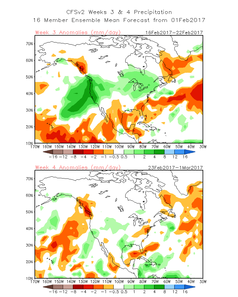
The Climate Forecast system is showing for week 3, a Massive Block, NW/SE over Hudson Bay then NNE to the Sea of Kara, Russia. The PV is forced to set up well South of the Gulf of AK about 135W to 140W with a southerly displaced Storm Track that could really hammer the central and northern West Coast….Sometime between the 16th and the 22nd of February…..Stay Tuned…. Note: This is an outlook and not a forecast. (There is a difference)
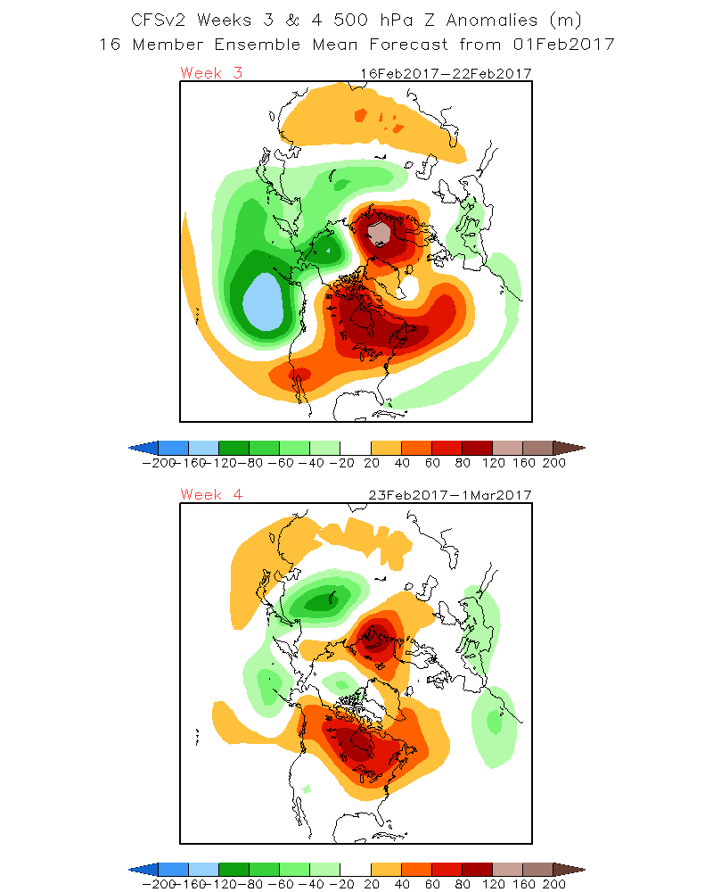
Precipitation Anomaly: