Brought to you by Howard Sheckter
Archive for December, 2018
Cold Inside Slider pattern will bring snow showers and cold temperatures to the high country…Gusty Winds over the higher elevations prompts the awareness of a Wind Chill-Factor….. Temperatures to moderate over the weekend….No Major Storms in sight….
Thursday December 27, 2018
12/29/2018 10:00AM
Thoughts about the long range….
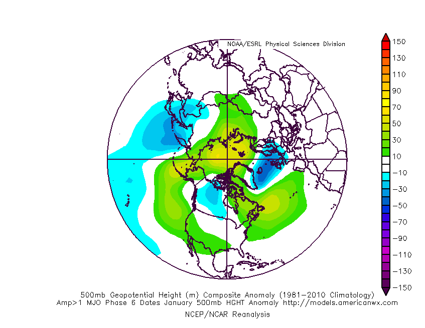
When ever I see a possible series of storms during any month of Winter in the week 2 period, IE in this case, between January 5th and the 11th, I always look to see where and how strong the MJO is. The MJO has a statistical relationship to the longer range for weeks 1 through 4. In this case the week one period falls within the MJO phase space 5 and 6 and for January, this tend to be a drier than normal period through early in the phase space 6 with heights increasing along the west coast; See: http://www.americanwx.com/raleighwx/MJO/MJO/JanuaryPhase6gt1500mb.gif
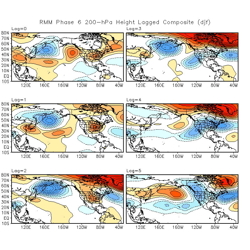
So the current Saturday 12Z run has some support for the weekend storm of the 5th of January late Phase 6). However, the ECMWF Shows a weakening MJO as it moves into this western pacific region with an increase in heights in the +PNA. It delays the storm into the week 2 period. Prind point here is that using only the GFS, the weekend storm of the 5th is a somewhat low confidence bet at this point. Going from phase 6 to phase 7 has a better relationship to storminess for CA and that comes during the week 2 period. This time of the year, the week 2 period storm track may favor Southern CA best, especially early during week 2 then further north later in week 2. SEE: http://www.cpc.ncep.noaa.gov/products/precip/CWlink/MJO/LaggedComposites/whmjo6.djf.z200composite.web.png
12/28/2018
Mammoth Weather.com picked up 3 inches of snow over night. Skies are clearing….it is cold with highs near 20 today. There is a wind chill factor on Mammoth Mt today….ware face protection….:-)
As Forecasted…A a cold inside slider is bringing snow showers and cold temperatures to our region. Temperatures are running some 20 degrees below normal for this time of the year which should be in the low 40s. Both Thursday and Friday nights lows will likley be below zero over much of Mammoth. As the upper flow becomes more NE/SE orientated today, upslope snow showers are likley with light accumulations expected. 1-3 inches. Friday will be the coldest day with highs near 20 degrees.
The Weekend outlook shows moderating temperatures that become seasonal by Sunday. Wind protected colder valleys along highway 395 are likley to experience over night lows around -10 to -15 or colder.
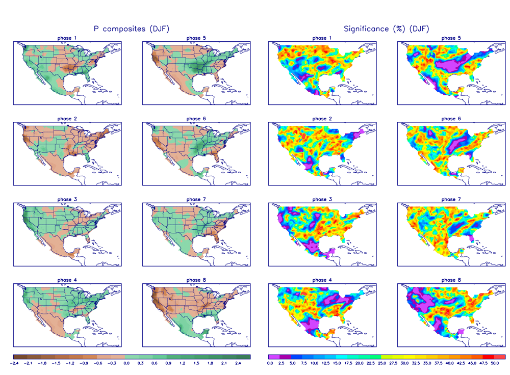
The longer range….First week of January is being forced by a strengthening MJO entering the Western Pacific. With the MJO in phase 6, it is likely to suppress storms and precipitation over California through the first week of January. SEE MJO Phase 6 composites for California (jan): http://www.cpc.ncep.noaa.gov/products/precip/CWlink/MJO/Composites/Precipitation/DJF/combined_image.png
This MJO is an area along the equator highlighted by a pulse of rain and thunderstorms. It is currently over the far Maritime Continent moving westward to the western pacific. Strong westerly wind bursts are now occurring over the Eastern Indian Ocean. See: http://www.bom.gov.au/climate/mjo/#tabs=Time-longitude In that the American GFS model and their ensembles really amplify this MJO feature to the point of +4 deviations of normal, it will be very interesting to note things like latent strong westerly wind bursts that develops in response, that possibly intensifies El Nino on a climate scale of time. However, on a shorter time scale, if the Climate Forecast system, (CFS) is correct, noting and contrary that the GFS and ECMWF appears to be much quicker and less amped, it is possible to have a strong atmospheric response on the central west coast in the form of an “AR”, sometime depending upon the speed of the MJO, during the week 3 period of January. The composites relate to warmer than normal temps for California phases 7 and 8 with a bias for precipitation in phase 7 followed by drier than normal in phase 8 then wet again phase 1. The classic MJO induced AR’s usually occur when the strong MJO crosses from Phase 8 to phase 1. The pattern can be forced by Rossby Wave Dispersion into the Pacific Basin with fast Meridional flow aloft, followed by retrogression of the long wave features over the Eastern Pacific. An extension of the East Asian Jet to the west coast is then possible. The process includes undercutting the EP ridge forcing -EPO, that transits to -WPO. it is a wait and see if the ECWMF and GFS follows suite. This of course is always a long shot, however possible…
Sensible Weather: Watch to see if: 1. we have a dry week during first week of January; followed by a possible storm during the second week of January, followed by a strong amplifying ridge in phase 8 with dryer than normal weather, followed by Pineapple express. Timing may change depending upon speed of MJO. Of course, if the current runs of the GFS and ECMWF are correct, then this post is one for the trash can.
Will Watch to see if the ECMWF and GFS falls in step with the NCFS keeping the MJO very strong and propagating it through phase spaces 7, 8 then possibly 1. The fact that the ENSO basin has not fired up convectively yet is a good sign in this respect.
Dr Howard and the Dweebs……….:-)


