Brought to you by Howard Sheckter
Archive for year 2022

Beautiful Weekend on Tap with Strong Inversions and Mono Lake Fog to continue in the Lee Vining Area until winds pick up Tuesday or Wednesday…..It will be milder over the Christmas Holiday then something to watch out for toward New Years….
Saturday December 17, 2022
12-19-22
No significant changes this morning to yesterday’s thinking. It’s a wait and see this week for next weeks mid week storm.
On another note, it’s been touted that we will have a dry January. The Dweebs are not so bullish about that this morning. The NCEP Global Ensemble System extended forecast shows a significant MJO migrating into Phase 7 the second week of January. The Dweebs believe that there is a significant chance of a “Mid Latitude Response” leading to an active pattern for CA around that time. The reasoning for that thinking is that during November, the MJO succeeded in generating a downwelling oceanic Kelvin wave, which is reducing the extent of the available cold water that the trade winds can upwell near the date line. This may have the effect of allowing the MJO to extend eastward, stronger and thus create the chance for a significant mid latitude response.
I will post RMM Graphic shortly below.
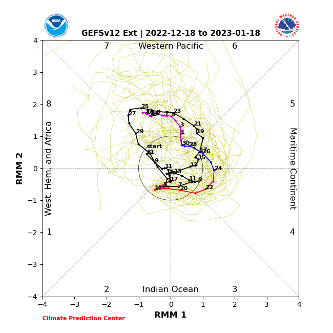

EACH LAGG IS 5 DAYS
____________________________________________
12/18/2022
The AR drums are beating stronger for Central and especially Northern California this AM for the end of the year. This would be a pattern with higher snow levels if it develops.
_____________________________
Beautiful weather can be expected more often than not between today and Christmas Day. Yesterdays high was in the mid 30s with today reaching the upper 30s. The low this morning was 8 degrees. However, in the colder valleys, lows have been -8 in the community of Crowley Lake -12 in Bridgeport. As a note, at 11:00am this morning, it was still only 4F degrees at both Crowley Lake and Bridgeport! Burr!! In the Community of Lee Vinning at Mono Lake have had nights and mornings of Freezing Fogs. Mono Lake is a salt lake and its waters are open all year!
The Guidence……
We still have an upper high in the Gulf of AK. There is a remaining weak southern stream over the eastern pacific that includes a weak upper low off the CA coast. That low will kick in tonight and outside of high clouds, no precipitation is expected from it. The Upper High will develop into a closed Anticyclone toward mid-week next week north of Siberia, eventually sagging south over that area and dissipating after Christmas. The downstream effects will be a deepening Trof near the dateline and a building and progressive upper ridge over the far eastern pacific. As the Ridge sharpens early next week, a short wave trof slides south through our area bringing the slight chance of some snow showers Tuesday evening. This pattern is associated with a NW Jetstream into the pacific NW. It will get breezy in Mammoth later Tuesday into Wednesday with a period of wave clouds as well! The upper jet is well NE of us by Wednesday night and Thursday. By Thursday night, the upstream ridge builds into CA while a short wave trof comes through the upper ridge early Friday. High clouds are certainly possible Thursday and Friday. Thereafter, the upper ridge strengthens Saturday into Christmas Day Sunday. Our warmest daytime temps may reach the low 50s Saturday/Sunday/ Lows at resort levels will rise to the 20s. Its going to be a beautiful holiday weekend!
Week 2:
This is where the pattern Dicey…..
This morning, there are a lot of unknowns about the weather outlook toward New Years. More details will become clearer by Christmas.
This is what were dealing with…..
The new guidance and an increasing number of ensemble members are breaking down the Siberian block toward the middle of the week after Christmas Day. That block keeps the long wave trof near the dateline and the downstream ridge over the west coast. When the block breaks down, it will allow the storminess over the western and central pacific to progress east. Depending upon how strong the west coast ridge remains, that will dictate where this energy will go. Some area of the west coast is going to get Clobbered! I can not say at this time where it is going to happen. But there is going to be the potential of a Major Atmospheric River associated with it! This is a warmer pattern with higher snow levels.
The most likely area will be the Pacific NW, however some model runs show it into Central and Northern CA between the 27th and the 30th. This mornings GFS deterministic run had a 190 knot upper jet at 250MB extending from just west of Japan all the way to the eastern pacific. Although this pattern does have some limited MJO support, its way way to early to be concerned.
More later next week or sooner…
Dr Howard and the Dweebs…………………….:-)


