Brought to you by Howard Sheckter
Very Quiet Week Ahead with it being Very Mild the first half….Then a few inside sliders during the 2nd half to chill it down some…..Long Range Models looking Pretty Dry for much of November……
Monday November 11, 2013
Quick Update Tuesday Afternoon:
The new 18Z GFS is trending back to an inside slider while the 12z run of the EC is most consistent as a Great Basin slider.
So for the time being this is a cold dry system with some snow showers at best for the weekend. It will definitely be cold!
—————————————————————————————————————————–
Tuesday AM UPDATE
12Z Tuesday GFS just finished its run. It shows the strong subtropical ridge centered west of Cabo San Lucas amped north to the front range of the Rockies. This upper ridge will retrograde in the coming days and redevelop out about 140west. The results are a sharp cold short wave that digs out of western Canada and brings some of the coldest air of the season….and possibly some light snowfall. Once again like the system in October, the Precip will depend upon if the upper jet gets out over the Water as it digs south. So Yes…there is now a chance of snowfall, at least according to the new 12Z GFS run. However, the earlier runs did not show this system this far west and the EC either. So well have to wait until we see more model runs to see if this change sticks. The New 12z GFS paints about .5 to .6 inches of QPF over our area for several inches of snow Saturday/NGT.
For now, try not to get too excited…..as again this is only one run of an ensemble of dry runs. What is positive, is that Saturday is only 4 days away and so this change that is occurring in this model, time frame wise, is more significant.
Dr Howard and the Dweebs…………………………..:-)
Tom’s Corner:
Long wave pattern becoming a little more receptive to energy reaching the west coast by this weekend as mid pacific closed low north of Hawaii weakens thus allowing less destructive phasing or deflection of cold air advection (ie digging) into western US via back door cold front or slider. Also cold trough over eastern US ejects ewd into north Atlantic creating an excessive wavelength to allow more troughing over Western US as an adjustment wave. An incipient wave forms off Japan on 00Z 13th with energy reaching west coast using Hovmoller timing of 10 deg long/day or 4 days later on 00Z 17th late Saturday into Pacific Northwest and early Sunday into Great Basin.
Interesting to watch this energy propagate via tightening gradients and cold air advection over western Canada and off BC coast. Latest 12Z GFS latches onto this energy and carves a deeper trough further west over California than previous runs. Will be interested to see if ECMWF and ensembles begin to trend toward this deeper and colder system digging over the area this weekend. While the effects on sensible weather may be in question… what is certain is much colder temps by Sunday with a chance of snow showers or more depending on how far west the upper jet and cold air pool aloft moves over water along the west coast. another low develops off Japan near 150E on 00Z 17th with energy forecast to come across west coast longitude 00Z 21st. This next slug of energy may be deflected well to north if long wave pattern reverts back to normal PNA (west coast ridge/east coast trough). Keep an eye on the long range ensembles for a consistent trend or converging solutions.
Tom…
Thanks Tom for your contribution….
The Dweeber….
_______________________________________________________________________________________________________________________________________________________________________________________________________________________________________
Monday Afternoon Outlook:
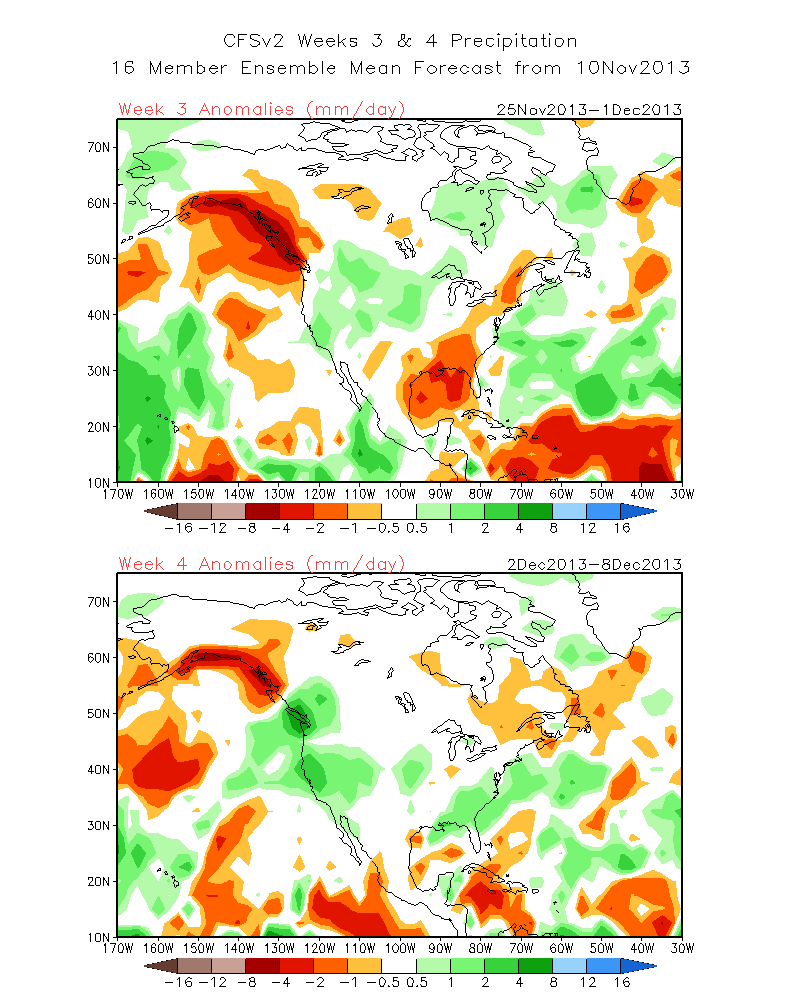
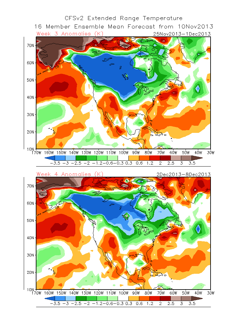
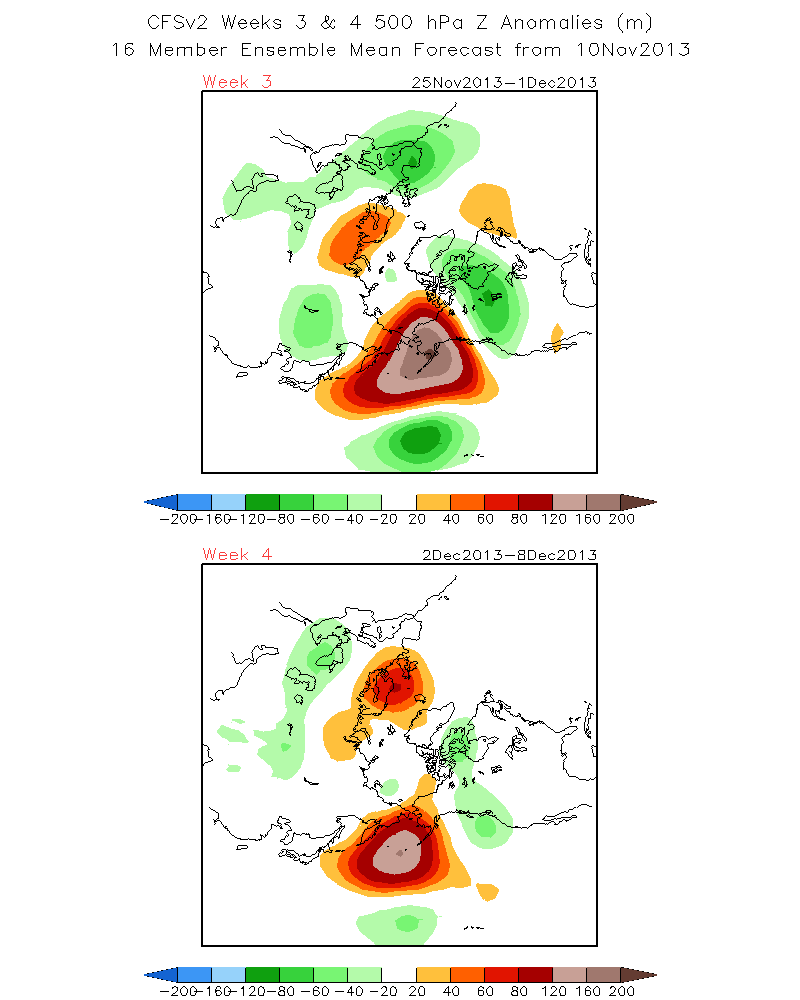
New CFS finally updated. If you want to believe this stuff…this is for you! Actually, in its defense, it accurately forecasted the big snowy December last year, back in early November.
The Climate Forecast System is calling for a wet last week of November and a wet first week of December……
The temps are Seasonal which mean snow not rain.
What is the most interesting is how the models do it. In looking at the 500mb for weeks 3 and 4 you will note a continuation of the block central Pacific block. However it appears to be both stronger and further north. -(EPO) The AO and NAO appear to be in positive mode which works for the Pacific Block better…..and so that would bode well for us. Additionally, for week 3, the minor block is over Scandinavia. (Not too exciting) but week four looks especially interesting as it is both stronger and just east of Iceland. (Nice excessive wavelength!)
We’ll see if this forecast holds as we get closer to that time frame.
I will post it here for all of you.
SEE:
Precip http://www.cpc.ncep.noaa.gov/products/people/sweaver/cfs_fcst/images1/wk3.wk4_20131110.NA.gif
Temps http://www.cpc.ncep.noaa.gov/products/people/sweaver/cfs_fcst/images1/wk3.wk4_20131110.NAsfcT.gif
500MB http://www.cpc.ncep.noaa.gov/products/people/sweaver/cfs_fcst/images1/wk3.wk4_20131110.z500.gif
(Negative Phase of the Eastern Pacific Oscillation)
_____________________________________________________________________________________________________________________
A bit over a week ago there was lots of promise for a major change to a wet pattern for Northern and Central Ca. However, the models for whatever reason got it wrong. What weather enthusiasts’ have to remember, is that philosophically, weather is perfect. What happens today or next week is exactly what is supposed to happen. It is man’s inability at this time to not have all the information for the models to get it right all the time! The good news is that (The Models) are getting better every year with more and more improvements. As examples, Today’s 3 to 5 day models are nearly as good as days one and two 15 years ago. Today’s 6 to 10 day outlooks are probably as good as todays 3 to 5 day forecasts, 15 years ago.
So it is all moving in the right direction. Additionally, during the Spring and Fall, models have to deal with the change in the differential heating of the oceans and the continents. The models use different equation’s to base there calculus on in the Winter as compared to the Summer. That is why model verification is so much better in say January and February and again in the Summer than October/early Nov or March. Additionally, in the Fall you have a big factor going on as we have all heard recently…….Typhoons in the Western Pacific. They can totally change a long-range outlook with in a day, if they change direction and re-curve to the north or phase different because of upstream short wave timing. Lots of variables.
Obviously there were too many and the best forecast long-range models blew it big time……It happens…..but much less frequently then 10 years ago.
As long as folks want to know what the weather is going to do a week or two away, there will be outlooks for them to find out. However, remember, an outlook is different then a forecast! The ability to get it right is much better 5 to 7 days out today then in the 6 to 10 day period.
Forecast Discussion:
The Upper ridge at the dateline has found a home for a while. The wavelength of 60 degrees from ridge to ridge has set up some fine weather for most of California. There is a stalled out storm off shore that will spread some subtropical moisture through the ridge over us. Lots of high clouds are expected the next day or two. Temperatures will remain much warmer than normal for the next few days. Low 60s and 30s.
The second half of the week will be dry as well. However, the upper height anomaly that is currently anchored out at the dateline will weaken as an eastern pacific ridge re developed far enough west to allow a weak inside slider pattern. This pattern will bring enough cooling for better snow making conditions and possibly a few snow showers later in the week. By Sunday, highs will be back in the low 40s.
The Western Hemispheric pattern is not showing any significant high latitude blocking. Teleconnections are pretty weak on each side of zero. So a polar recharge is going to occur for a while.
The 21 day cycle I used before the long-range CFS was available would suggest not much change in our weather until toward the very end of the month. That is contrary to some California forecasters that painted about 6 feet of snow on Mammoth Mountain for the Month of November. Maybe well get it all the end of the month? Will check with CPC and report tomorrow……
PS Some nice Satellite picts showing long wave trof off shore and short waves rotating to the NE bumping into west coast ridge…
Dr Howard and the Dweebs……………………………………:-)


