Brought to you by Howard Sheckter
Variable High Cloudiness expected for the MLK Weekend….Temperatures to Remain Mild through the Holiday….Then Expect Cooler Weather Tuesday and Wednesday…..
Friday January 16, 2015
Friday 1:25PM Comments….
Just had a look at some of the key teleconnections this afternoon.
The PNA is currently positive and is why we have such strong ridging over the far west. However, in looking at the PNA by the 26th…. It is interesting to note that the 12z 1/16/15 ECMWF on the 26 of January has the PNA index at about -2.5 Sigma from neutral. What I like as well is that the new GFS Upgrade T1534 12z run today has the PNA at -2 Sigma. The old GFS has been retired as of early this week. As far as the EPO index, the ECMWF goes from +2 Sigma today to -2 Sigma but the GFS Upgrade goes from +2 sigma to neutral for the 26th.
The (PNA) is the Pacific North American Pattern and in its negative phase is usually associated with more trofing over the far west. The (EPO) eastern pacific oscillation is associated with heights building over Alaska further west and is often times associated with retrogression. So things maybe moving in the right direction during the last week of January into February.
——————————————————————————————————————————————————————————————————
The updated forecast for the MLK holiday weekend shows variable high cloudiness through Sunday with Gusty Winds at times over the Sierra Crest, breezy at times in the Town of Mammoth. High temperatures will range in the 50s at resort levels and 20s and 30s at night. The further outlook is dry for the most part and cooler as well.
WX Discussion:
A blocking ridge of High Pressure aloft will remain off the Southern CA coast through the middle of next week. The upper jet favors Extreme Northern Ca, OR and WA. With the upper jet this morning over Northern Ca, gusty winds are occurring over the Mammoth Crest to 60 MPH. It is likely to remain quit breezy today and tonight over the crest. Another short wave will move onshore later Saturday. This will bring more breeze to the upper elevations as well as more cloudiness to the Mammoth area. However, these clouds have little in the way of moisture and outside of a slight chance of a shower, precipitation will remain 100s of miles to the north of us.
The short, medium and long-range shows well below normal precipitation through the end of January. However, with that said, there are increasing signs that during the last week of January and into February, that retrogression with the upper blocking west coast high and a gradual weakening of the Subtropical Eastern Pac Upper High will occur. This is according to both the new T1534 now operational GFS and latest runs of the ECMWF…32 DAY 51-MEMBER ENSEMBLE CONTROL (EPS) Note: There is no established pattern yet, just retrogression with many of the ensemble members.
PS There is no truth to the rumor that it will be dry through Mid February because the forecast skill for weeks 3 and 4 is no better than about 50/50.
Dr Howard and the Dweebs………………………………..:-)
Climate:
On a bright Note….
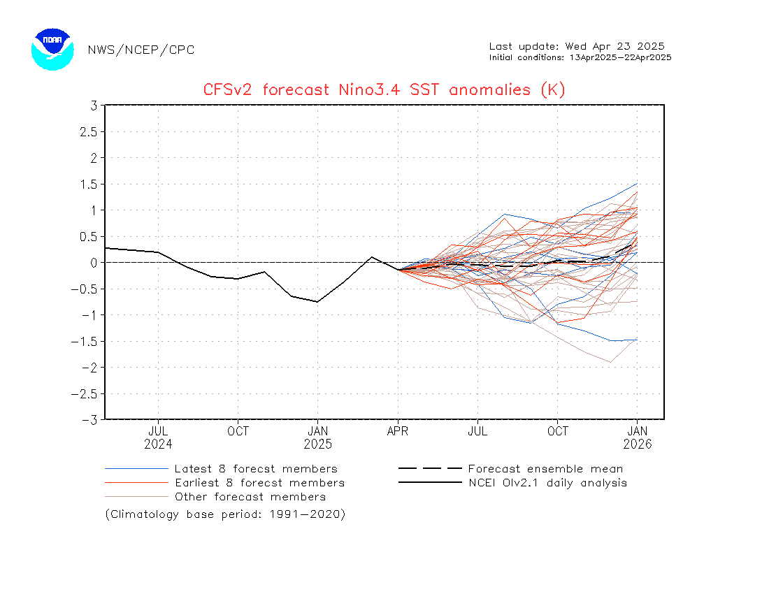
Check out the latest CFC Forecast:
CFSv2 Forecast of Weekly Climate Anomalies
Wouldn’t that be nice!
See: http://origin.cpc.ncep.noaa.gov/products/people/wwang/cfsv2fcst/imagesInd3/nino34Mon.gif
Some Unofficial Mammoth Pass information provided by amateur Hydrologist Bob Sollima “Back County Bob” as it pertains to local history….
According to Bob…..
“At this time, we are about even with the 1991 year mid-January. 1991 was the second worst drought on record (for Jan-Feb)…then the March Miracle that year which propelled the water content to 75% of average at (water) year’s end on April 1st. If Mammoth Pass does not pick up any additional precip by the February 1st (2015) survey, we would be in danger of having the lowest February survey result in history…even less than Feb 1977. The 1977 winter at this location only gave us 8.6 inches of water content at April 1st TOTAL. As the Pass sits now, we have about 4 inches of water stored in the snowpack there…about 50% of what was there this time last year (2014) & about 50% of what we had at this time in (2012). 4 inches of water content (at this point in time) equals 1977. Average for this date is about 25 inches water.”


