Brought to you by Howard Sheckter
Wet Pattern to continue through Tuesday afternoon with very significant precipitation Totals for the west side and sierra crest…..much colder system to quickly move through Christmas Eve……MJO is making all the right moves!
Monday December 21, 2015
Tuesday: 10:20AM
Mammoth Moutain picked up 2 to 3 feet of wet snow…..
A break Wednesday withy breezy conditions and cooler then a Platinum Powder snowfall Thursday and Thursday Night….
Update at 12:00PM
—————————————————————-
8:15PM Monday:
Were doing really Well! temperature now 31 degrees at 8200 foot; CRFC just updated with 4.00 of QPF for Yosemite by Tuesday afternoon. The IOP will be from 10:00PM to 4:00Am so bigger snows on the way!. That will be the period of the most intense precip so hang in their baby!
4.00 6:1 = at least 24 inches of cement. But wait!! The temperature at the summit is 21 degrees! That’s better much better than 6:1! One things for sure…the god squad up on the hill will be very busy in the AM. Just try to sleep-in with the 155 MM Howitzers going off in the morning…..!!!
Platinum Powder alert will be postponed until the late AM. Dweebs want to see 4 more runs….
The Dweeber…………………………………………………
We have had wetter storms than this one, but this is fairly wet. The nose of the hose hits the sierra tonight into Tuesday morning. Wet snow will continue in town and not as wet snow will fall on Mammoth Mt. Actually it is great news for the sierra snow pack as 3 to 5 inches of water is forecasted at snow to water ratios of about 6:1 through Tuesday PM. About 2 feet of sierra cement is expected by Tuesday Evening over the crest.
Winds have been ramping up over the higher elevations, with the freezing level slowly rising as well. The freezing level is expected to peak out at about 8500 Tuesday Midday with a snow level of about 8,000, before falling Tuesday night. After a break Wednesday, a very cold trof will push through the area causing possible local blizzard conditions. I am expecting 7 to 12 inches of snow from the Christmas Eve storm over the upper elevations….at snow to water ratios of 15:1 to 18:1. In town, lesser amounts are expected, possibly 4 to 7 inches. According to the CRFC, the freezing level is forecasted down to 1500 feet by Friday AM That’s a snow level of 500 to 0. But of course by then, there will not be much of any snow falling Friday Christmas Day, contrary to earlier forecasts. The system is forecasted to move through….Too fast. Nevertheless, some fine powder will be for the tasting!
Saturday looks Fair into Sunday PM…..
A little MJO never hurts:
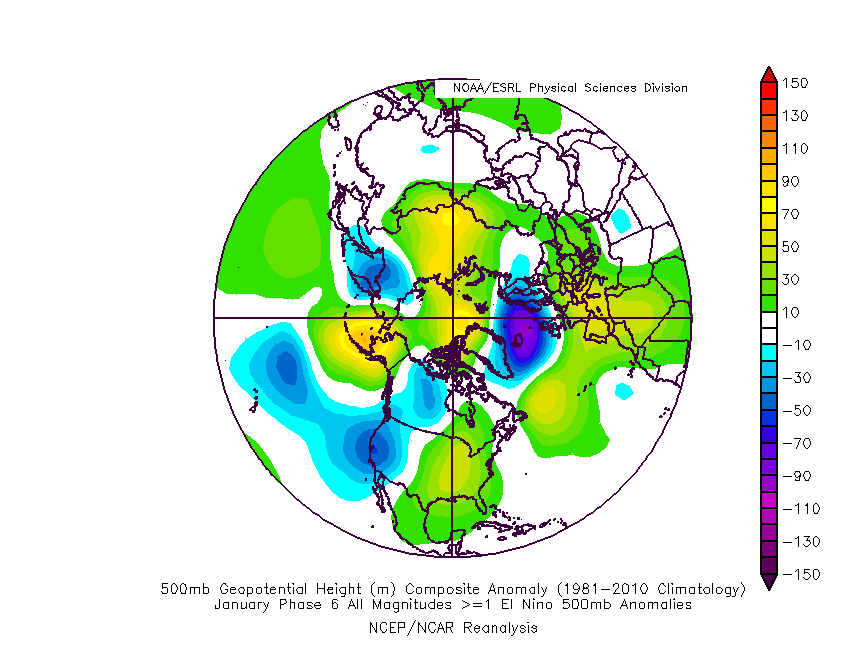
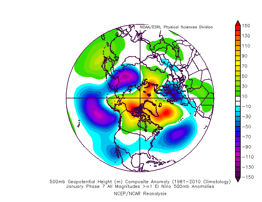
If you look at the Classic El Nino forced wet weather pattern for California, it is highlighted by the positive phase of the PNA and an extended low height anomaly between Hawaii and the Gulf of AK. You have to have anomalous above normal heights at 500MB between Eastern Alaska to Western Canada to act as a block. The westerlies are thus forced to duck under the block and the hyper extended subtropical jet through Baja, helps the pattern pull through CA. That has not happened yet…..
Will it?
It is sure beginning to look like it. So what needs to happen?
- We need some MJO in the right place. Like Phase 6 and especially 7. An interesting reaction happens when the MJO moves out the Indian Ocean toward the western pacific. The PNA flips from Negative to Positive at about 130 East. Heights rise along the west coast and especially over the pacific northwest.
- If you want to see why I feel that the PNA is getting ready to flip, look at the MJO forecast by the GFS and its track and then look at the composites for January during an El Nino and see the loading pattern for the teleconnection.
- The Forecasted MJO: http://www.cpc.noaa.gov/products/precip/CWlink/MJO/CLIVAR/NCPE_phase_21m_full.gif
a. Phase 6 composite 500MB Heights in January : http://www.americanwx.com/raleighwx/MJO/MJO/JanENMJOphase6gt1500mb.gif
b. Phase 7 Composite 500MB Heights in January: http://www.americanwx.com/raleighwx/MJO/MJO/JanENMJOphase7gt1500mb.gif
Timing?…about the end of the 1st week of January
For you Platinum Powder subscriber’s, a special discussion this evening on the Christmas Eve storm…
Dr Howard and the Dweebs…………………….:-)


