Brought to you by Howard Sheckter
Sunday Afternoon’s Analysis over CA showed weak cyclonic circulation over the interior of Southern CA with scattered mainly light shower action……Over developed conditions of extensive cloudiness over Southern Mono County leads to the unlikelihood of significant precip today unless we get some surface heating….
Sunday April 10, 2016
The main action this afternoon is confined to the more dynamic area of Arizona, that is just north of the upper jet crossing Baja along with the weakening cyclonic flow over interior Southern CA. There is strong upper divergence in that area. We are definitely into hybrid forecasting today with both dynamic forcing type conditions to the Southeast and strong daytime heating with increasing surface CAPE taking off over Northern CA. There is likely to be a lot of thunderstorms over those two areas this afternoon. Here in Southern Mono County outside of a few showers it does not look all that exciting for the rest of the day. No Deformation and no surface heating. About the only thing worth mentioning is that the Lifted’s are near 0 here and there is a small 850 convergence /250 divergence couplet showing up in the SPC over Northern Inyo County. So if the sun happens to come out long enough, we might get a shower or thunderstorm. There is certainly enough afternoon left for that…
Longer Range:
The week ahead still looks cool and unsettled through Thursday with a rather windy short wave rolling in Wednesday afternoon with the upper jet translating east Thursday morning. The closed low idea from last week is off the table. It is expected to bring light amounts of snowfall. Possibly a few inches in town and 3 to 5 inches over the top of old woolly. Now for the big news…..The idea of a series of storms moving through California for the next few weeks is off the table now. We are in that time of the year when the longer range guidance is not worth the 1’s and 0s that pop into the programs that produce week two and inter-seasonally Week 3 forecasts. This is not to say that we are done for the year. However, we go into a weak split flow pattern with precipitation driven more by weak closed lows rather than transitory short wave that bring actual fronts to our area. Deformation, surface convergence/upper divergence couplets and CAPE will play a more important role in forecasting in the weeks ahead.
The following weekend looks fair at this time and warmer…
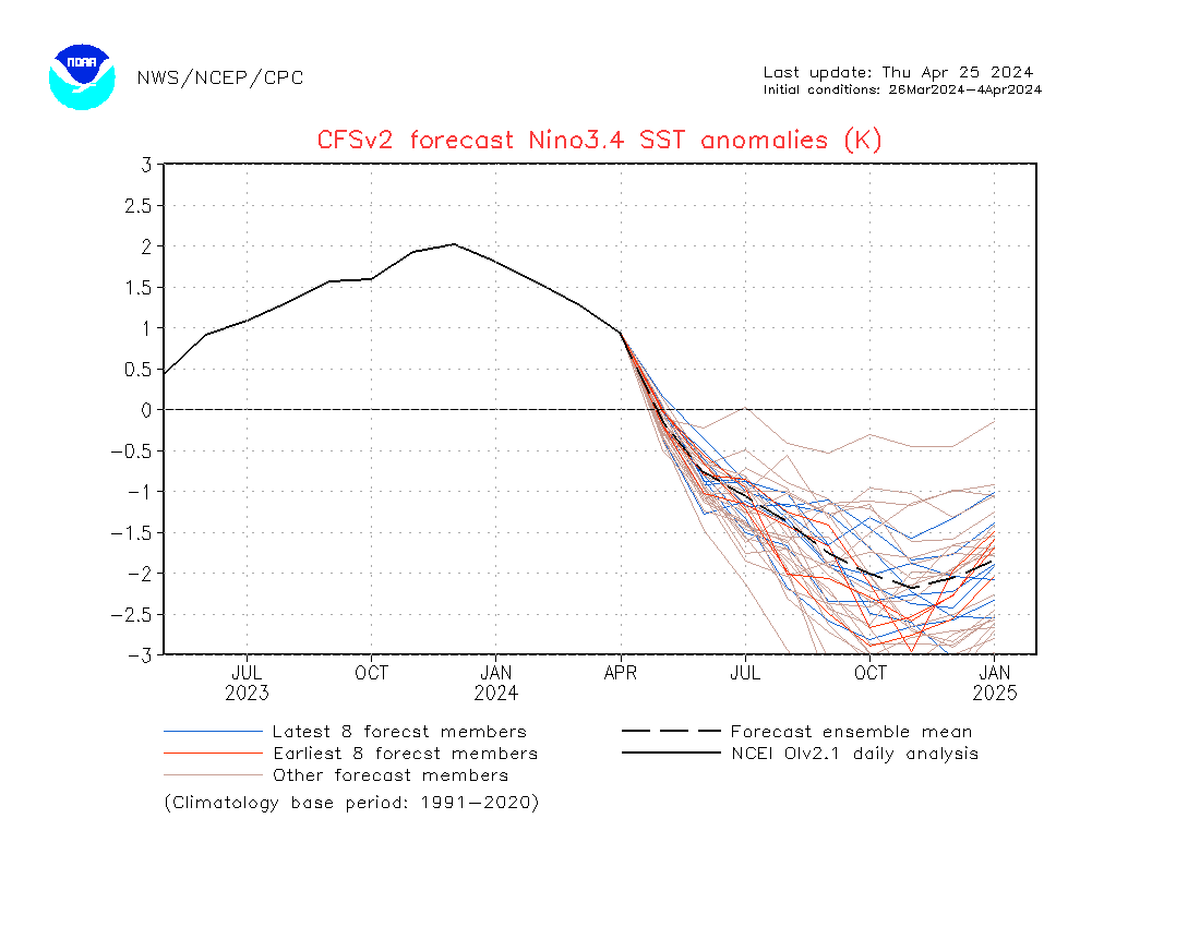
ENSO: You have to look at this!!! Could this be a whopper of a La Nina?
Check out the links below.
First look at CFSVS2 SST forecast for the Nino 3.4 region from the initial conditions between March 11th to the 20th: http://origin.cpc.ncep.noaa.gov/products/people/wwang/cfsv2fcst/imagesInd1/nino34Mon.gif
Then compare it to the latest forecast from the initial conditions March 31st to the 9th of April: http://origin.cpc.ncep.noaa.gov/products/people/wwang/cfsv2fcst/imagesInd3/nino34Mon.gif
Good Golly Miss Molly! What happened!!!
Now Check out Scripps’ ENSO Forecast for next Winter!: http://meteora.ucsd.edu/~pierce/elnino/pictures.html
WOW!!!!


