Brought to you by Howard Sheckter
Archive for October, 2019
Near Record Cold Over the Weekend supplying wind energy for the Southland today……Next shot of Great Basin energy on the way……
Monday October 28, 2019
November 1st;
The weather pattern continues dry for the eastern sierra. Stronger inversions are developing now and so temperatures aloft are not as cold. There are two global models that I usually compare most of the time. The ECMWF (euro) The GFS (american) On occasion, the JMAN Japanese (ensemble) and Canadian. (GEM)
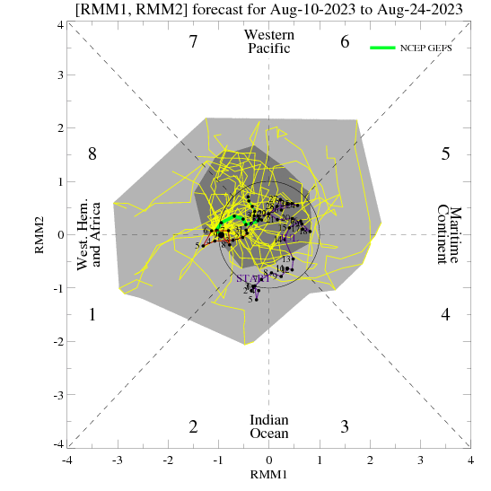
All are dryer than normal for November, The November outlook is arriving soon. The big issue here I think is the ongoing strong IOD Indian Ocean Dipole in its positive phase. It is responsible for below normal convection over the Maritime Continent to the Western Pacific. This often times will shift the tropical convection over the Western Hemi further east and as a result, teleconnection often favor a Trof in the east and ridge in the west. Not all the time, but often enough to make a difference in normal amounts of precipitation over CA. The +IOD will most likely weaken toward the end of the Winter. The European model is an air-sea coupled model and may have a better handle on the longer range this winter as compared to the GFS. We’ll see…. At the moment, the GFS has the MJO into phase 8-1 around mid month. That would be positive for a storm or two for Mammoth. Those MJO Phases often pulls the upper, Eastern Pacific high far enough north to allow some undercutting of the westerlies to the west coast. However, the ECMWF does not get it there….Thus it continues to be drier than normal through mid month. The climate model portion of the ECMWF shows a few feet of snow for Mammoth as we go from Mid Month to the end of the month. The Dweebs will keep you all in the loop on this.
Dr Howard and the Dweebs…………………..:-)
________________________________________________________________________________________________________________________________________________________________________________________________________________________________________________________________
Mammoth Residents had a rude awaiting Sunday morning as the low temperatures of the early morning did not change all that much during the afternoon. Mammoth even experienced some light snow flurry action for a time. Mammoth’s high temperature was confined to the mid 20’s on Sunday while in Bishop Ca, the high temperature nearly broke a record high-low of 49. This was a degree above the all time record High -Low set back in 1991 for the date. In Mammoth Lakes, the high was 26 degrees, possibly a record, High-Low?
The wave that pulled through Sunday morning pulled Northern Rockies cold air into our area. In back of the upper Trof and surface front, high pressure at the surface built in, and was accompanied by strong subsidence aloft. Then forced down sloping winds to the west of the Sierra and south to the mountains, east of LA created fire storm conditions to those regions.
Gradients will begin to relax today and into tonight for the high country. However, another dry cold dynamic system will push into the Sierra Tuesday, and build pressures at the surface Tuesday night into Wednesday for another Offshore Wind event, and this time, possibly on steroids for the south. The upper jet appears to be stronger with this system for Tuesday with stronger convergence aloft in the Right Front Quad of the upper jet. Once again, this is a dry system.
This looks to be the last of the Santana wind events for a while. Hopefully the last, even if that’s wishful thinking….
As far as a real snow storm for Mammoth?…..We’ll have to see what mother nature deals out for us for the middle of November…..
Dr Howard and the Dweebs…………………..:-)
PS….
Looking at the GFS Ensemble for the MJO, there is an interesting curiosity developing in the MJO RIM with 1.5 Sigma in phases 1/8.
This is the time frame during the 2nd week of November. The MJO Lagg composites suggest at least weak west coast troughing during this period in November.
This is just something to watch…….
No Relief in our dry spell with below normal precipitation expected into Early November…… Chilly Western Canadian Air to pay a visit early next week…..
Tuesday October 22, 2019
10-25-2019
Just a quick update;
Our warm up will peak today in the high country. Expect highs mid to upper 60s today…
Then a strong dry cold front will sweep through Mammoth with breezy weather Saturday night followed by a temperatures drop of greater than 20 degrees Sunday over Saturday. Highs inn the upper 30s Sunday. Lows inn the teens Monday AM. Temperatures will moderate next week…..
Looking at the climate model (longer range) The Euro shows the Central Sierra near Mammoth picking up some 10 to 15 inches of snow by Sunday the 24th of November and amounts of 30 inches by the 8th of December. Again this is a climate version of the EURO and is not a forecast, but rather an outlook over a long time scale. Will report next week at this time to see if there are any changes to this long range outlook.
More thoughts….
I had a closer look at the CPC Winter Forecast, NDJ for Precipitation.
Grab a copy of the CPC on line, print it out and look at it. Note the main bias area of below normal precip is from Monterrey CA to just north of the Northern California/OR boarder and inland to the Northern Sierra where the signal weakens as you go south down the Central Sierra. This is suggestive of a Winter-time Split Flow pattern, off the Northern and Central CA Coast, whereby storms split and favor the southern portion of the State. It suggests that the Northern Sierra will have below normal precipitation with less of a negative bias as you go south. This means that Mammoth may actually fair better than Tahoe this winter snowfall wise. Southern CA, San Diego and the Southern Sierra may do the best this winter, as far as a normal or even above normal amounts of precipitation. Cold Lows with split off from the main lows off the Northern CA coast and head south down the coast.
PS. There may be some great Tonopah Lows as well this Winter, with great up-slope snowfall for the Eastern Slopes for parts of the Central and Southern Sierra! I will look at the update in November; for December, January and February later next month.
PPS. The retracted EAJ is famous for split flow patterns on the west coast during the winter.
So essentially, the low frequency base state mimics La Ninia. However, at times, the MJO may strongly modulate the westerlies, providing an Extended East Asian Jet to the west coast…….Periodically.
The Dweeber………………:-)
________________________________________________________________________________________________________________________________________________________________________________________________________________________________________
Our beautiful weather will give way to breezy conditions over the ridges today and again the end of the week followed by much cooler weather and possibly a few snow showers during that transition Sunday into Monday. This is a common pattern in late October. Expect highs cooling to the 40s Sunday and Monday next week with lows in the teens in Mammoth Lakes Monday AM.
According to the CPC. (Climate Prediction Center) On a climate scale, the prospects for a wet winter look pretty remote this year. Their winter forecast suggests normal to below normal snowfall this winter for the Central Sierra..
Possible Reason…….A large scale circulation system over the Indian Ocean may affect the weather over the Western States this year as a Strong Indian Ocean Dipole (IOD)……. currently in place, causing above-normal sea surface temperatures in the Western Indian Ocean and below normal SSTs in the Eastern Indian Ocean and waters in proximity to the Maritime Continent. The atmosphere is responding to this boundary forcing with stationary enhanced convection observed for several weeks across Africa and the Western Indian Ocean with stationary suppressed convection observed from the Eastern Indian Ocean eastward across the Maritime Continent and into the West Pacific to near the Date Line.
This is important because if suppressed convection persists in the Western Pacific along with the absence of any organized large scale enhanced convection, the convection further east in the Pacific, tends to favor more frequent periods of a “Retracted East Asian-Pacific jet stream”. So in some ways, this may mimic a La Nina like conditions downstream over the CONUS (US). For the western CONUS, this is a drier and potentially colder than normal scenario for Eastern California. The big problem, is, where will the cold air set up. It is unlikely over the ocean, but more likely over the inter mountain west, more often than not. That will be the key out west.
Other thoughts…..
The big warm blob of water earlier in the fall off the Northern CA coast has redeveloped further west at about 143 west. This may further support sharpening ridges along this longitude for the import of cold air over the far west at times.
Solar Minimum….
The deepest solar minimum of the space age is upon us. (No Sunspots) This is often associated with more high latitude blocking. Once again, where will blocking be persistent this winter? Update later in November…….
Dr Howard and the Dweebs……………………:-)
After a Brief Warm up…Pattern to bring cooler breezy weather into our region Thursday through Saturday….The Possibility of PSPS are once again on the table…..California Heat Wave looming later next week…..
Wednesday October 16, 2019
Wednesday Evening the 16th;
Most of the global models have the MJO in Phase II with some now pushing the Phase III idea. Odds are, it going to get very warm in CA later next week…..Could be critical fire situation for Southern CA…
Overall, its looking like a pretty slow start to the ski season this year. We’ll have to rely on what Mammoth Mt lays down as far as snowfall on the ground for the first half of November….
The Dweeber……….:-)
__________________________________________________________________________________________________________________________________________________________________________________________________________________________________________
It was a nice warm day throughout the region on Tuesday as high temperatures pushed into the mid 60s…. Little change in temperatures is expected for today Wednesday. A pattern change to cooler, breezy weather will arrive Thursday with gusty winds and lower humidly. There is the possibility of a bit stronger winds Saturday afternoon, as more NW upper jet energy works its way closer to the west coast and Northern CA. Although this is not the classic NW wind event for fall, messages are already coming out from SCE about a possible PSPS situation for Thursday. High temperatures will cool some 15 degrees between Wednesday and the weekend.
Longer Range;
It’s Mid October now and getting close, climo-wise, to the shift from the continental heat source to ocean based. This change in the location of the hemispheric heat source on a large scale, in another few weeks is usually better for both visibility and model verification. (November) IE. We may be better able to see patterns on a longer time scale, emerge in the global models by November. At the moment, the big driver in the Northern Hemi’s weather is the strong IOD event over the Indian Ocean. It is one of the strongest on record. It is responsible for anomalous westerlies over the Indian Ocean and the piling up of warm warm water over the far western Indian Ocean near the Arabian Sea. It is contributing to the static current phase of the MJO in phases I which relates to cooler than normal conditions in the west. The ECMWF shows the possibly of the MJO moving east to phase two. Thus week two weather will be warmer. Phase II of MJO is less cool in the far west as the coolness shifts southeast. The important idea for our region is that with this Positive IOD ongoing, it is quite possible that we will have more dry wind episodes over the next week possibly two, depending upon what the MJO does.
Phase I of MJO in October:
There is only a weak bias for precip for Northern and Central CA in phase I during October. The some Global Models progress the MJO east to phase II during week 2 and so it is possible that warmer weather will be on the way later next week. Thereafter, it weakens into the circle of death. Will it reemerge in phase one again week 3? If it does, that phase in November, has a bias for more significant cold, wind and precipitation for Northern and Central CA.