Brought to you by Howard Sheckter
Archive for December, 2021

Cold Western Trof Shifts East This Weekend bringing a beautiful ski weekend……Another potent storm sets up over the eastern pacific next week…..
Tuesday December 28, 2021
12/29/2021
The forecast remain the same through the weekend as the current western trough gets ready to exit. One more system today whose short wave is splitting off shore will bring the lions share of precipitation to Southern CA today and tonight. Here in the high country, some 6 to 10 inches is expected on Mammoth Mt with half of that in town.
Tomorrows progs has the large scale upper trough shifting east a bit. That sends all the short waves down through Nevada. With short wave energy over land, over snow cover all the way to the Canadian border, there is little in the way of air mass modification, meaning modified arctic air will highlight our temps Friday into the Holiday with snow showers Friday. Bridgeport valley may go -20 to -25F Saturday AM. Good news is that if you Bridgeport folks want to warm up, drive up to the resort levels over the weekend as temps will be inverted! Highs in the 30s in Mammoth and June.
The trend in the longer term, IE next week is to keep the Tuesday storm, further north now. So not a lot of confidence on how much if any snowfall we may get. In the past 5 days, the ECMWF had the right idea with west coast height rises VS the GFS that was overly deep with the January 4th storm. It is now questionable if we will have a major storm here in the Southern and Central Sierra Tuesday as the models are trending that system more to the north, as the hemispheric pattern goes into transition. The transition appears to involve a break down in the north-central pacific block. Additionally the Pacific North American pattern that has been negative goes neutral. This all adds up to a milder weather trend, especially later in the week with the possibility of west coast ridging returning. Will an AR affect the west coast later next week before we ridge up? Only the shadow knows! 😉
Dr Howard and the Dweebs……………………:-)
_________________________________________________________________________________________________________________________________________________________________________
One Item about weather patterns is that they never remain for long periods in their same form. Watching the week two (fantasy charts) is one way to catch what change there will be in our outlook period. This winter so far and Fall has been very humbling for the vast majority of climate or interseasonal forecasters as this is a La Nina Winter, and as winters go, they have a dry bias in the southern half of the state. As we have seen thus far, not all La Nina winters are dry for the south west coast.
Currently, according to the CA data exchange, the San Joaquin Drainage is 170% of normal for the 27th of December. We are off to an amazing start!!
From the Dweebs Desk this Morning;
Our current frigid Western Trough has a couple more impulses to deliver. One that is bringing some wind to the high country this morning with a chance of light snow. Another that will bring light to moderate snowfall Wednesday and Wednesday evening. Some 5 to 10 inches is expected for Mammoth Mt by early Thursday AM. Daytime highs will continue in the low 20s with lows in the single digits. The cold upper trof exits Thursday, as a couple of inside sliders drop down the eastern slopes. Some light snowfall accumulations are expected Thursday evening and Friday. Beyond Friday is the skiers dream. A massive snowpack for December and fair weather. If you are reading this out of the area, this is the weekend you have been waiting for!!
Longer Range:
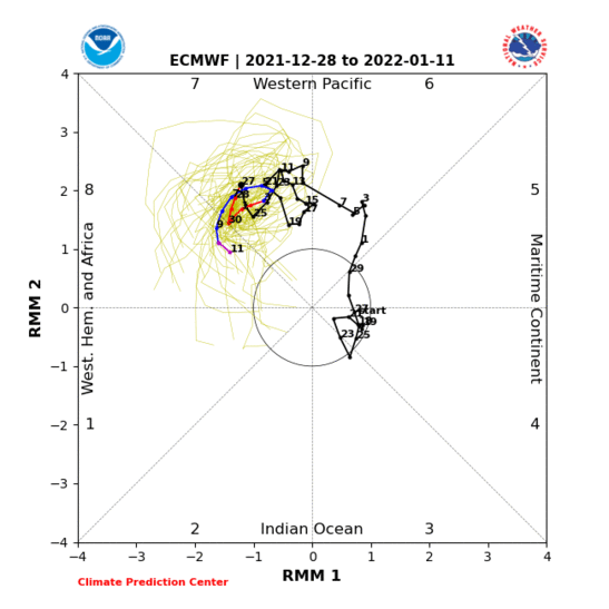
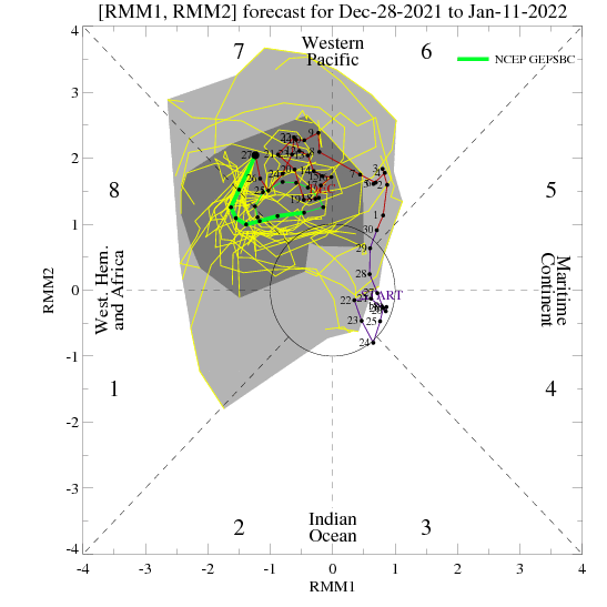
There appears to be one more storm associated with this pattern before the current upper high blocking pattern over the North Pacific breaks down. This new large scale trough is being handled differently by the global models in that the GFS is much deeper and has a stronger upper Jet for Central CA at this time. It boasts some 3 to 4 feet of snow on Mammoth Mt at distance, However, the EC brings in about 1/2 of that. The Jury will be in by this weekend. The Big News is that the pattern is going into transition. This begins about the 6th of January. The Classic Closed anticyclone shows up over Alaska. Additionally the European Global has the same Anti Cyclone Signature in the same time frame….So confidence is increasing in the outlook period. Why is this significant? In January, when the upper jet runs Supreme, the westerlies can break under a blocking pattern when the MJO goes from phase 7 to phase space 8. SEE Example above. The MJO progressing from 7 to 8 has the effect of extending the East Asian jet, thus pinching off upper high and cutting it off over Alaska. This can unleash a nasty, mild in temperature and possibly strong to extreme AR along the west coast. Keep in mind that this is not a forecast at this time, but it is definitely something to watch out for the following weekend of the 8th and beyond.


