Archive for May, 2022

Current Pattern of Warming and Cooling with wind to continue a few more weeks before Spring’s slide into Summer is Permanent


Its interesting to note that the average high temperature for Mammoth now is 65 degrees and will move climatically up into the low 70s by Father’s Day. Our Last freeze is usually Fathers Day.  Over the next 5 days the MJO will be sailing through Phases 7/8 or out over the Western Pacific with borderline moderate AR for far Northern CA on the coast. This is usually associated with lots of high and mid level subtropical moistures at this time of year. (note; in the winter, this can often mean stronger AR episode’s) This weekend’s weather will be no exception with a little cooler weather, breezy conditions and lots of cloudiness, and a chance of showers Saturday night and Sunday.  The Dweebs see more transitory migrating weather systems, while keeping the upper jet to our north.  Not much cooling from these systems is expected as compared to the one that affected the Central Sierra over the Holiday weekend, but wind yes!

Looking at the ECMWF model, for week two, it brings in quite the heat wave to the far west around the 10th. The GFS on the other hand has good rising 500mb Heights earlier week 2.   This tells the Dweebs that next week could get pretty warm at some point with Bishop reaching up to 100 for the first time this year, next week. With all that said, it is unlikely to last as one more significant cool down is probably in the cards before we head into Summer.


Local Weather beginning with today will offer light breezes in the afternoon today with a more pronounced Zephyr Wednesday afternoon and evening and possibly Thursday. It will be sensibly warmer tomorrow Wednesday and Thursday as low 70s are expected, then cooling to the low to mid 60s by Saturday with lots of high clouds and yes…Wind!


The following week looks a lot warmer with more Summer like weather….
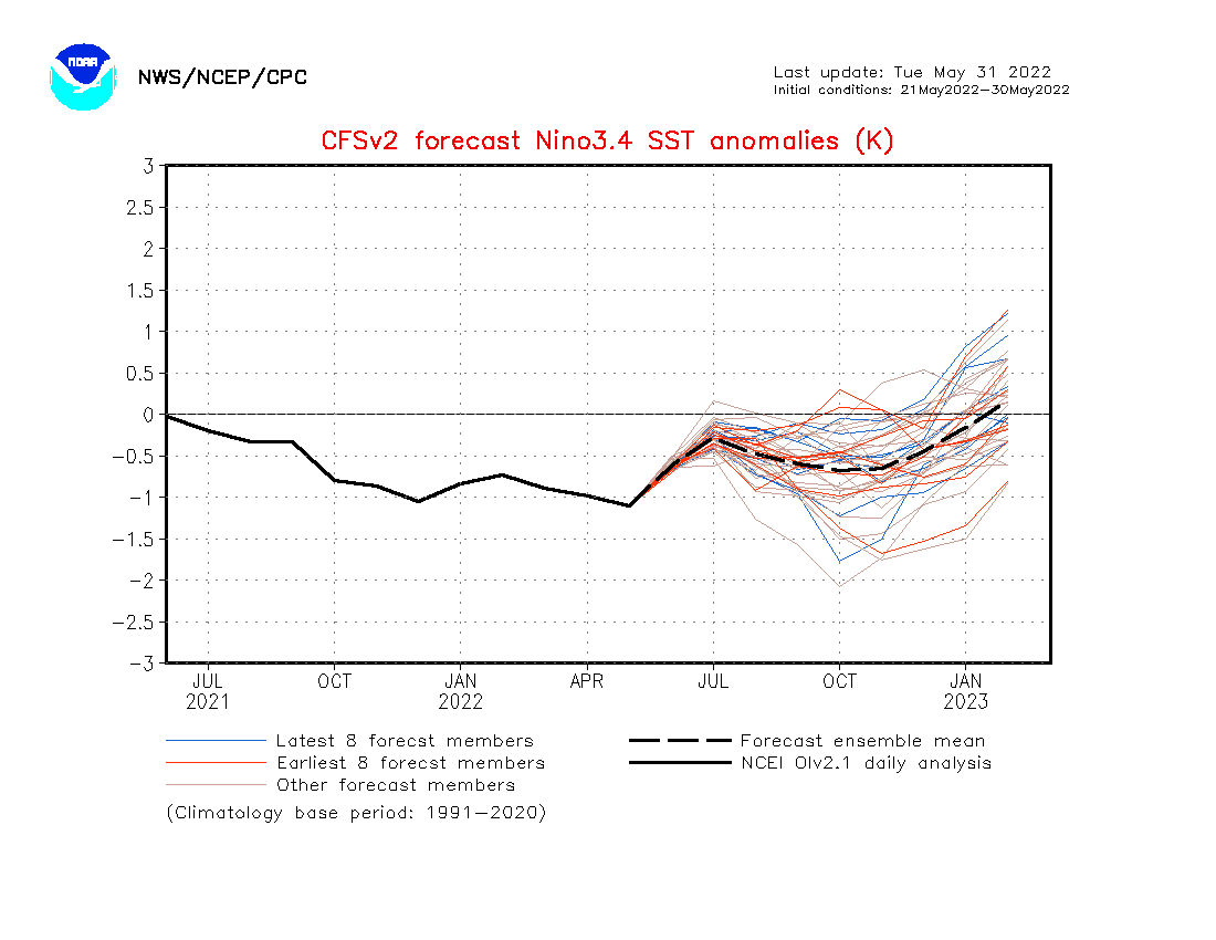
 

ENSO:

The CFS continues its trend in ending La Nina by the end of the year. The new updated IRI will be released on the 19th of June,  It will be interesting to see how all the other models chime in on ENSO.  The Dweebs would like to see La Nina gone and ENSO neutral conditions develop in December.  I think that would be encouraging for more water for California. Next Winter!


Dr Howard and the Dweebs……………………….:-)


The current warming trend continues in the High Country through Mid Week…Then cooler, windy, unsettled weather expected over the Holiday weekend

The next couple of days will be Summer like with highs in the mid to upper 70s today and Wednesday…

The Progs continue to show a progressive pattern with the next upper height anomaly progressing toward the coast today anti-cyclonically. As a result, expect today Tuesday to be the day with the least amount of wind in the high country with high temperatures approaching 75 degrees. Tomorrow Wednesday will be a day with more going on weather wise. 1st, the upper ridge progresses into Nevada during the day. This initiates southerly flow with a boost in temps while stability indices weaken.  Increased laps rates and high mid July like sun will initiate convection, while a convergence zone sets up due to increasing southerly flow. This will result in lots of cumulus clouds in the afternoon Wednesday and a 20% chance of Thunderstorms. (Isolated tsrw) mainly afternoon and early evening.

By Thursday, our upper ridge pushes into the Rockies, while a trof of low pressure approaches the Pacific NW.  It’s what’s behind this upper trof that is of interest for the upcoming holiday weekend.  The global models have been touting for over a week the possibility of a west NW jet affecting Mono County over the holiday weekend.  the current thinking is; 1. This jet is of respectable strength of 140 knots at 250MB. 2. Its axis remains north of our area through Saturday night. This is the windy area of the jet while antecedent conditions remain warm. The Jet core translates south into Mono County Sunday, so wind’s will continue at least moderate Sunday with cooling into Monday. Amplification in the upstream pattern also occurs Sunday, so that the next upstream jet-let digs the upper trof far enough south for the upper jet to reach Mammoth on Monday. That is the best day for both max cooling along with the slight chance of showers will be Monday. The weather system moves east Monday night into Tuesday with warming temps Tuesday into Wednesday next week.


Dr Howard and the Dweebs…………………………:-)

A beautiful weekend for the high country with low 70s at resort levels expected…..

With the upper jet pushing back up in the the pacific NW and moderate 500mb height rises currently occurring over CA , Mammoth Lakes high temps will climb into the low 70s this weekend with overnight lows in the upper 30 and low 40s. It will be a great weekend for all outdoor activities, especially with the absence of any significant wind.  Little change in the weather is expected other than some cloudiness this Sunday/Ngt.   The next significant change will bring mainly high clouds, (Wave Clouds) to our area next Thursday and Friday along with Moderate to strong Winds. It this point, some ensemble members are showing a slight chance of showers……Update later.


Climo:

There are some hints of the Continental high developing for the first time this year, as early as the end of this month but more likely by mid June.  Although Father’s Day is climatically the last freeze in the Mammoth area, this year it may come a bit earlier….

The 90 day outlook for the Summer Months of June July and August suggests a more active Monsoon season over AZ with above normal rainfall. Southern NV may be included somewhat, as well as the Southern and South Central Sierra according to the EURO seasonal forecasts….


ENSO;

The latest information from the CPC is that odds are good the La Niña conditions will continue through the Summer and to a lesser degree through the Fall.  With that said, as we move beyond the Spring barrier for ENSO forecasting, there is beginning to show up a bias toward ENSO neutral conditions by January 2023. See graphic below.  SSTA’s are actually colder at this time this year than the last two Springs.

If and this is a big if, ENSO neutral conditions develop during Jan, Feb and March, that may turn the pattern in the west, wet at some point, as the incidences of AR’s tend to increase when the MJO is in favorable phase space 7/8 during ENSO 3.4 region SSTAS are between -.5C and +.5C

There is likely to be some strong hints if we are moving toward ENSO Neutral conditions as there would be increasing MJO activity along with Kelvin wave action pushing warmer waters underneath the surface through the Central Pacific this Summer and or Fall.

Here is the latest Update from the IRI/CPC a few days ago.  https://iri.columbia.edu/our-expertise/climate/forecasts/enso/current/

Although La Nina is favored, the graphics from both IRI and the CFSv2 suggest the possibility of ENSO becoming Neutral by years end. hopefully this is not just wishful thinking!


Dr Howard and the Dweebs………………:-)