Brought to you by Howard Sheckter
Next Storm System to bring Moderate Snowfall Sunday with gusty winds and cooler temps….Remainder of the week looks dry until next Sunday……
Friday February 3, 2023
2/4/2023 Saturday AM Update
For our weekend storm, it appears that most recent model runs have continued the trend of Beefing Up the snowfall predictions. Here in Mammoth, a good two feet is now expected above 10,000 feet and over a foot in town by Sunday Evening. The storm is moving in sooner today with the Winter Storm Warning beginning now at 7:00PM instead of 10:00PM. The good news is that the storm will exit sooner by late Sunday afternoon instead of Sunday Night. Heaviest snowfall will be between Midnight Tonight and Sunrise Sunday AM. Expect snowfall to continue throughout the afternoon Sunday. For today Saturday, expect winds to ramp up sooner and throughout the day.
Although a dry day is expected Monday, it will be windy over the Sierra Crest in the morning and quite breezy over the lower elevations out of the North, then shifting from the NE in the afternoon. That favors the Sierra Crest as far as strong winds with diminishing wind for the lower slopes during the day as again, the upper flow becomes NE. Tuesday will dawn with calm winds and it will certainly be a Blue Bird Morning. A storm moving through the Pacific NW will kick up moderate wind again during Tuesday afternoon. Tuesday’s high will near 40.
Strong Short Wave Ridging is expected Wednesday afternoon through Friday afternoon. So winds will be greatly diminished during this period with daytime highs 45 to 50 in Mammoth! Some excellent Blue Bird Weather both Thursday and Friday!
This mornings 12Z GFS shows the next Storm System digging south, west of 125W Friday Night and Saturday. Wind’s will come up along the Eastern Sierra Saturday afternoon. The GFS has this trough almost cutting off Saturday afternoon while the ECMWF is showing a cut off low off shore. The GFS model shows the upper Jet favoring the Southern Sierra and Southern CA for mainly light snowfall for Mammoth Sunday night into Monday.
The European model really slows down the storm as the Upper Trof becomes cut off from the westerlies, Saturday afternoon into Sunday night. It appear to be waiting for the upstream kicker short wave to couple with. This delays the storm for California until Monday.
As a side note, the upstream kicker dives into the back side of the cutoff, and lifts it NNE into California, Monday afternoon the 13th into the 14th. This scenario focuses the most moisture and vertical motion into the Central Sierra whereby Mammoth becomes more of the Bullseye for this storm. Additionally, well have to see what the Kicker System does beyond that time frame. Stay Tuned! The models should get into better agreement over the next few days….:-) “It can go one way or the other”
The Dweeber……………………….:-)
___________________________________________________________________________________________________________________________________________________________________________________
It was a cloudy and breezy Friday morning as a weakening storm brushed the Mono County High Country. Tomorrow morning looks pretty nice until the winds come up in the afternoon ahead of the next storm system that may bring snowfall as early as Saturday Night. The NWS has a Winter Storm Watch for this Late Saturday Night.
A moderate snow storm is expected through out the day Sunday before its exit Sunday night. This looks to be the last significant storm until weeks end. Snowfall amounts will be in the 15 to 20 inches range on Mammoth Mt while amounts in town look to be around a foot. Snow to water ratio will average 10:1 on Mammoth Mt. (Average)
Highs on Sunday are expected in the low 30s in town.
A strong ridge ridge of high pressure builds in Tuesday and holds through possibly Friday next week as shown on this mornings 12Z GFS deterministic run. If this works out….This ridge should send high temperature’s warmer than any day so far this year. This means high temperatures possibly into the 50s in Mammoth later next week.
There is a possible pattern change to more of an active one, developing next Saturday with clouds and wind. Superbowl Sunday may be Snowy… Sorry for the folks that have to plow during a Snowstorm. Lets hope the weather maps change!!!!
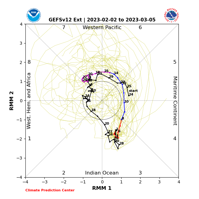
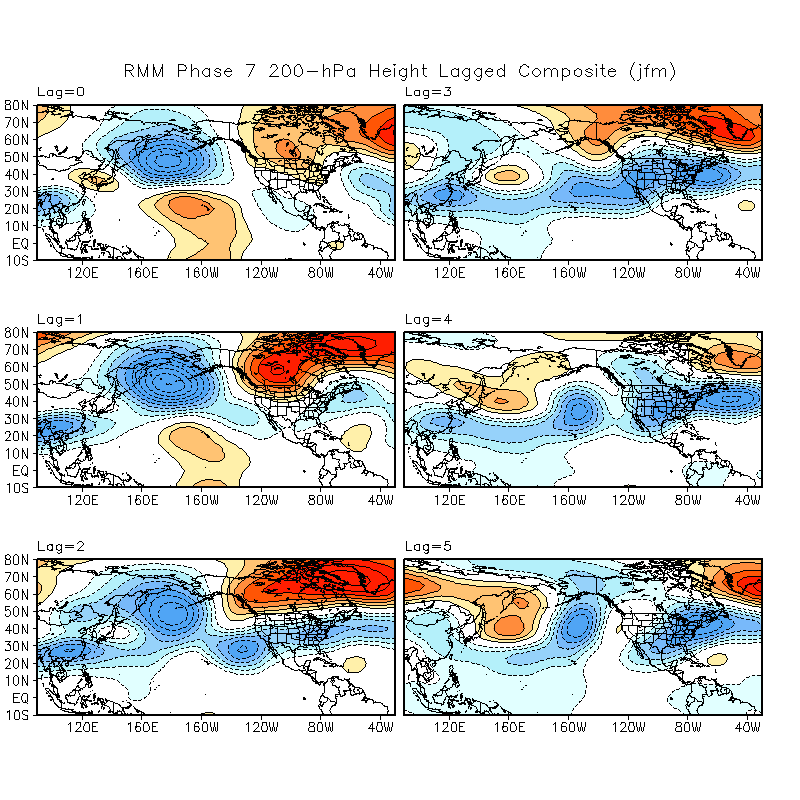
Beyond that weekend, there is MJO support for a week of weather to deal with!! See Below:
As you can see, there is a bias toward the return of storminess beginning about the middle of February for about 7 to 10 days. This is based upon the lag composites, using the GFS model; MJO RMM Phase Space, using late phase 6 into phase 7 for February.