Brought to you by Howard Sheckter
It’s Official…Biggest Winter already for April 1st of all time….Winter Storm Warning in effect now through Wednesday AM…..Cold Breezy Weekend expected…
Tuesday March 21, 2023
3-22-2023
The remains of the low pressure system that brought 18 inches of snow to the Main Lodge yesterday is moving out today. The storm total from last Sunday and Tuesday on Mammoth Mt was 34 inches. Both of these systems were all part of the same storm with the 1st part, the warm sector then the cold that hit yesterday. Mammoth Mt now reports a base at the Main Lodge of 664 inches with well over 800 inches on the upper mountain. (Historic)
The pattern through the weekend is a bit unsetteled with wind on Friday and some light snow showers at times. The next storm is slowing down a bit. It is expected Tuesday and Wednesday next week. Preliminary, it looks at least as stormy as yesterday’s system was for Mammoth. Will have more info on that storm later this week when it gets closer.
______________________________________________________________________________________________________________________________________________________________________________________________________________
3-21-2023
In checking the DWP data for Mammoth Pass this AM, the Pass has already surpassed the April 1st figures for all time with 90.3 inches of water and is 212% of normal for April 1st. During the big water year of 1983, 83.7 inches was on the Pass for 192% of normal. During the winter of 1969, 86.5 inches or (199%) of normal for that same date. It’s alleged, that during the winter of 1983, there was 90 inches at the Pass later that Spring. I am also working to find out what the extra precipitation amounts were during the winter of 1969, during April and May of that year. So, the new benchmark year for April 1st of any in the past is at 90.3 inches. More snowfall today will add to that April 1st benchmark as well as any future storms by April 1st.
Winter Storm Warnings are currently in effect through 5:00AM Wednesday. Expect 12 to 18 inches in town with “between” 2 feet and 3 feet along and near the Mammoth Crest according to WSFO Reno. This storm will stall this morning west of Monterey Bay and remain between Monterey Bay and the Bay area through Wednesday AM, before it shifts east Wednesday. There are a few colder storms over the weekend with light snow showers possible. It looks cold and at times blustery through the weekend. A low confidence outlook for next week shows the next storm on the 28th through much of the end of month. (Highly subject to change) QPF wise, it looks similar to this one. (2 to 3 feet) over the Crest) This mornings 12Z model run of the GFS has this system as the last of March.
ENSO: The “El Nino Southern Oscillation”
Its official; La Nina is dead! So what’s to come later this year from this change.
From the Climate Prediction Center;
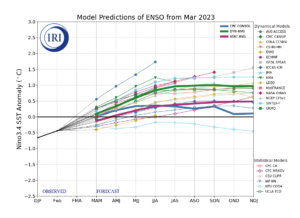
The most recent IRI plume favors ENSO-neutral to continue through the spring, with El Niño forming during summer 2023 and persisting through the fall. In contrast, the forecaster consensus favors ENSO-neutral through summer 2023, with elevated chances of El Niño developing afterwards. The smaller chances of El Niño relative to the model predictions are primarily because ENSO forecasts made during the spring are less accurate, and also the tropical Pacific atmosphere is still fairly consistent with a cool/La Niña-like state. However, it is possible that strong warming near South America may portend a more rapid evolution toward El Niño and will be closely monitored. In summary, La Niña has ended and ENSO-neutral conditions are expected to continue through the Northern Hemisphere spring and early summer 2023.
Of interest, see the Warm Kelvin Wave and its effect noted in the sub surface water temps. Look at the subsurface temp anomalies. Look at the effects of this surfacing warmth taking place off the Central America coast. See the latest forecast for ENSO Graph.
.


