Brought to you by Howard Sheckter
Archive for April, 2023

Chilly Unsettled period setting up for the Sierra next week……A real oppertunity to break 875 inch snowfall record on top of Mammoth Mt…..A Record that is little chatted about but Monumental….
Sunday April 30, 2023
After near record high temperatures this week, the warm upper high is currently shifting east….500Mb Heights are falling, cooling is occuring in the coastal cities of Northern CA and breezy weather has returned. Being that the Sun angle is now mid August like, surface convection will occur where ever possible, except over snowcover. The closed low developing off the coast will create massive upper divergence over Eastern California. QPF indicated by the CRFC shows up to 1.40 over Yosemite during mid week. Freezing levels in the 5K to 7K range. Precipitation will be mostly convective and TSRW will produce the best amounts. Would love to see current 875 inch snowfall record amount over top of Mammoth Mt broken with possible 900 inches in sight. You never know as it could happen. In the meantime, the heavy spring thaw weather will take a back seat as colder temps will slow down the melt. Highs some days mid week will cool to the low 40s with lows in the 20s. Best days and nights for precip will be Tuesday through Friday. Hope Mammoth Mt keeps tabs on the snowfall on the upper Mt to see if a 900 inch record occurs by weeks end.
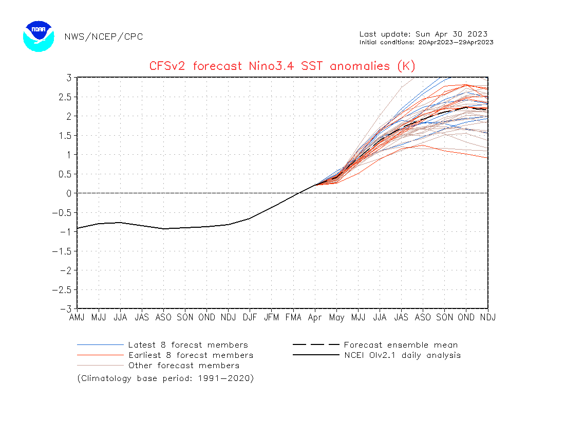
Next long range seasonal weather concern will be related to El Nino. El Ninos can be tricky. Big El Ninos are not always wet in California as they need to be “Full Basin” Will this be full basin warm El Nino? That will be up to the experts to varify. What’s a non full basin EL Nino” It’s called a Modoki event.
Milder days ahead this weekend through next week as the Sierra Thaw resumes… Next chance for unsettled weather seems to be in early May….
Wednesday April 19, 2023
4/23/2023
It was a beautiful weekend in the high country. High temperatures in town were in the low 50s and lows in the 30s. It was a bit breezy as expected. The thaw was in full swing with Mid August like Sun. In that the snowpack remains very deep and wide spread, surface enhanced convection was quite surpressed. It will take some strong upper divergence to create meaningfull precipatation here in the high country. This new week will begin much like this weekend. However, further height rises mid week into the weekend will provide for further warming. By mid week, highs could hit mid to upper 50s. Then low 60s possible by Thursday or Friday. 60s is really tough with the amount of snowcover we have, so time will tell. With the increase in run off later this week, there is bound to be some issues in the mid and lower elevation areas of Mono and Inyo Counties. Beyond next weekend, as touted, a change in the pattern is possible during the first week in May. A trough or closed low is expected to develop offshore. Upper divergence is expected to develop creating lots of unstable air. Again, with all the snowpack over the Sierra, that will to some degree, inhibit the type of storminess that benifits from surface CAPE. Nevertheless, the chance of showers, potential thunder and snowfall is still a possibility during the first week of May.
Next update the end of next week, hopefully….
The Dweeber…………….;-)
________________________________________________________________________________________________________________________________________________________________________________________
The Cold Trof that brought a inch of snow to Mammoth Mt yesterday along with strong gusty winds in the high country is continuing to shift east through Rockies. Strong height rises are occuring over the far Eastern Pacific and should shift inland this weekend. Its possible that this ridge and pattern could hold a good part of next week and even into the end of the month. However, there is a Great Basin/Rocky Mtn slider that will kick up more wind, Monday into Tuesday. Overall, nicer weather with high temperatures pushing well into the 50s at times in town will really increase the snow melt. There will be periods of afternoon winds, some days stronger than others. Lows at night will move up in the 30s over the weekend. At this point, the Dweebs do not likley see a major change in the pattern to unsettled, until the end of the Month or more likley early May. Inter seasonal maps show a chilly period returning with the possibility of some snowfall the first week of May, into possibly the 2nd week of May. This longer range is of course more speculative and subject to change.
Extensive Snowmelt is expected over the next 10 days……
Dr Howard and the Dweebs……………….:-)

After a chilly Thursday, a warmup is expected over the weekend before another spring trough visits our area early next week…..No major storms on the horizon………
Thursday April 13, 2023
4/14/2023
Global models this AM continuing to forecast periods of warming, cooling, periods of wind and periods of snow showers for Mono County the next few weeks. No major snow producing storms are in the forecast for Mono County.
Thursday’s weather system is now in the Rockies and high pressure aloft is building in today into Saturday. A warming trend is under way today with highs in the 40s vs yesterday’s upper 30s. Highs will jump into the low 50s on Saturday and a resumption of the great thaw of 2023 will return this weekend. However, being that this is April, there will be plenty of cool spells that will alternate with our warm spells. A pattern of warmth on weekends followed by cooler weather during the week seems to be the way the weather will trend. Winds will be the “lightest” tomorrow Saturday for Owens Valley while highs will return to the low 70s. On Sunday, both Mono County and Inyo County will experience more wind. However, high temperatures will warm further as well. The wind on Sunday is the harbinger of more trofing next week that will bring a good 15 degrees of cooling to our high county by the following Tuesday. Highs in Mammoth will cool to the mid-30s with teens returning by Wednesday AM. There may be snow showers, especially on Tuesday AM and again Thursday. This pattern is highlighted by the forecast of the upper jet axis remaining mostly north of Mammoth. This ensures that most of the precip will be Tahoe Northward next week. The Northwest Jet is a pain in the @##. Upper convergence favoring the Central Sierra often makes for pesky winds, and these are likely to be with us, on and off, Monday through Thursday next week. At this time, the remains of this pattern may push through by next Friday, leaving a calm warmer weekend for the 22nd.
Don’t forget about the Lyrid Meteor Shower; (late evening to dawn on the nights of April 21-22 and 22-23)
Dr Howard and the Dweebs…………………..:-)
___________________________________________________________________________________________________________________________________________________________________________________________________
4/13/23
Its Springtime in the high country and Spring Trofs will continue to progress through the west coast, until Summer Arrives. Wind….Showers and cooling will alternate with warm periods as well. Although a moderate MJO is getting ready to pass through the infamous phase 7/8 into phase 8, now that it’s Mid-April, the most significant influences will most likely be up into the Pacific NW. This also includes any significant Atmospheric River action. This is not to say we could not get a meaningfull snowstorm before the end of April and even May. However, it is unlikely that we will experience anything like this past winter.
The MJO of late February into March was almost off the charts in the RMM Phase 8 sector. (see graphics) This was instrumental to the many AR’s that affected CA this late Winter. It is a known fact to many inter-seasonal forecasters, that the Madden Julian Oscillation, can modulate the Westerlies in the right location and extend the East Asian Jet Stream well into the west coast and bring very wet weather to wherever it hits. In this case, it has been California. However, the media’s tout of 32 or 33 ARs this wet season is over blown.
Scripps Institution of Oceanography at US San Diego’s intent, I believe, was not to create an over blown character to describe this winter’s series of AR’s. As an example, the AR 1 (weak) and AR 2 (Moderate) are not often Hugh storm producers for the Sierra. Also, one must remember, that you can get an AR of significance, however, without any dynamic lift, you do not get much more than light precipitation at best. It’s like the Monsoon moisture argument. You can get a strong monsoon surge of moisture and get little rainfall without dynamic lift. It is very important to remember that for the Sierra, the AR needs to be at least Category 3 or stronger for a major impact, as well as extend into the Sierra itself. Some of these smaller ARs barely made it to the coast this Spring, let alone through the Sierra. So, 32 ARs? Hype Hype!!! Scripps only puts out a notification of an AR when a Cat 3 or greater AR is expected. See and book mark this link for more information on the Atmospheric River. https://cw3e.ucsd.edu/iwv-and-ivt-forecasts/