Brought to you by Howard Sheckter
Dry Weather Returns To The High Country with Seasonal Temps…..Light Zephyr Breezes To Rule The Late Afternoons And Early Evening Hours…..
Monday August 1, 2011
Tuesday Update:
Dryer air moved in last night as evidenced by the Wave Loop and a weak summertime trof is approaching the West Coast. In that the long wave trof is still anchored well to the west of us and the western hemispheric teleconnections previously discussed below are still in place, see no reason not to believe that Monsoon III is nowhere in sight….that is that, if there will be a Monsoon III? Confidence is very high in this long range outlook because of the tight clustering of both ec and gfs global models.
Short term forecast: Dew points are still pretty high today Tuesday as the forest is still drying out from three days of rain. .01 fell in the http://mammothweather.com bucket, just enough to tip the handle and give us at least .01 for the new month of August. Today’s showers if there are any will be mainly focused along the Mono/Mineral counties convergence zone. That is where the winds coming up the Owens Valley clash with the south westerlies coming over the Sierra. This zone will be mainly east of Highway 395. By Wednesday, the thunderstorm threat should be over in its entirety for Mono County.
The new pattern is sensibly the old pattern, or a return of the old pattern from most of July. Highs in Mammoth will average out in the mid to upper 70s and lows in the 40s…..late afternoon breezes will be mostly in the 10 to 20 mph range with some early evening gusts to 30mph out of the SW.
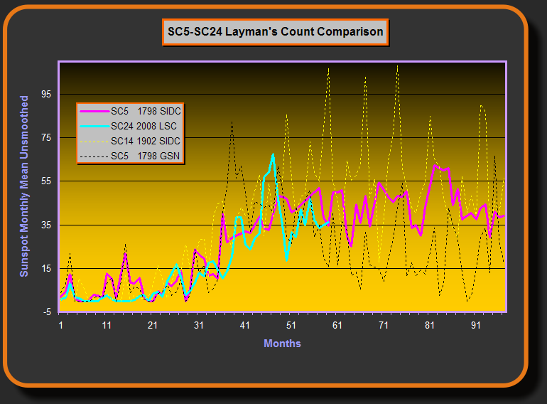
Solar Update:
Although solar activity has picked up the past few days…..For the past four months according to Geoff Sharp,a solar scientist, the F10.7 flux has been moving in the opposite trend to all sunspot counts. SC24 is still on track, undercutting SC5. SC 5 was associated with the Dalton Minimum back in the very late 1700s and into the early 1800s where the world was a cooler planet and winters were harsher. See: http://www.landscheidt.info/images/sc5_sc24.png and for his NH winter forecast see: http://www.landscheidt.info/?q=node/224
FROM MONDAY:
Monsoon II proved out to initiate the best thunderstorm “outbreak” of this year with many Mt. areas getting well over a half inch of rain over the weekend. By Tuesday/Wednesday, expect a return to the usual dry southwest flow that will last possibly two weeks.
Looking at the analog composites from CPC for both 6 to 10 day and 8 to 14 day means, it is apparent that above normal upper heights will remain over the Davis straits near Greenland and over the Aleutians as well. This will keep lower then normal heights in place centered at about 135 to 140 West, and so a persistence of SW flow should keep monsoon moisture well to our east. Heights will remain highest over the four corners states eastward to Texas and so monsoon moisture is likely to be channeled mainly into AZ, Eastern NV, Utah. There may be some seasonal wind excursions into extreme SE Ca deserts.
The Central Sierra should remain Monsoon Free with only a slight chance convergence type storms over the next two weeks. They would be isolated at best and mostly east of Mammoth. In that our air mass will be dry by Wednesday and that at the same time, heights still pretty high…..temps will average near normal. That would be mid to upper 70s through the period and mid to upper 90s in the Owens Valley.
Forecast is for Scattered Thunderstorms today Monday and isolated storms Tuesday. highs in the 70s… lows 40s…
————————————————-
Reference Glossary of Weather Terms
Disclaimer: I have been a hobbyist meteorologist for over 30 years here in the Mammoth area and I do this for my personal enjoyment. The National Weather Service saves lives every day . . . I do not. When making important planning decisions please use information provided by the National Weather Service as they are the most knowledgeable and accurate information source available today.


