Brought to you by Howard Sheckter
Short Term and 7 day Forecast Continue Dry…..However Some Interesting Possibilities Developing With MJO Over The Next 7 to 15 Days
Saturday January 28, 2012
MJO…that elusive little inter-seasonal phenomena may play an important role in California weather, Beginning toward the end of the 1st week of February then develop stronger during the 2nd week of February.
See: http://www.cpc.ncep.noaa.gov/products/precip/CWlink/MJO/CLIVAR/clivar_wh.shtml
What is significant is that it projects strongly into the MJO “Phase Space 7” (EL NINO LIKE). The NCEP’s NCPE (Operational), NCPB, (Ensemble) and NCPO Bias corrected Ensemble are singing the same tune as well as some of the EURO Models. The Climate Prediction Center / NCEP update will be out early next week and should shed some light on the possibilities then…. Additionally…..the Dweebs expect Atmospheric angular momentum to soar for the first time this winter!! Will post the Global Wind Chart “GWO”…….. later next week
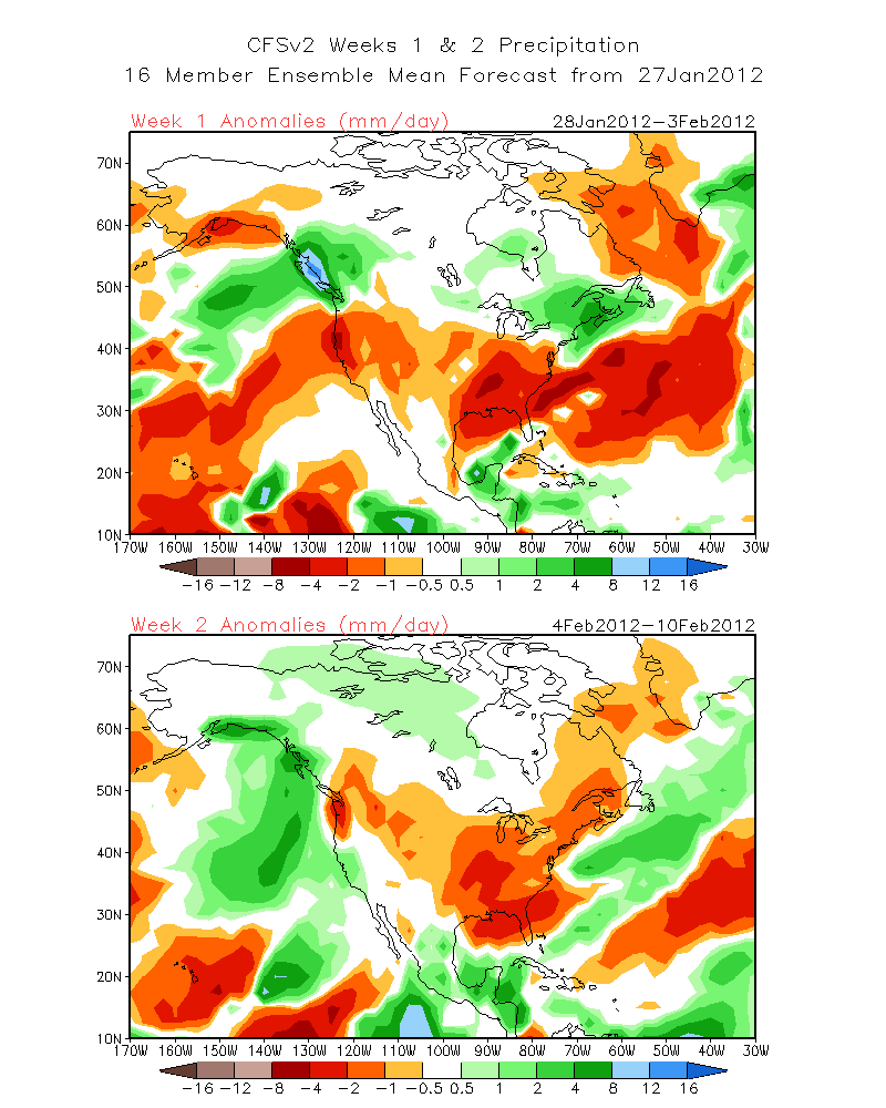
Additionally, the climate models are wetter for California (precip) with an under cutting 500mb signature with higher heights over the pacific NW Week 2. See: http://www.cpc.ncep.noaa.gov/products/people/sweaver/cfs_fcst/images1/wk1.wk2_20120127.NA.gif
Looking at the MJO Precip composites for the Month of February, there is a strong signal with a strong incursion of MJO into Phase Space 7 and above normal precipitation in Central California. It is several deviations above normal. Although it is forecasted to move into Phase Space 7 about the 9th of February, The Climate models bring wet weather earlier to the state. Could they be too fast? Phase space 7 is the pseudo El Nino State in which tropical convection moves east of the dateline. This would spin up the subtropical jet strengthen it and provide the means for strong undercutting of the highly amplified ridge that is expected to form next weekend. This is exciting stuff……:-) More Later>>>>>>>>
Here is the argumant against the idea of a strong enough jet to provide significant undercutting….
SSTA’s are -1.1C in the Nino 4 region. Although La Nina has been weakening in the Nino 1 and 2 region…region 3-4 is still -1.1C. This will work against any “strong tropical convection” trying to make it east of the dateline. Lets hope the Tropics will boil with convection from the dateline east as the inter-seasonal wave develops…strengthens in phase 6 then shifts east as it goes through phase 7. The AO has turned decisively negative.
Dr Howard and the Dweebs……………………………..:-)
————————————————-
Reference Glossary of Weather Terms
Disclaimer: I have been a hobbyist meteorologist for over 30 years here in the Mammoth area and I do this for my personal enjoyment. The National Weather Service saves lives every day . . . I do not. When making important planning decisions please use information provided by the National Weather Service as they are the most knowledgeable and accurate information source available today.


