Brought to you by Howard Sheckter
Mammoth Mt Picks up 12 inches Past 24 hours….Snowshowers expected throughout the day……Next System This Weekend…..
Wednesday February 15, 2012
Nice little storm with a 4+ inch per hour burst at the main lodge between 6:00am and 7:00am. So we did a little better then expected….
The upper level system will head due south today…away from Mammoth, with a chilly air mass in its wake. Gusty winds will continue throughout the day. Expect highs in the mid 20s at the Village and teens up on Mammoth Mtn today.
The next weather system to effect our area will be Saturday through Monday. The current runs do not form a close upper low at this time with it. So, in will probably be a faster mover, less dynamic and bring less amounts of snowfall. Best guess at this time 2 to 4 inches….Saturday through Monday AM
It’s always nice to get snowfall when the PNA index is positive. I guess its a blessing with the mean ridge position is just far enough west for systems to drop over our heads, for some light to moderate snowfall. The snowfall that fell is the light powdery kind with ratio’s about 15:1
Well its the Middle of February, the Air-Sea coupled models are still touting a wet beginning to March, what say the MJO?
Of note…
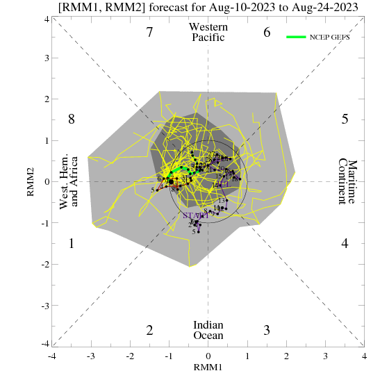
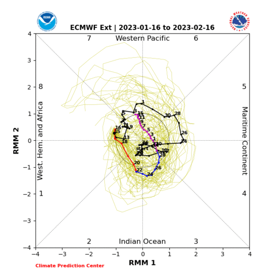
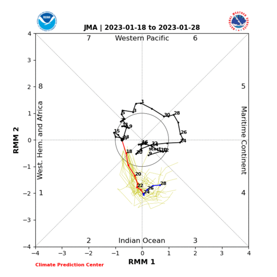
All three of these MJO Phase Spaces that extrapolates the MJO beyond the data point are showing either a bounce into Phase Space 2 or a moderate to strong incursion as it travels eastward through phases 1…2…3…and possibly 4. Again like was explained last week….. The MJO moving into Phase Space 2 causes the upper jet across the pacific to contract (retrogression) which results in a FLIP in the PNA index to Negitive. IE. Trofing over the Eastern Pacific and storminess south down the west coast. The PNA teleconnection is currently in the positive phase. For further discussion please check previous discussions….over the past 7 to 10 days.
Here are the 3 phase spaces that the Dweebs watch:
NCPE: (From The NCEP Ensemble) (American)
http://www.cpc.ncep.noaa.gov/products/precip/CWlink/MJO/CLIVAR/NCPE_phase_21m_small.gif
EMON: (From The EC Ensemble) (European)
http://www.cpc.ncep.noaa.gov/products/precip/CWlink/MJO/CLIVAR/EMON_phase_51m_small.gif
JMAN Ensemble: Japan Met Agency
http://www.cpc.ncep.noaa.gov/products/precip/CWlink/MJO/CLIVAR/JMAN_phase_51m_full.gif
Of Note:
The latest 12z GFS is showing retrogression of the HT 500mb height anomaly during week 2. So the flip may occur during the last week of February with serious storminess returning to the high country the last week of this month.
Comment: The Air-Sea coupled model has predicted this for first week of March.
So today’s 12Z, 2-15-12 GFS run may be too fast?
Dr Howard and the Dweebs…………………………………..:-)
————————————————-
Reference Glossary of Weather Terms
Disclaimer: I have been a hobbyist meteorologist for over 30 years here in the Mammoth area and I do this for my personal enjoyment. The National Weather Service saves lives every day . . . I do not. When making important planning decisions please use information provided by the National Weather Service as they are the most knowledgeable and accurate information source available today.


