Brought to you by Howard Sheckter
Last Full Week of Spring To Be a Warm One with Only Summer Like Convection Expected Thursday and Friday……Then Warmer Again Over The Weekend
Monday June 11, 2012
The Jury is in from both ECMWF and GFS Ensembles and deterministic runs today showing much less amplification over the Northeast Pacific and a general flatter flow through the Pacific Northwest. So we will not get that cold little bugger that was highlighted B-4 last weekend for next weekend or “Springs Last Weekend”. Instead expect warmer then normal temps!
This weeks highlights is less afternoon wind early in this week…then a bit stronger zephyr Wednesday and Thursday followed by the common Mono convergence zone setting up for a few days as the thermal trof shifts east allowing winds from the south to move up from the Owens Valley. They will then converge with West Winds off the Sierra forming “isolated” showers and Thunder showers Thursday and Friday. These will be of the garden variety….often forming on the back side of Crowley Lake….Sherwin Summit……the Whites and over the Bodie Hills……Nice!
Although the GFS numerical guidance is showing temperatures above freezing at the surface above KMMH the next 384 hours…the Dweebs are not totally convinced that we are out of the woods on another freeze, as the Eastern Pacific Ridge is set up west of 140w and south of the Aleutians. All it would take is a strong storm moving across the north pacific to Amp the pattern and pull down some chilly air. SSTA’s are still quite a bit below normal south down the west coast to about Pt Conception which supports trofing off the west coast from an SSTA point of view.
Based upon the Guidance there is some support of a freeze between the 18th and the last week of June.
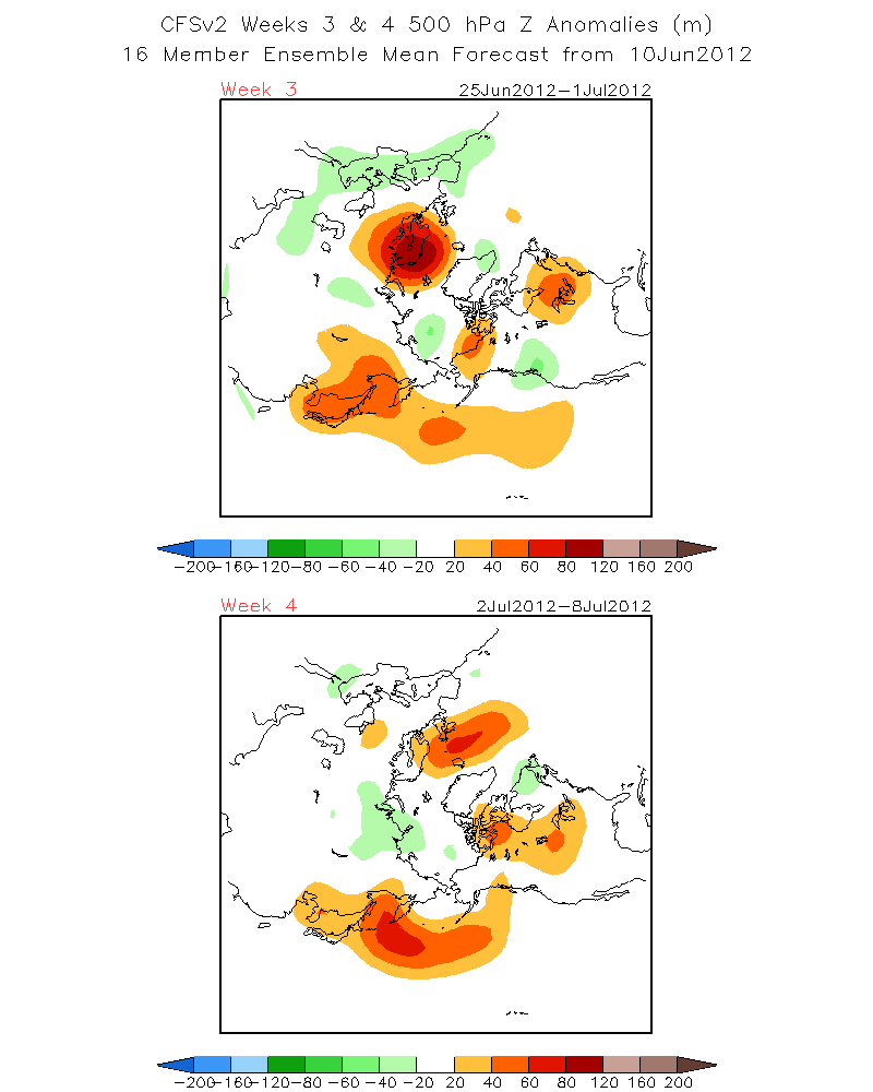
See: This CFSV2 weeks 3 and 4 500 hpa Z anomalies (m)
http://www.cpc.ncep.noaa.gov/products/people/sweaver/cfs_fcst/images1/wk3.wk4_20120610.z500.gif
8 to 14 day from Sunday:
http://www.cpc.ncep.noaa.gov/products/predictions/814day/index.php
Thereafter climatically it is all over freeze wise after the first few days of July on…..
In the meantime temps at resort levels should remain above freezing the next 6 to 10 days.
ENSO…..
ENSO conditions are currently Neutral according to the CPC
The odds of any El Nino this year is forecasted to be more Weak to slightly Moderate at best…..developing this Summer or Fall. Even so the odds are only 50-50 today.
The CPC graph shows Weak El Nino conditions expected to develop later this summer to peak this fall according to the CFS V.2 Ensemble Mean in Sept-Oct-Nov then begin to weaken the end of the year then cool toward normal or fall below the .05c criteria during the Winter-Spring of 2013. Neither the CFS V.1 or V.2 Ensemble Means predicts ENSO to cross the Barrier from Weak to Moderate.
Weather:
Weak/Mod El Nino’s usually favor the classic split flow pattern off the Ca coast where the upper jet splits bringing precip to the coastal section of Ca, south to Southern Ca. If Enso does reach warm criteria…the key to our weather will actually be how the split and where the split develops. Split flow patterns usually bring wet weather to the coastal sections of California IE the Bay Area then south to LA. The big question will be where the track of the upper lows go after the split. Will they track inland far enough north to get Mammoth or will we have lots of west side events waiting for the wrap around! Additionally it might be noted that the MJO is more active further east during Weak La Ninas to Weak El Ninos. Will we smell the pineapples next winter? In addition….Some weak El Nino winters coming off of La Nina Winters have in the past, given us some pretty cold Arctic outbreaks in the far west. Will we have a December to remember like the 19th of December 1990? For you longer term locals, I am referring to the Night of lights December 1990 when it was -12 below at the Main Lodge for the night of lights…..
The Dweeber…………………………..:-)
————————————————-
Reference Glossary of Weather Terms
Disclaimer: I have been a hobbyist meteorologist for over 30 years here in the Mammoth area and I do this for my personal enjoyment. The National Weather Service saves lives every day . . . I do not. When making important planning decisions please use information provided by the National Weather Service as they are the most knowledgeable and accurate information source available today.


