Brought to you by Howard Sheckter
One More Warm Day then Cold Blustery Storm to move into the Sierra Thursday PM…..
Monday November 5, 2012
1:45pm Nov 6th
ECMWF has a total of .8 over the crest through Sunday AM. So we do get up slope and the ratios are probably 13:1 to 15:1 Saturday/NGT.
I guess the best part of all this documenting is that we will all find out at the end of this week, how the models handled the QPF for this pertictualar weather type and trof best. If we believe the ECMWF qpf, it is getting pretty close to 10 to 12 inches at the higher ratios over the crest considering the up-slope Saturday by Sunday AM. Too bad we don’t have a 5 foot base, or we could call it a nice shot of “Platinum Powder”.
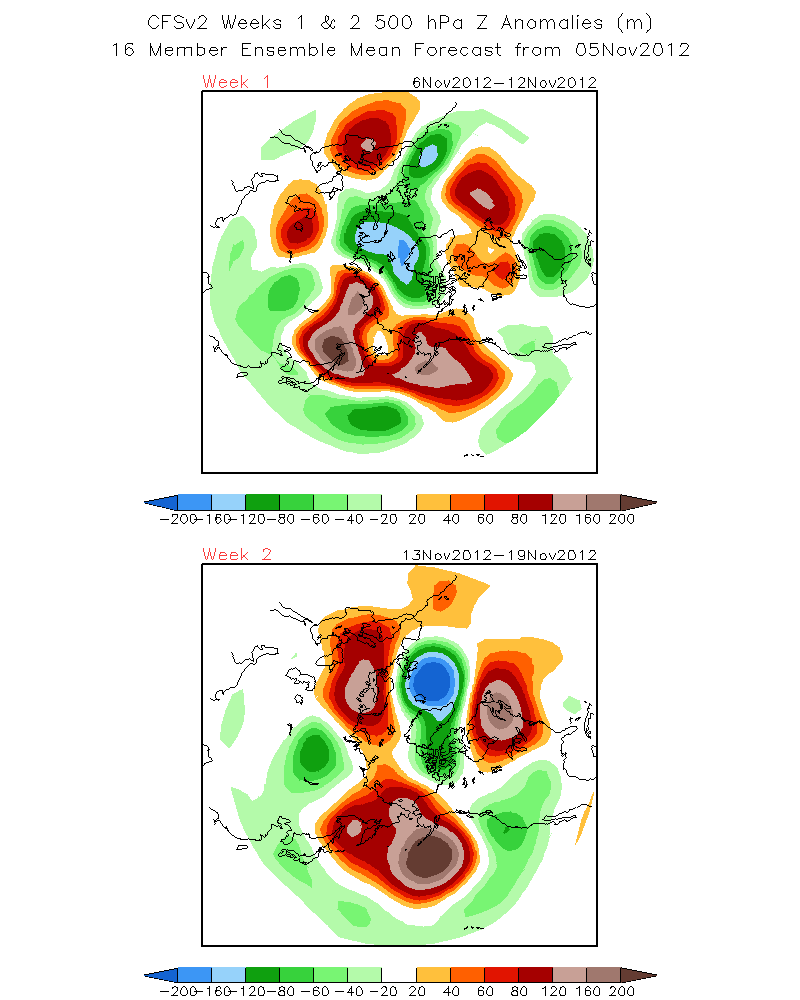
I mentioned the Climate Forecast System earlier today. That it is showing an 500hPa Z,, negitive height anomaly (m) Nov 13th through the 19th Nov (week 2)……centered 20 or 30 miles off the Northern Ca Coast.
SEE: http://www.cpc.ncep.noaa.gov/products/people/sweaver/cfs_fcst/images1/wk1.wk2_20121105.z500.gif
The upstream ridge is positive tilt which may cause the upper flow to split as it comes southeast. Some of the models are trending in that direction. That would favor a system that spins up further south then the graphics show above. This would favor the Southern California mountains in getting hammered with heavy snow with generally lighter amounts for the Eastern Slopes of the Sierra around the middle of next week. (14th) As we all have seen, the Dweeb like to banter a lot when its a week plus away as there are always lots of possibilities…..However when you are 72 hours from showtime, the models are usually in sync.
The storm for the weekend looks like a 5 to 10 inch system between 8,000 and 11,000 feet over a 3 to 4 day period.
________________________________________________________________________________________________________________________________
Needless to say, after looking as all the guidance this Am, the QPF ranges from skimpy to light with possibly borderline Moderate over the Mammoth Crest. CNRFC gives Yosemite about 1/4 inches of QPF while the new 12z GFS and WRF paint somewhere between 1/4 and 1/2 an inch. The EC is the wettest through Saturday with close to .75 (It may be expecting a few inches of (up-slope?)
Keep in mind that temps between 15F and 20F can deliver snow to water ratios as high as 15:1. So a lot depends upon when the moisture comes in; IE. before the front in the warmer air, with the front or after the front in the colder air. Looking at the Tuesday 12Z WRF, at 500mb and 700mb, there is good westerly flow aloft between 10,000ft and 18000ft on Thursday/NGT…..However at 700mb, only about 40%-50% RH is indicated. The best 700hr moisture of 50% to 70% comes in behind the front in the NW flow at 10,000ft early Friday. “Not good for Orographics!”
This appears to be a system that does not get all the players on the line in time for the snap! So as of today Tuesday, light amounts in town would be favored along with strong winds and very cold temps arriving into the weekend. Saturdays highs will be in the mid 20s with night time lows in the single digits!
Note:
The 12z GFS has the Rt Rear entry region effects our area late Thursday afternoon and so decent UVM should occur at that time with the upper jet working its way SE. again, much of the precip is expected to fall after the front so we will be able to take advantage of the higher ratios.
Dweebs Criteria for light amounts for this area is 1 to 6 inches. Moderate 6 to 18 inches.
Longer Range:
The CFS is showing a pretty strong negative height anomaly off the California Coast between the 13th and the 19th of November!
The Dweebs will take another look at it either tonight or Wednesday AM…………………………..:-)
————————————————-
Reference Glossary of Weather Terms
Disclaimer: I have been a hobbyist meteorologist for over 30 years here in the Mammoth area and I do this for my personal enjoyment. The National Weather Service saves lives every day . . . I do not. When making important planning decisions please use information provided by the National Weather Service as they are the most knowledgeable and accurate information source available today.


