Brought to you by Howard Sheckter
Winter’s Severe Cold Snap is Now Broken….Only the Valleys of Mono County Remaining Cold……MJO on the Move!!!
Tuesday January 15, 2013
Quick Update Wednesday AM:
Quasi stationary upper high is located about 150 to 200 Miles west of SFO. At 700MB (10,000ft), it shifts toward Northern Ca tonight as the winds then become more Northeasterly. By Thursday PM, 700MB winds are easterly over the Lip as the 700mb high is centered over Northern Ca. By Saturday and into Sunday the 700MB high is located over NW Nevada and the upper flow at 10,000 will be southeasterly. So winds in town will be calm to light through the weekend and winds over the Mammoth Mtn Summit will be moderate today and then lighter tomorrow then light to moderate through the weekend.
No new snowfall is expected through next Wednesday the 23rd.
Longer Range has the possibility of precipitation between the 26th and the 31st
The high temperature forecast for the Town of Mammoth is 45 to 50 through the weekend
Night time lows will range from 15 to 25 degrees with the coldest temps at lower elevations.
Strong inversions will persist well into next week. This mornings low temperatures ranged from, -9F at Bridgeport to 14.5F at the Mammoth Ranger Station to 21F at the Village at Mammoth. The over night low at the Main Lodge was 25F Degrees and the same over night low of 25F occurred at the Mammoth Mtn Summit.
The high temperature yesterday in Mammoth was 45 degrees…..
Again…..Moderate winds this morning over the top of Mammoth Mtn were blowing about 55MPH out of the North. They will diminish a bit Thursday as they shift and become easterly at the same time. By Friday, the 700MB high is forcasted to be more over NN Eastern Ca and the winds become ES-Easterly and pick up slightly.
Overall beautiful weather for the next week!!!!
____________________________________________________________________________________________________________________________________________________________________
Note: Gusty NE winds of 50MPH are blowing over the top (lip) of Mammoth MTN this AM. Wind speeds are much less over the lower slopes.
Wow! What a cold snap! The last three to four weeks will be memorable. Temps ran -20 to -30F last weekend in many valleys areas along the highway 395 corridor. Mammoth’s temps bottomed out at -5F at the village yesterday AM while at the corner of Main Street and Old Mammoth Dr -9F. This morning, waht a difference. Temperatures were some 20 to 25 degrees warmer, with a low of 15F here at http://mammothweather.com at the 8200 foot level.
The freezing level over Yosemite that was about 1000 feet yesterday, rose to 8300 feet this morning and will jump to 12,500 by 4:00pm today! Highs will be in the low to mid 40s today at 9800 feet while the valleys under the inversion will be in the 20s at best. By tomorrow, the inversion tightens up further and the valleys will get even colder while the upper elevations continue to enjoy 40s for highs. Lows at night will be mostly in the 20s, but could be colder in the lower elevations of town. If the inversion gets squashes to 7500 to 7700 feet. The Village at Mammoth could be near freezing for a low while at the Trails Subdivision, it could be in the upper teens to low 20s.
Ok, enough about inversions. Only one more issue to mention. Its been below freezing including in many garages in Mammoth for days. Once temperatures warm up, frozen pipes are going to thaw and water problems may become an issue for many around town. If your water is left on at your vacation home and you live out of the area, make sure to check with your absentee home caretaker to make sure you do not have broken pipes. Many frozen pipe problems are not realized until the weather warms up outside. Then, if left days or longer, you can have some real interesting things begin to grow in the walls! 😉
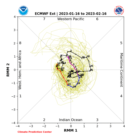
MJO:
During the first week of January, a rapidly intensifying MJO developed in late phase 4, while the GWO showed relatively low AAM. (Atmospheric Angular Momentum) AAM is on the increase and the MJO is shifting east. The MJO is now in the early stages of Phase 7 of the MJO phase space. There has also been an important Kelvin Wave associated with it. http://www.esrl.noaa.gov/psd/map/images/gcm/gwo_40d.gif
The global models and ensembles including the EC, GFS and Canadian have been in the past several days, containing the MJO in its current location. See: The EC ensemble prediction model: http://www.cpc.ncep.noaa.gov/products/precip/CWlink/MJO/CLIVAR/EMON_phase_51m_full.gif However, the statistical model See: http://cawcr.gov.au/staff/mwheeler/maproom/RMM/fcsts/pd.MW05.Last.gif Keeps the MJO moving right on through Phase 7 & 8. At the same time, AAM is currently showing an increase.
Comment from the CPC: Extratropical impacts of the MJO are likely to remain important over the next couple of weeks as the diabatic heating serves as source for downstream Rossby wave propagation. Should the MJO propagate through phase 6 and into phase 7 as predicted, it could force a jet extension into the Pacific with important downstream consequences for North American hydroclimate through the end of the month.
Dweebs Comment: The MJO shifting through Phase 7 and into Phase 8 moves the tropical forcing beyond the dateline toward the Hawaiian islands. This process often times serves to extend the Asian upper jet east. The upper jet eventually splits, during the process of retrogression of the blocking high, that is currently setting up over the far west. The northern branch of the jet on the eastern flank of the upper high becomes confluent with the southern branch which undercuts the retrograding upper high. The is the scenario for the classic “pineapple connection” which is more likely to effect the pacific northwest 1st, then over time shift south to Northern Ca then sometimes Central Ca.
This is what the Dweebs will be most focused upon over the next week. “This is not a forecast”, but is a serious consideration. The other features worth noting will be the other teleconnections which will play a part to either support or suppress such possibilities.
One thing is certain, we here in the high country are done with frigid weather for a long time!!!
Dr Howard and the Dweebs…………………………..:-)


