Brought to you by Howard Sheckter
Fair and Warmer this week….Lighter breezes…..Pattern Change Next Week to Colder then Showery Weather…Otherwise Dry Weather Through Sunday….
Tuesday February 12, 2013
The weather will remain fair through Sunday with a gradual warming trend. High temps will finally move above freezing over Mammoth with temps in the upper 30 today and 40s Wednesday through Thursday. We may expect highs in the 50s Friday and Saturday. Lows at night in the teens and twenties. Winds in town will be light out of the NE.
Pattern Change: The Dweebs had a look at lots of longer range guidance this AM. Tropical forcing is just now getting ready to move off the African Continent and will slowly move east over the Indian Ocean the next 1 to 2 weeks. It is moving much slower then the Dynamic Model forecasts…..possibly due to Kelvin wave activity? Today it is still over Eastern Africa just about ready to move over the Indian Ocean. Once it gets well over the Indian Ocean, the Asian Jet should contract allowing retrogression of the long wave trof over the east…back to the west. This is about a two week process. In the beginning…This will bring a return of cold, windy, showery weather to the west and dynamic weather to the central plains as early as Tuesday/ Wednesday next week. After all were getting close to March and severe weather is only weeks away for the southern Great Plains.
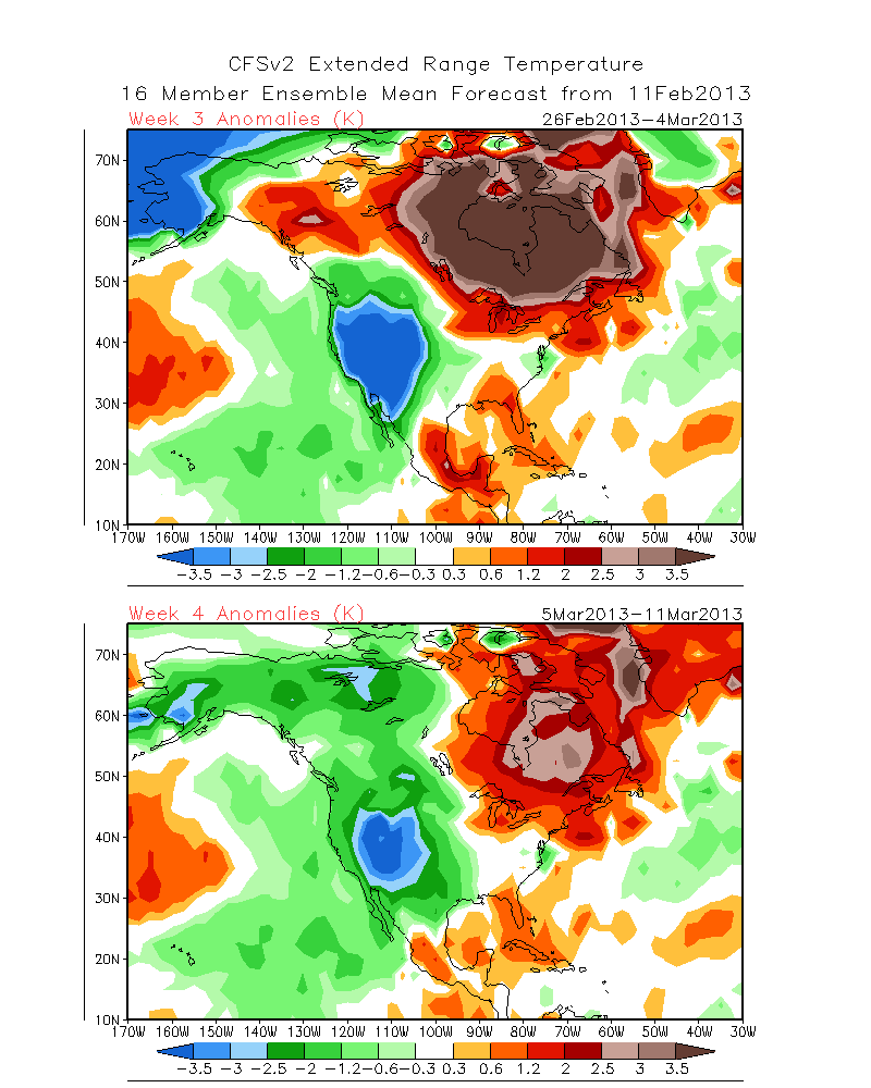
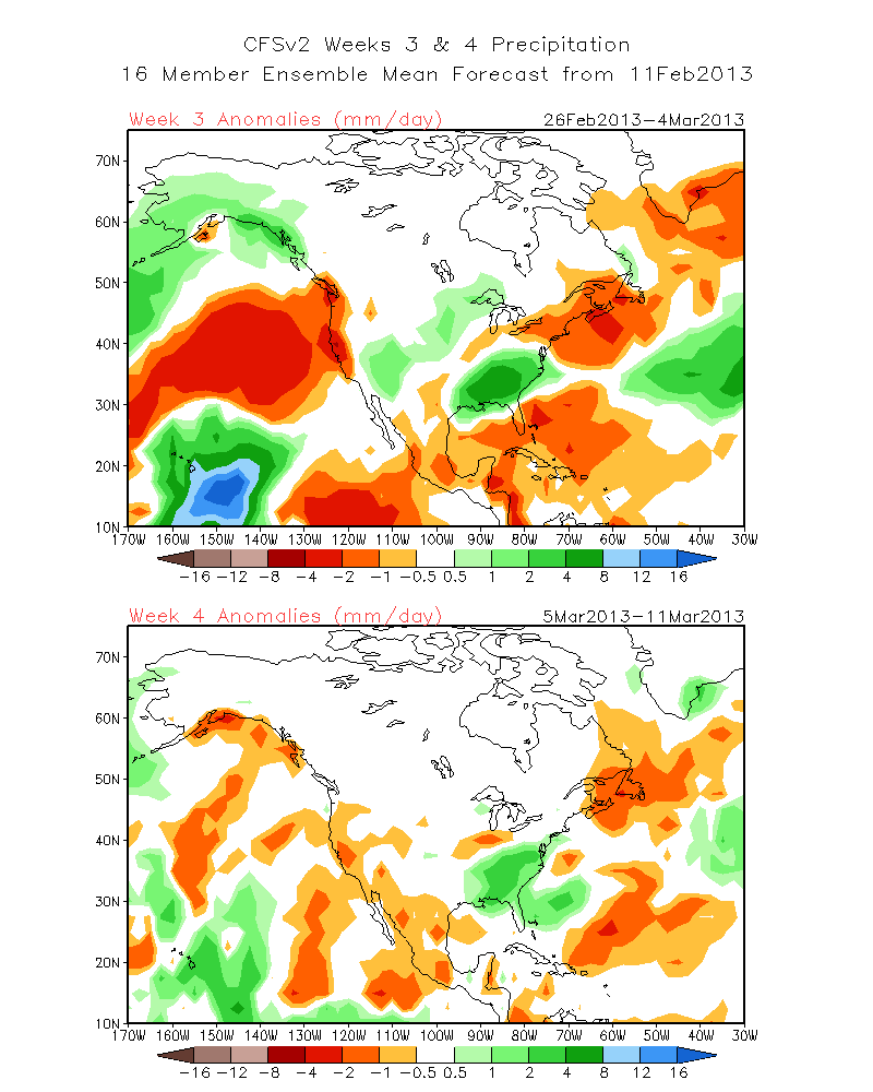
The forecasts from the CFS is showing a very cold period for the far west around the 1st of March.
See: http://www.cpc.ncep.noaa.gov/products/people/sweaver/cfs_fcst/images1/wk3.wk4_20130211.NAsfcT.gif For Temps
See: http://www.cpc.ncep.noaa.gov/products/people/sweaver/cfs_fcst/images1/wk3.wk4_20130211.NA.gif For Precip
While it is not high on precipitation…it is very cold. Additionally, HPa 500 mean heights are low over the inter mountain west….suggesting that we over California will be on the back side of the long wave, not on the wet front side. This is reminiscent of a cold showery pattern for the western Great Basin and Sierra with cold showery type storms. The Dweebs feel we will know a lot more of the evolution of the pattern to come by the end of this week. So yes…the MJO will cause retrogression……but will it be too weak to pull the long wave negative mean height anomaly off shore? The Dweebs would like to see its axis about 130 west! Is it possible? Sure! It would not be the 1st time that the CFS was wrong! 😉
Tuesday PM Update from the CPC:
The MJO favors, on average, a mean trough across the western U.S. near or just after mid-February suggesting elevated chances for below normal temperatures across parts of the western U.S.. As we approach the end of February into early March, the MJO would favor a retrogression of the ridge trough pattern across the mid-latitude Pacific – North America domain and would elevate odds for troughing near or along the west coast and a tendency toward a mean ridge across the eastern U.S., favoring elevated chances for above-normal temperatures for
portions of the east central U.S. and a more active weather pattern for the western U.S. with enhanced chances for above-median precipitation in areas that have seen on average below-median rainfall the last several weeks. The latter is currently at odds with Week-3 extended range model guidance. This is in relation to the links above…..
Next: Check out the Latest PNA Teleconnection forecast from the ESRL Ensembles:
http://www.esrl.noaa.gov/psd/forecasts/teleconn/images/compare.pn.png
So enjoy the very nice weeks weather at hand and get ready for the cold, windy and snow showery weather next week…..
This week will be the time to be watching the week 2 fantasy charts and EC. Lots of excitement ahead to follow!!!
The Dweeber…………………………….:-)


