Brought to you by Howard Sheckter
Temperatures to remain normal to above the next week with chances of some summer type rainfall increasing Sunday then into Tuesday……CFS Today has El Nino Beat Picking Up Tempo for California Winter of 2014……
Friday August 16, 2013
Sunday Am Update:
Offshore weak trof is now a cut-off low. It was located a little SW of Monterrey Bay at Sunrise. It will spin up a bit drift slightly south over the next 36 hours and so its effect upon the Sierra Tomorrow over today will be greater. PWAT is not impressive today. About .65 over Mammoth but will increase Monday into Tuesday. It is estimated by Tuesday, up to 1.00 of PWAT is possible, as both Air mass Modification and a deeper SE flow runs up the spine of NV/CA to add to the mix. Yesterday and again today antecedent conditions were/are very warm. That will add to the process as temperatures reached 82 yesterday…..100 in Bishop. So we have plenty of heat from below. Divergence aloft is increasing along with terrain driven convergence…and so the moistening process will be strong. The tempo should really increase tomorrow as the position of the Upper Low will be more favorable to Mammoth Lakes than today.
Today’s storms will not be as wet as Mondays and Tuesdays or as numerous. Looking at the SPC, the only real area of 300mb divergence today is over the Southern Owens Valley at this time. However at 10:23 Am Sunday, there was a small 850mb-250mb Divergence/Convergence couplet showing up on the SPC over Southern Mono County. Again expect some isolated TSRWS this afternoon including Mammoth Lakes. But the wetter storms will certainly be Monday/Night!
The only other thing worth mentioning today Sunday is the formation of tropical storm IVO west of Acapulco and yet another depression later in the month. We are getting into that time Climo wise where a tropical storm could pump some moisture into LA…then up into the Sierra there after. Some of the forecast models already track IVO toward Cabo San Lucas, bringing very unsettled weather by or just before next weekend. Moisture from one of those systems may bring some rain to Southern Ca. if the midlevel and upper flow are favorable.
From Friday:
The Dweebs Acknowledge that outside of the few week’s of Smoke this Summer, it has been one of the best Summers weather-wise in memory. Highs have ranged from just a few periods of low 70s during a few cool spells to the low 90s very early in the Summer. We have had a few spells of rainfall as well. I’d say over all we’ve been a bit above normal in temps.
Through this weekend and next week, typical Summer weather will continue while at the sometime, the Polar Vortex continues to strengthen. After all, it is Fall like now through out many areas of Canada.
The weather of the next 5 days will be highlighted by a piece of energy getting pinched off at the bottom of a pacific northwest trough. This little upper cut off low will set up off the coast of Central CA this weekend and into early next week. The GFS so far has it kicking through Central CA Tuesday while the EC has it lifting more NNE into Northern CA/OR. Temps will change little the next few days, however, as the cut-off forms, it begins to interact with the upper high over the desert SW by channeling moisture NNW from out of Old MX/AZ. The upper level flow at the mid levels initially back from the south, then deeper SE flow will move into the Sierra Monday and Tuesday for the best chances of Rainfall then. Air-Mass modification and dynamics will work in tandem with moisture advection this weekend. So we may get some rainfall. Chances of measurable precipitation are: 20% Saturday afternoon and evening; 30% Sunday and Sunday night; 30%-40% Monday through Tuesday Evening. Daytime highs will continue in the mid to upper 70s and lows in the 40s and 50s.
Outlook:
Upper cutoff is expected to kick through Tuesday Night and so remaining moisture will bring a partly cloudy day on Wednesday. At this time the Dweebs are expecting it to be Dry Wednesday and through the remainder of next week. As we go through the rest of the week we go back to a dry southwest flow pattern with weak toughing along the west coast and a stronger Zephyr, especially toward the following weekend and so the last week of August maybe cooler and breezier then normal.
Climate:
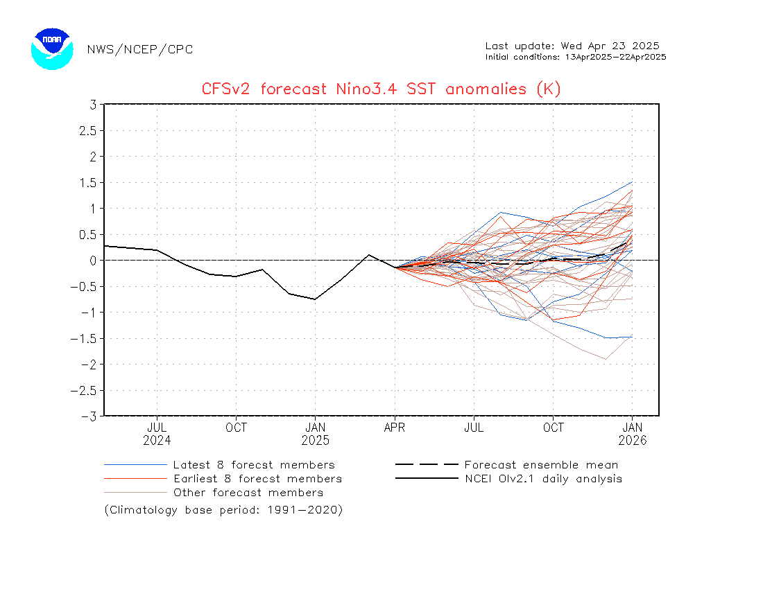
As mentioned in the heading>>>>>>>>>>>>>>The El Nino Beat is a bit stronger today…see CFS’s latest update: Remember, that some of our wettest winters were associated when the QBO was in its westerly phase like it is now and ENSO was at least Weak to Moderate….. SEE: http://origin.cpc.ncep.noaa.gov/products/people/wwang/cfsv2fcst/imagesInd3/nino34Mon.gif This is updated daily and can change as well but the trend has been moving in the direction of at least a Weak El Nino as of late. Weak El Ninos are not as favorable for the Central Sierra as they are for Southern CA, however there has been some wet weak El Ninos in Mammoth as well.
The Dweebs will be keeping an eye on ENSO now through the Fall because of the aforementioned…..
Dr Howard and the Dweebs…………………………………….:-)


