Brought to you by Howard Sheckter
Confidence increases that some light snowfall now possible Tuesday into Wednesday with another system bringing some additional accumulation Thursday/NGT
Sunday November 17, 2013
2:10PM Update:
CRFC showing Precip to hold off until tonight…
Tuesday Am Update:
Everything looking good for at least 5 to 10 inches of snowfall over the higher terrain by Thursday Morning…..Then we get what were going to get from the split-flow, spun up low heading SE down the coast Thursday/NGT. I would not want to be an LA weatherman as these closed lows are the kind of system’s that give weatherman the fritz. In fact I used to know of a LA weatherman by the name of Fritz…..Where do you think he got his name from?
LA gets a lot of these and they have a habit of flinging a loosely cooked egg on a WXMANS face!
They can bring some heavy showers to some areas and nothing to others. They can move too far off shore leaving LA with just a few showers or nothing….or…..get into the right spot with pouring rain, lightning and thunder. Usually they seeming wait until the forecast comes out then do one of those! Mountain weather is much easier to forecast….I think easier than LA Winter WX forecasting.
So here we are in Central CA…..with the mini “AR” approaching….PWAT are up to 1.75 according to SSMI. What is PWAT? Numerically it is precipitable water. Imagine a Column of atmosphere from the surface up to 30,000 feet. A PWAT of 1.75 inches is what you would get if you were to squeeze all the moisture out of that column top to bottom. Now with that said the question becomes as it relates to the current situation, are we going to get it all? NO. If there was a more dynamic atmosphere with 1.75 PWAT we would really get dumped on. For the most part we are going to get the effects of the moisture riding up over a cooler surface (Isentropic surface) then get the quick bump of the sierra for orographics to get precipitation. How much moisture we get out of that steam is a very tough forecast. However…..we more often times underestimated precip with these kinds of AR events then over-estimate. So the Dweebs are calling for 5 to 10 inches of snowfall by Thursday AM. Odds are it will be more……. Want to learn more about PWAT?? Download the following link from the NWSA. It is a good tutorial…. http://www.nwas.org/committees/rs/MicrowaveTPW_Nov06.pdf
When will it begin?? This afternoon…..
PS…
The Dweebs are beginning to believe that at least part of this winter, CA will experience “Several AR Events” (Tropical connections) There are some interesting clues to that as the pattern develop across the Pacific. So I would think that we will be looking at some pretty intense short period precipitation events this Winter, some of which will occur sooner than later…………..Stay Tuned……don’ t let your edges dull………….
Bye for now
The Dweeber………………………:-)
Monday AM Update:
Not much change in the forecast other than to mention that the snow level will begin about 7000 Tuesday morning then rise to 8000ft thousand later in the day and remain 7500 to 8000 Tuesday pm into Wednesday PM. The snow level begins to fall later In the day Wednesday as the main portion of the system and its precip move into our area Wednesday afternoon into Wednesday night. The 3rd system begins to split the pattern Wednesday night and so more showery weather is expected later in the night as the 3rd and last system spins up and tracks down the coast. In this fashion, we may be in for some upslope Thursday afternoon and night. If for some reason this system decides to take a different track through the southern sierra we would benefit from that track. However at this time….that is not in the forecast.
Total snow fall estimates….. 5 to 10 inches above 9000 feet by Thursday Morning and another 1 to 3 inches by Friday AM
PS….this snowfall estimate is not based upon any particular model guidance….It is based upon the consideration of the PWAT within the approaching moist air mass…isentropic lift and orographic’s that can have a positive effect on precipitation over and very near the Mammoth Crest. I have been burned on this one several times when little snow has been forecast and we get a foot! As I tell Clifford M. many times…… no Guts no Glory!
Longer Range Comments:
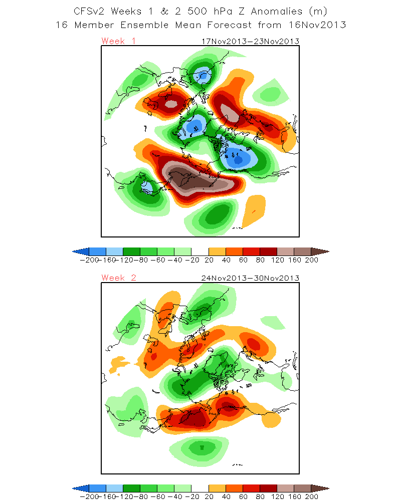
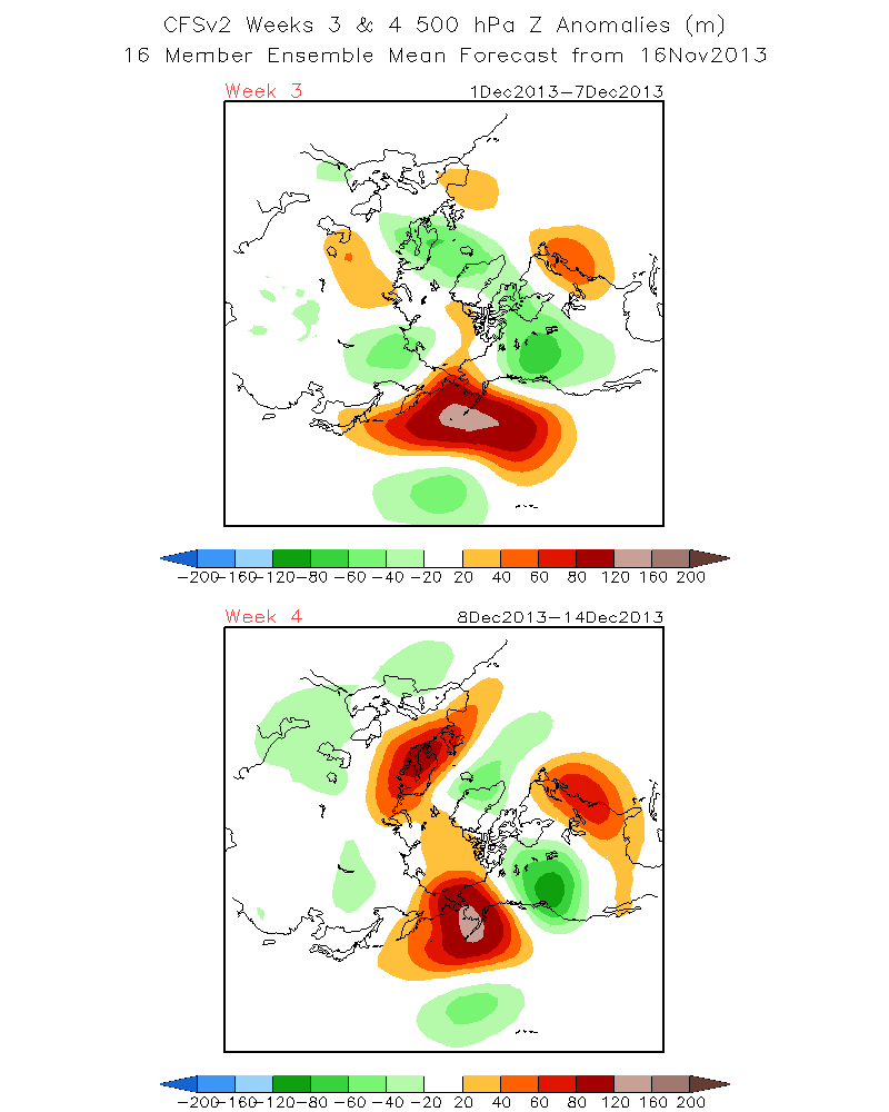
Recently the high latitude blocking has shown a tendency to be more east-west orientated keeping much of the cold air up into the Arctic. What needs to happen is for the blocking to be more meridionally orientated so to release the Arctic of its cold to the south. There is some hint of that in the coming weeks. But not until weeks 3-4. See: the CFS 500MB Positive Height Anomaly for weeks 1 and 2 ; then compare to weeks 3 and 4.
1st http://www.cpc.ncep.noaa.gov/products/people/sweaver/cfs_fcst/images1/wk1.wk2_20131116.z500.gif
then Compare to Weeks 3 and 4. http://www.cpc.ncep.noaa.gov/products/people/sweaver/cfs_fcst/images1/wk3.wk4_20131116.z500.gif See how the reorientation of the 500MB Upper height anomaly becomes more meridionally orientated during weeks 3 and 4. That would release the artic of its cold over the west. In fact…there is some suggestion of cross polar flow over the far west and down over the eastern pacific. Additionally, see the pool of green under the block. That is another little Kona Low that will set up another Tropical connection later with the west coast. IE Potential “AR” in December.
Dr Howard and the Dweebs……………………………:-)
Sunday AM update:
OK….this is the latest….
Evidently there will be three waves that will effect California next week The first two will be associated the old mid pacific closed low that is getting the boot out of that area by a strong subtropical jet. There is quite the moisture plume associated with that jet, with PWAT of up to 1.5 inches. However this moisture will not have any dynamics associated with it………………….TOO BAD!
So what he have is a very moist air mass that will ride over cooler air currently in place. We call this (Isentropic Lift) in this case. Plus there is some of the natural orographics of the topography that well get us some light snowfall out of it. 2 to 4 inches possible by Wednesday. This amount may be increased as it gets closer. The 3rd wave is now in the cards as a more dynamic system that will spin up as the upper flow splits near the coast line…….then follow the coast SE to Southern Ca.
This system so far is not expected to cross the sierra, and instead follow the coast line SE. Most likely it will not be a big precip producer for Mammoth. However we will get some additional light accumulations. If the system decides to kick inland to the south of us near the Tehachapi’s, upslope snowfall would occur and would add to the previous amounts.
So for the time being…..best guess between Monday Midnight to Thursday night at least 3 to 6 inches with the possibility of 6 to 10 inches if everything works out ok over the crest.
This is just an estimate. Will fine tune over the next few days……
For you folks in SO Cal….it is the 3rd system that could give LA some beneficial rains if the track remains SE down the coast Thursday Through Friday, It’s even possible that the system may get cut off all together over or near LA. More possibilities later as the model guidance improves and with more agreement.
Dr Howard and the Dweebs………………………………:-)


