Brought to you by Howard Sheckter
The Heat is On…..With deserts in the low 100s then Mid 100s this weekend…High Country Resort Levels in the 80s with Breezy Afternoons……Old MJO suppressed state over the Eastern Pacific so no Tropical Storms for a while…..Enhanced State weakening over the Western Caribbean…..Major MJO Entering Western pacific Soon…..
Tuesday June 16, 2015
It will be a warm, dry and breezy at times this week in Mammoth with an absence of thunderstorms. High temps will be in the high 70s Tuesday then low 80 through Thursday. The Weekend will be extra warm with highs in the low to mid 80s. Overnight lows will be in the 40s.
We are now well into Meteorological summer…..Even through the first day of Summer is next Sunday.
It was interesting to watch all the pre-season tropical storms spawn out of the ITCZ that moved up the coast from Mexico. Some of the moisture gave the Eastern Sierra and Eastern CA a lot of rainfall. Some areas got dumped on over the SW San Joaquin Valley.
Yes, the waters are warm with further warming expected over the eastern tropical pacific. But anomalous warm water like lots of tropical moisture does not mean rainfall unless the atmosphere is working and conducive to the rainfall process. Today the tropical eastern pacific is void of tropical storms in the same area that they formed just a week to 10 days ago. Instead, a tropical system is forming east of the Yucatan and will take aim on the Texas Coast before too long. Coincidence? No…. Areas of tropical upper divergence and areas of upper convergence are working to aid or suppress the process of tropical rainfall all the time along the equator.. Air Sea coupled systems like Kelvin waves, and the MJO move from west to east around the globe and ENSO in the base state. Over the past two weeks the convective phase of the MJO moved into the tropical eastern pacific creating a large area of upper divergence. (That is an area where the air moving away from itself in the upper troposphere) This large area aids in lift and makes the convective process EZ. This large area helped to spawn tropical storms that became Cat 4 hurricanes over the days following. That same area of upper divergence has shifted east and is now effecting the Gulf of Mexico east of the Yucatan. Behind it in the far Eastern Pacific is the systems counterpart, a large area of upper convergence which acts as a stabilizing force over the eastern pacific tropics.
Take a look at the following link. Blue areas are areas of high OLR (Outgoing Long wave radiation). An indication of the heat being released from the convective process. The brown area is cooler, as it is an area or low OLR associated with suppressed action and upper convergence. There areas move along the equator West to East and help to modulate tropical weather.
SEE: http://cawcr.gov.au/staff/mwheeler/maproom/OLR_modes/f.7.MJO.html\
Now for some tropical forcing systems in our future on an inter-seasonal time frame to watch out for…… (Timing is subject to change)
The following link is from the ECMWF Ensemble showing the updated MJO RIMM phase space showing the amplitude and location of the latest MJO. The Air-Sea coupled system is now moving over the Maritime Continent and in the next week, it will make a run for the Western Pacific. If this system gets strong enough, it may run into the Constructive Interference with El Nino about the first week of July. This may have happened in early March when a strong westerly wind burst initiated a powerful KV eastward that is now history today, and is possibly responsible for the current El Nino.
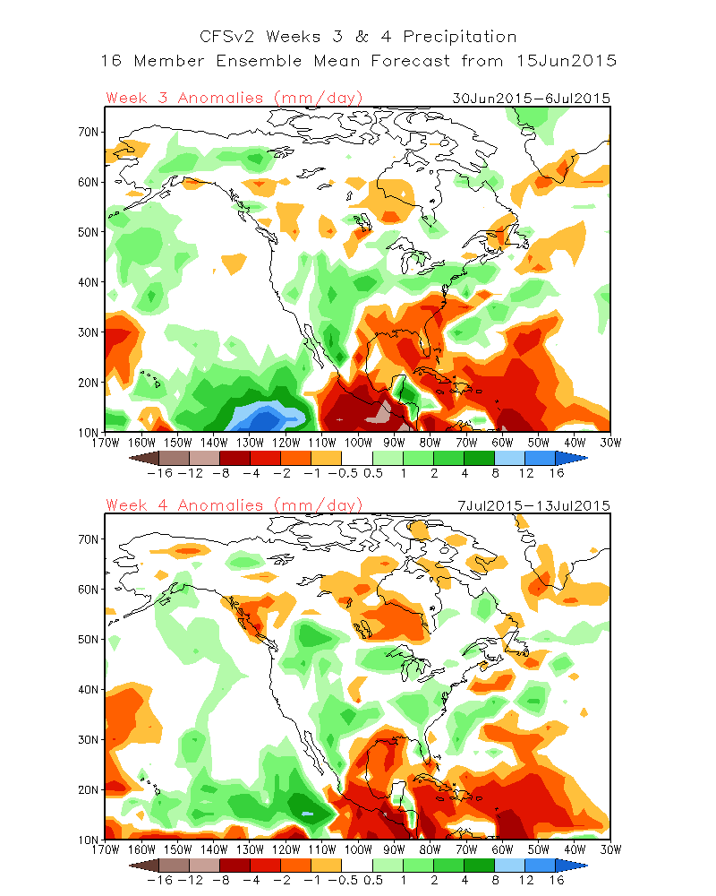
Beyond that time frame watch the MJO to see if it remains strong into Phases 7 and 8….the MJO’s convective phase will again move into the Tropical Eastern Pacific about the end of the first week of July, for another possible Rain and Storm Event, for Mexico, Baja, The Desert Southwest and possibly Southern CA and the Eastern Sierra. I would expect the pattern of Tropical Upper Divergence to modulate and intensify the SW Monsoon, beginning during the first week of July into the 2nd Week of July. (Note the intense area of convection week 3, near 10N-125W)
See: http://www.cpc.ncep.noaa.gov/products/people/sweaver/cfs_fcst/images1/wk3.wk4_20150615.NA.gif
Note, the ECMM Ensemble version of the MJO phase space below…where it is today, and where it may be headed over the next 2 to 3 weeks….
http://www.cpc.noaa.gov/products/precip/CWlink/MJO/CLIVAR/ecmm.shtml
ENSO:
The latest NINO3.4 forecasts (initialised in June) indicate the central tropical Pacific Ocean is likely to continue to warm throughout the winter and spring months. The average of the model forecasts for September is just above +2.0 °C, increasing to +2.3 °C by November. NINO3.4 values of this magnitude have only been observed on a handful of occasions since 1980; during the 1982-83 and 1997-98 El Niño events. Individual model output ranges between +1.6 °C and +2.8 °C for November; all well above the El Niño threshold.
The most recent NINO3.4 value is +1.3 °C for the week ending 14 June 2015. NINO3.4 values above +0.8 °C typically occur during El Niño events.


