Brought to you by Howard Sheckter
New Development over Western Pacific lends confidence to progged Storm in the Week Two forecast period….More below…..
Sunday December 6, 2020
Dec 9th….
After a day of high clouds….with little change of temps, winds will increase Thursday as an inside slider approaches and moves through our area Thursday night and Friday AM. It will be a chilly day Friday with highs in the 30s with breezy weather. Measurable precipitation chances are slim and none but a few flurries are possible by occur late Thursday night. Our pattern over the eastern pacific goes into transition with a moist zonal flow taking aim on the Paicific NW this weekend. Overrunning moisture will bring some chances of light snow over the upper elevations both Saturday and especially Sunday. Sunday looks to be the best day for anything measurable. A few inches of snow may fall over the upper elevations. Daytime Highs will be in the 40s this weekend. Next weeks outlook does continue the idea of the upper jet to our north. Once again, some light over running precip may fall on Mammoth Mountain. At this time, the overall pattern is highlighted by the upper jet remaining well to our north. As a consequence, no major storms are likely next week.
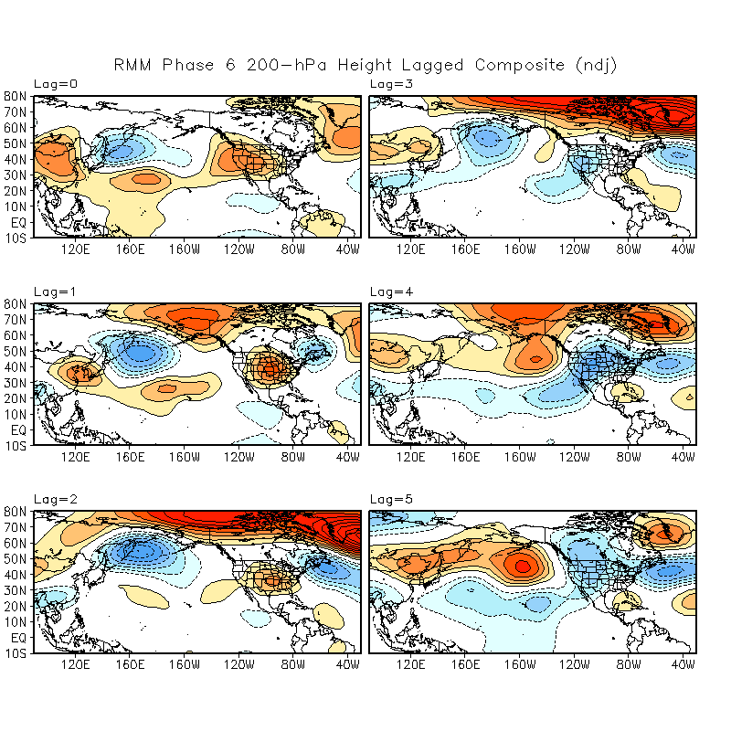
Longer Range: This mornings GFS Phase diagram shows the MJO moving from Phase 5 to 6 week 2. This is a new development which certainly has some interesting possibilities toward the end of the year. Take a look at the composites for Phase 6 and especiaslly the later lag panels showing a cold trof setting up over the intermountain west, later week 2 and into week 3. While the cold trof does not suggest a major storm, it does suggest colder weather, more meridial flow with some over water trajectory. This is the period between Christmas and New Years. SEE: whmjo6.ndj.z200composite.web.png (800×800) (noa You can see in the composites, that lags 3 , 4 and 5 show a Trof in the west…There is also some increase of ensemble members showing some good strength and even some suggestion that a jump to Phase 7 may be possibe which would turn our weather wet here in the Central Sierra…..
SEE  Current GFS Phase Space:
__________________________________________________________________________________________________________________________________________________________________________________________
Tuesday AM Dec 8th…..
John Lennon of the Beatles would have been 80 years old today had that wack-o not shot him in the back some 40 years ago today. The world was truly robbed from his future great music writing and singing and possibly future comments about the state of current world politics.
La Nina is offically in the Moderate to Strong range at an average of -1.3C according to the IRI and CPC. The threshold for Strong is -1.5C in the Nino Region of Nino 3.4. Whether this La Nina reaches the Strong Criteria or not, it has been clearly a Dry Fall here in the Eastern Sierra. In fact, one of the driest on record. The last measurable rainfall in Bishop occured on April 17, 2020. Today is day 235 day since that day. That breaks the old record of 199 days. Judging from the number of days Bishop has had no rainfall, I believe that that is testament of how dry this year has really been.
In looking at the Climate forecast system, they do give the sierra well needed snowfall between the 21st and the end of the year. However, based upon the current ENSO information, there are very strong forces working against those predictions. Cold SSTAs from the Dateline westward is strongly weakening tropical convection, destructivl;y interfearing with the MJO and other tropical modes of variability. Although mid latitude teleconnections can influence our west coast pattern, and they have not been favorable to date; May it be that this moderate to strong La Nina that is the tail that is wagging the dog? Food for thought….
Monday AM the 7th…..
Models not much help this morning. GFS has a signifacant wave coming through on the afternoon and evening of the 16th and another on the 20th. The best Western Pacific support via Hovmuller study, would be for the energy to come thorugh on the 16th. The Europien model is not nearly as robust with the wave. It does migrate the upper jet south into Central CA, and greatly weakens it. Both models do a lot better for the Northern Sierra as far as QPF. As in my discuession below, the MJO is very weak and over the far Eastern Maritime Continent. So support, teleconnection wise, is not great from the MJO. WIll keep a weary eye on developments this week for next week….
Dr Howard and the Dweebs…………………….:-)
__________________________________________________________________________________________________________________________________________________________________________________________________________________________________________
Recent global model runs of the GFS and ECMWF are developing a strong short wave trof into California between the 16th and the 18th of December. This is a realitivly new development, however, there is an increasing number of ensemble members progging it. The system has a good Atmosipheric River attached to it and so it would be a very benifical precipitation producer for much of Northern and Central CA.,
What I like;
-
- Next Sunday, a Super Bomb develops off the coast of Japan, (rapidly deepening surface low) as a cold airmass moves off the Coast of Asia. The Surface Pressure Maps for Dec 13 to the 14th bomb this low out to 28.10 in!. WOW. The system is developing below a 180knot upper jet at 250MB. This propagates the energy east to the west coast between the 16th and 17th of December via Hovmuller study. So what this does for the forecaster, is give the storm for the west coast betwen the 16th and 18th support for future varification. The models also devcelop an AR with the CA short wave, so there should be at least moderate amounts of snowfall here in the Central Sierra. As far as QPF goes, in my opinion, its too early to guess.
What I don’t like:
2. The MJO is very weak and is located in an area over the Eastern Maritime Continent, which usaualy teleconnects to a +PNA. (Ridge over the West) The MJO signel may actually just be typical convection over that region.
So to add this all up, its likley that we will have at the least unsettled weather during this timeframe. Should ensemble members continue the trend, it may be our first major storm for our Eastern Central Sierra!
In thre meantime, a small low pressure area is bringing gusty winds over the Sierra Crest today and Monday. It will be cooler Monday. There may be a few flurries or showers later tonight and Monday. Mondays high will be near 40 degrees with lows in the teens.
Another system may bring strong winds to our area Thursday next week along with some showers and yes…Cooler temps.
Stay in touch with Mammoth’s most Experienced Weather site!
Dr Howard and the Dweebs………………………..:-)


