Brought to you by Howard Sheckter
Weak AR moving out this morning with Moderate amounts of Snowfall on Mammoth Mt….Strong Ridging expected Wednesday through Sunday with Above Normal Temps expected
Tuesday November 9, 2021
11-10-21 Update
Total Snowfall as reported by Mammoth Mt 9 to 11 inches;
Pattern change underway with Upper High off shore building into California this weekend with much warmer than normal temperatures expected. The upper ridge is expected to begin flattening Tuesday as a weak extension of the westerlies shifts south. The pattern middle of next week suggests cooling, clouds and breezy weather. A few showers are possible. “At the moment”, there is little in the models suggesting a significant storm before Thanksgiving.
Dr Howard and the Dweebs…………………….:-)
____________________________________________________________________________________________________________________________________________________________________________________
Our weak AR now moving out of our region leaving up to a foot of snow in the higher elevations. The Dweebs will update on the final tally later. There was one to three inches of wet snow in the residential areas of Mammoth. this AM.
The weather will be fair with a warming trend through weeks end beginning Wednesday. Highs today in the 40s with highs in the low 60s this weekend. Winds will be diminishing through out the day today and into Wednesday.
Over all, the forecast was somewhat of a bust as the QPF was all over the place for our area. One of the big reasons I believe was in the models handling of the deepening Trof north of Hawaii and resulting height rises west of Baja. This was always in the models, however, its timing was a bit quicker. In the end, the results was less precip and a quicker exit as well as stronger height rises west of Baja, MX. The 588DM iso height line pushes into Mammoth Saturday AM for an exceptionally nice mild day. Highs in Bishop may hit low 80s as suggested a week ago. Get your T times early!!
The week 2 outlook suggests a flattening of the long wave ridge and the westerlies shifting south again middle of next week for an increase of wind, cooling and clouds.. There is a short wave and upper jet that pushes into the Pacific NW next Tuesday and Wednesday. The upper jet slides mostly east while it shifts slightly south into far Northern CA, so maybe some showers up there later next week?
There are some operational runs that shift the short wave south enough to affect Central Ca but that is not the thinking at the moment. What is being considered is short wave length type amplification the week of thanksgiving and the “Possibility of a Great Basin Low with colder weather. Although there may be some light snowfall with this pattern, it is regarded as a dry pattern. The suggestion of a NNW Upper Jet over CA around Thanksgiving along the coast of CA will certainly bring a chill to our area and at some point, north winds for the Owens Valley.
Climate:
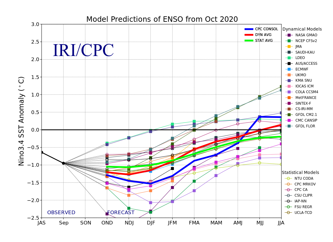
I thought it might be if interest to those that track La Nina to compare the IRI Oct 2021 to October 2020. This La Nina is on track to be weaker. I like that. I hope we get some follow through of a robust MJO into the Central and Eastern Pacific….Wishful thinking.