Brought to you by Howard Sheckter
Archive for January, 2022

Forecast Outlooks remain dry through the next two weeks…Encourging signs from Tropical forcing developing after Mid February……
Saturday January 29, 2022
Groundhogs Day>>>>= mid point of Winter
Here is an excerpt from the CPC on tropical forcing and the emergence of an MJO. I think that this is all positive in the long run for a productive pattern shift. However, It may not happen for 3 to 4 weeks out though.
From the climatic prediction center; CPC
There are some indications of a large-scale eastward propagating enhanced convective envelope that has moved from Africa to the Indian Ocean since mid-January; however, this signal is currently masked by remarkably strong ERW activity over the Indian Ocean. Over the Pacific, weak westerly anomalies over the east-central Pacific reflect a continued disruption of the atmospheric response to La Nina conditions, though trade winds have become increasingly enhanced near and west of the Date Line, which may be due in part to the emerging intraseasonal signal. Dynamical model MJO index forecasts are fairly consistent and show a rapid increase in amplitude over the Indian Ocean, which may reflect the emergence of the MJO signal from ongoing ERW disruption. By Week-2, many GEFS and ECMWF ensembles depict a “hairpin turn” of the RMM index, favoring a resumption of eastward propagation across the Maritime Continent. This sharply turning feature is frequently indicative of strong ERW activity modulating the MJO signal. In contrast, a growing number of alternate ensemble members show a slower evolving and higher amplitude signal over the Indian Ocean, which may be a response to Indian Ocean tropical cyclone activity. Based on these recent observations and dynamical model forecasts, the MJO is favored to become increasingly active over the next two weeks, and will likely play a role in tropical cyclone development, the orientation of the monsoon trough over the Maritime Continent, and potentially “the downstream midlatitude pattern”.
______________________________________________________________________________________________________________________________________________________________________________________
1/30/2022
I realize that this is very esoteric, so please bear with me.
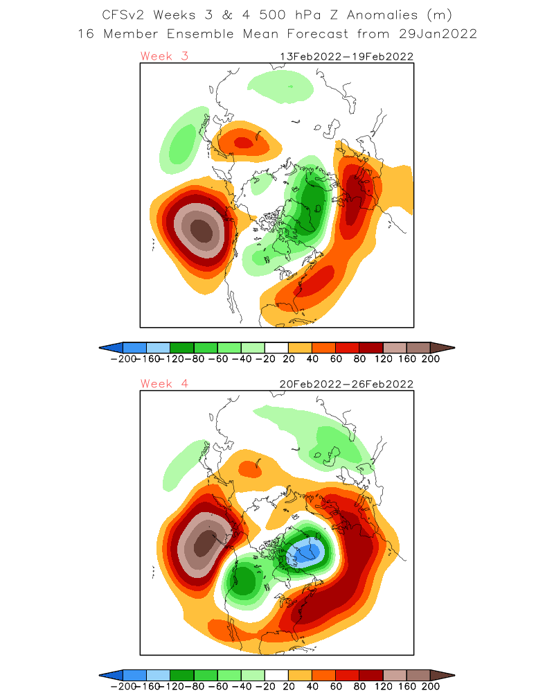
Here is the CFS from earlier today. It shows a trough for the west coast for week 4, or the last week of February. This gives support to the idea of the potential of a storm cycle, beginning the very end of week 3 and the last week of February, like my last discussion..
__________________________________________________________________________________________________________________________________________________________________________
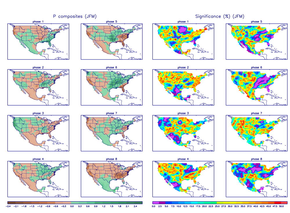
MJO Precip composites for February, Note phase 3 at JMA
left, which is wet for CA.
The Forecast and outlooks remain dry for the Mammoth area well into February. There is a cold Great Basin slider that may produce a few snow showers late Tuesday into Wednesday AM, It will be turning colder and windy Tuesday into Wednesday. Thereafter the upper ridge is expected to snuggle up against the west coast the following weekend for milder weather. The following week looks dry.
Lets all have some weather fun today by participating in a little long range experiment.
At the moment, according to both week one and week two global models, it all looks dry as far as the eye can see. However, there are some experimental tools that we can use to hypothesize a change to a wetter pattern some 3 to 4 weeks out.
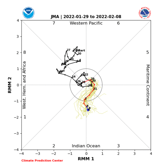
In the Month of February, there is a strong signal associated with the Madden Julian Oscillation that teleconnects with precipitation over the state of California. The signal now in the circle forecasted by several models, with the above example using the JMA, (Japanese model) shows the MJO emerging into in Phase 3 of the Wheeler Hendon Phase space, toward next weekend. Phase 3 shows wet for California in February.
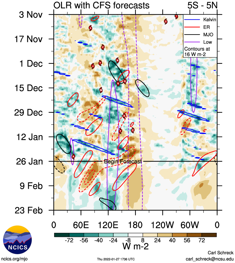
Below, the OLR with the Climate Forecast System suggests the emergence of MJO the end of the 3 week of February. Its possible that this signal may modulate the westerlies later in the month of February. Look for Retrogression as early as the end of the 2nd week of February with the development of a Pacific storm track toward the end of the 3rd week of February or just beyond. Again, this is just for fun. Let see how it all works out!