Brought to you by Howard Sheckter
A Flip in the Hemispheric Pattern to +PNA will give us our January Thaw toward Mid-Month….A great time to enjoy all that December snowfall!!!!
Monday January 3, 2022
Jan. 11TH
Pursuant to the last post, it is evident that there will be no major off-shore event for SOCAL on Friday. Nevertheless, there is one occurring now with warmer temps expected Wednesday. The upper low SW of Southern CA gets picked up early next week for a few showers in the LA area weeks end. There is likely going to be another forming to replace it later next week. It all adds up to a dry pattern with variable high and mid level clouds for the Sierra into next week. The outlook is dry for the next 10 days.
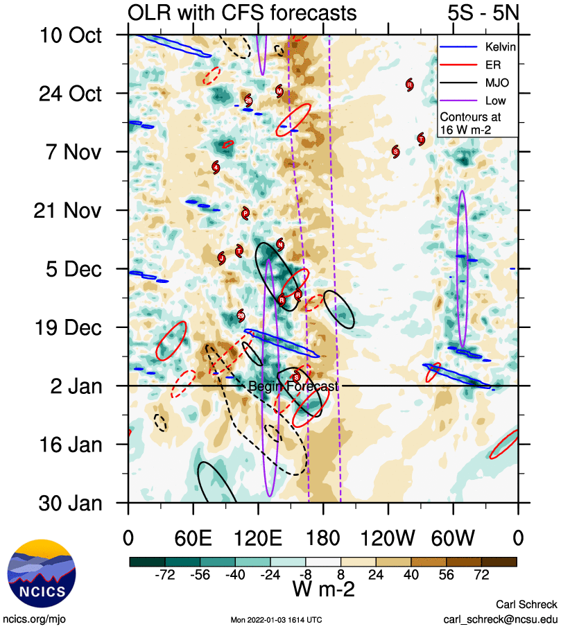
The big driver for big weather all revolves around the MJO I believe and where its going to go. If it circles back around to phase 7, were off to the races!! I think it will be a lot more evident net week. Still expected big changes, during the last week of the month of January. As always stay tuned……………………….:-)
Dr Howard and the Dweebs………………………:-)
_________________________________________________________________________________________________________________________________________________
January 5th-2022
Not much to add to the discussion below. The last system in the series is actually left over from the previous pattern. That will be coming through this Friday. Expect very light amounts of snowfall, (1 to 3) inches.
That system will leave a cooler airmass for the weekend, with high temperatures returning to the 30s with overnight lows once again in the teens and twenties. Moderate to strong winds will pick up over the ridges beginning this Thursday night into Friday. The storm will exit Friday night and leave a beautiful weekend as an upper ridge, developing in this new pattern builds over the west coast. Expect temperature inversions to strengthen with the possibility of Pogonip Fogs (Freezing Fog) near high elevations large area lakes, mainly in the high elevation valleys developing over this weekend.
The next weather feature in our long range outlook occurs next week as another short wave from the westerlies splits and spins up as a closed low well off the Central CA coast early next week. The upper low eventually forms a mid latitude REX Pattern as high pressure builds into the Pacific NW to the north of it about Friday the 14th.
This pattern this time of the year is notorious for strong gusty easterly winds over the Sierra Crest, in this case for the 14th. It can also set up a strong off shore wind pattern for Southern California. (Santa Ana’s)
A mid latitude Rex Block “in this case”, develops with High Pressure aloft and at the surface pushing into Northern California NW, couples with low pressure centered well to the south of it. Both the Sierra and Southern Ca are sandwiched in between these two anomalies and the end result is strong winds; 1. Strong east winds over the sierra crest and strong NE winds blowing off shore from the High Deserts of Southern CA to the coast via the Local Mt Ranges. The timing of this at the moment is Friday the 14th, if this pattern verifies! Incidentally, there are some deviations that can occur with this pattern that can give the eastern slopes of the sierra precipitation. If the upper low sets up north of Vegas, Upslope snowfall could happen for the Eastern Sierra. However, at this time, the outlook shows the former pattern which is more common.
All in All it looks like a great MLK weekend weather wise for Mammoth. If strong east winds do develop, the strongest winds would be confined mostly to the lip of the Sierra Crest. The gradient is expected to relax over the weekend.
Longer Range;
The GFS is hinting at the possibility of a Sudden Strato-Warming event around Mid Month. Stay Tuned!
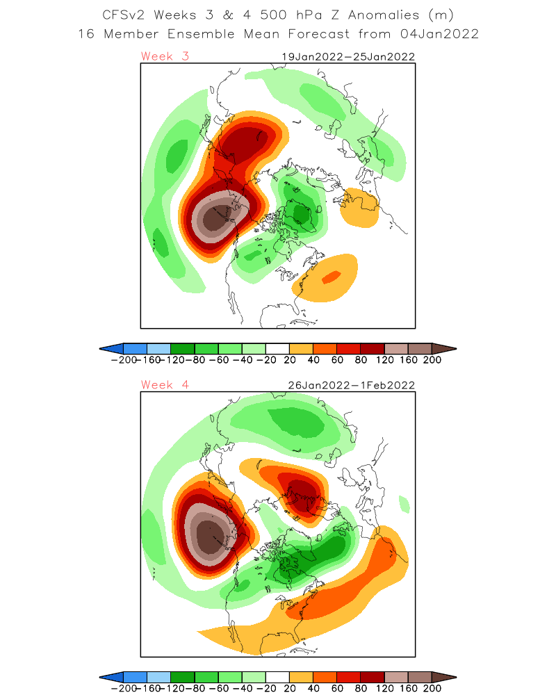
The Climate Forecast System (CFS) is currently showing a break down of the current pattern during the last week of January. It suggests a -WPO with positive height anomaly centered over the Western Aleutians. This suggests a more southern storm track for the west coast. Again as mentioned many times in earlier posts, this is not a forecast, just an interesting curiosity.
SEE:
Bye for now…………………….
Dr Howard and the Dweebs………:-)
_________________________________________________________________________________________________________________________________________________________
How quickly mother nature can turn it off! This week a transition occurs from Decembers Ridge-Trough pattern over the Central and Eastern Pacific, to Trough-Ridge. That along with the flipping of the typical La Nina, North American Circulation Patten to the positive phase puts an end to our active wet pattern for the next few weeks this month. Sure we can still get a few storms, but its doubtful anything major. Time to get out and to enjoy all that great snow from December! This weeks weather shows the last storm that moved over the North Pacific Block getting ripped apart east west, as strong height rises occur from the south. Expect mainly winds the next few days with fair warmer weather Wednesday and Thursday. There appears to be another short wave dropping down from the Gulf of AK, but it is questionable on how much snowfall we may get at this time. It is sort of running into a train wreck by the time it gets here. Hopefully we get an inch or two to freshen it all up for the weekend of the 8th. Daytime highs will be in the 30s and 40s with lows in the teens and 20s…
As far as weeks 2 and 3, Looking at the MJO, there are mixed signals. The CFS weakens it rapidly then progresses it along the inner circle through phases 8 1 and 2. Both the NCEP and ECMWF weaken the signal over the next week or two. Not any help. The composites would suggest that if the MJO remained strong in phase 7 and 8 during the end of January and throughout February, we would expect a return of an active pattern.
I think that most importantly, the MJO Re-Emerges back out over the Central Indian ocean after the 16th and toward the 23rd; see the latest OLR with lasted CFS forecasts. Another flip in the PNA back to negative, might be expected toward the end of January.