Brought to you by Howard Sheckter
Coming into the Home Stretch of January….Crystal Balls anyone?
Monday January 24, 2022
1/28/2022
Hope on the Horizon…..
Here are some thoughts of mine that are encouraging about a pattern change for snowfall potential for the month of February.
As mentioned earlier, storms from the pacific are shut out for the foreseeable future.
The Eastern Pacific High must love the west coast because it is pretty much snuggled up against it! It will retrograde slightly Sunday into Monday and amplify then allow a cold Great Basin slider to bring Wind and cooling Monday night into Wednesday, followed by the progression of that ridge into the west coast the following weekend. The slider will bring unsettled WX with even the slight chance of a few flurries or light snow showers Tuesday/Ngt. Nights will cool to the single digits by early Wednesday AM.
The following weekend will be mild and dry with above normal temps.
Highs will continue to be in the 40s then upper 20s Tuesday then low 50s by the following weekend.
MJO:
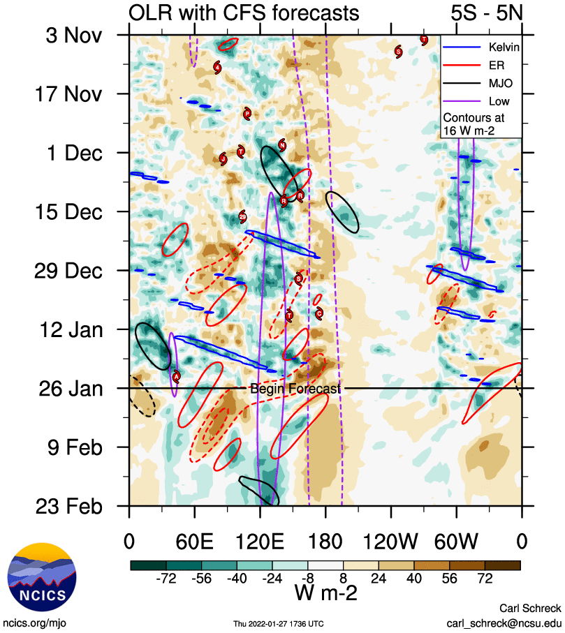
Excluding the ECMWF model, the GFS and the JAMA models are showing the MJO emerging over the Indian Ocean later next week. The Wheeler phase space suggests phase 3. Looking at the “Hovmuller” OLR CFS” you can see the Possibility of a Significant MJO emerging, one that may retrograde our mid latitude pattern and amp the EP ridge much further west, between weeks 3 and 4. SEE Hovmuller time series graphics here along with OLR. The Green/ Blue shading near 120E is of note. That is significant I believe.
Timing would be in the week 3 range, or a transition around mid February The MJO precip composites for February in phase 3 are encouraging as well.
____________________________________________________________________________________________________________________________________________________________________________________________________________
I have had lots of folks asking me lately that, “is this the end of Winter”? What I say is that no, It’s not even February yet! Even so, folks are still having withdrawal’s from an intoxicating December, from more snowfall than they could remember! I have been posting the past week from a perspective of lots of back peddling! I realize that the Global forecast system, “GFS” has had the effect of getting the “Wet Foots” all excited about a big first week of February snowfall wise. I saw the QPF from the GFS last night, 2 to 3 feet next week, but I have not been buying into to it! For me, the big reason is that the MJO is stuck in the circle of death, meaning that; 1, Its very week and 2 Not supportive of a wet week next week at all! Of course, the MJO is not the only teleconnection that can force mid latitude circulation, however, it’s a big one and when you do not have the support of Old Julian and Madden, to me, your flying in a cloud without IFR. 🙂
Again, there have been several forecast model runs of the GFS that are/were exciting, but the Dweebs have not been biting. The European, has not been in its camp and for good reasons. The Dweebs are still looking at a pattern next week that will be cold, Potentially very windy, and yes, the possibility of some light snowfall, from what ever moisture there is, either coming down north to south through California or through the Great Basin, squeezed SW as upslope.
With all that said, the pattern potentially, will be very exciting wind wise! Mono Wind Event possible?…. Later in the week I will come up with snowfall guesstimates.


