Brought to you by Howard Sheckter
Archive for February, 2022

Warmer Temperatures expected for the upcoming week with the next change a chilly slider through the Far West…..Long Long Range still looks very Encourging for Pattern change to wet during last week of the Month….
Sunday February 6, 2022
2-13-2022
The long awaited retrogression has begun in the models….
The upcoming week will be exciting in seeing how the new pattern develops during the outlook period, as pacific storms return to Ca again.
Stay tuned!
Dr Howard and the Dweebs…………😉
___________________________________________________________________________________________________
2/9/2022
The best news coming out of the CPC discussion yesterday is that; MJO is expected to “Constructively Interfere with the La Nina Base State toward the end of February”!!
Note: This is what happened in early December.
Enjoy the warm weekend! Mid 50s in Mammoth, Low to mid 70s in Bishop, high 80s Death Valley and temps as high as low 90s in some area of SO-CAL. IE, record highs….
The Dweeber…
_____________________________________________________________________________________________________________________________________________________________________________________
Its been a very cold winter for Mono County. Once the county had snow cover, days and nights temperatures have been mostly below normal. I see some of the warmest temperature’s so far this Winter developing for the New week with 70s in the Owens Valley and 50s in Mammoth. With Sun getting higher in the sky, it will feel wonderful!!
The Models are pretty consistent with the next significant short wave for about a week now. bringing cooling, wind and possibly some snow showers.
Longer Range:
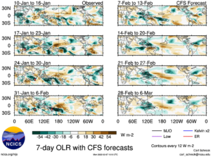
Since the latter part of January I have been bullish about a flip in the Hemispheric Pattern due to the emergence of MJO over the Indian Ocean (IO) Nothing has changed in my thinking. Here is a possible scenario;
- A dry warm week this week
- A chilly inside slider around the 15th that will bring wind, cooling and maybe some light snow.
- 3rd week of February will be the transition week with strong tropical forcing developing over the (IO) and MJO along with ERW cranking up. Phase 2 into Phase 3. of the RMM.
- Long wave trough to carve out over the eastern pacific between the end of the 3rd week of February and end of the month. Then stormy WX , developing 4th week of February into March.
- See what appears to be twin anticyclones aloft (Upper Divergence) on each side of EQ moving toward favored Phase 3 last week of the month.


