Brought to you by Howard Sheckter
One more Major Snow Storm is expected Saturday through Tuesday AM….Then pattern trends dryer colder through that following weekend
Wednesday January 11, 2023
1-13-2023 1:15pm
Interesting look at the longer range
According to the RIMM Phase space, The MJO will be moving into Phase III which is wetter for CA than phase II
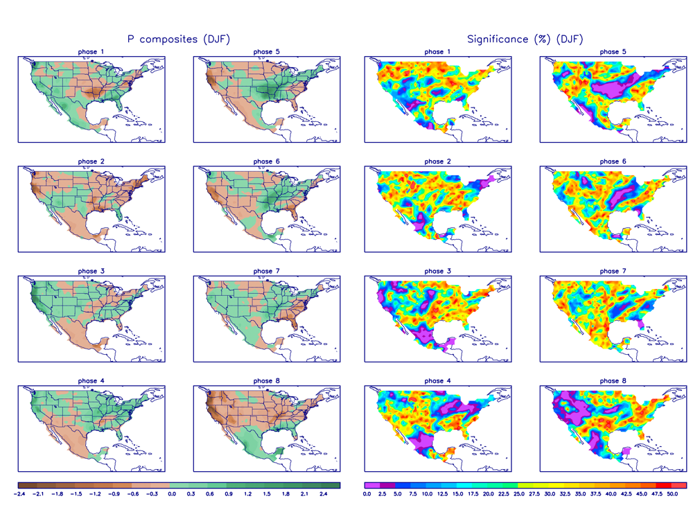
See the composites for the MJO phase space for January. The week two GFS and ECMWF has retrogression around that time and storms over the eastern pacific approaching CA.
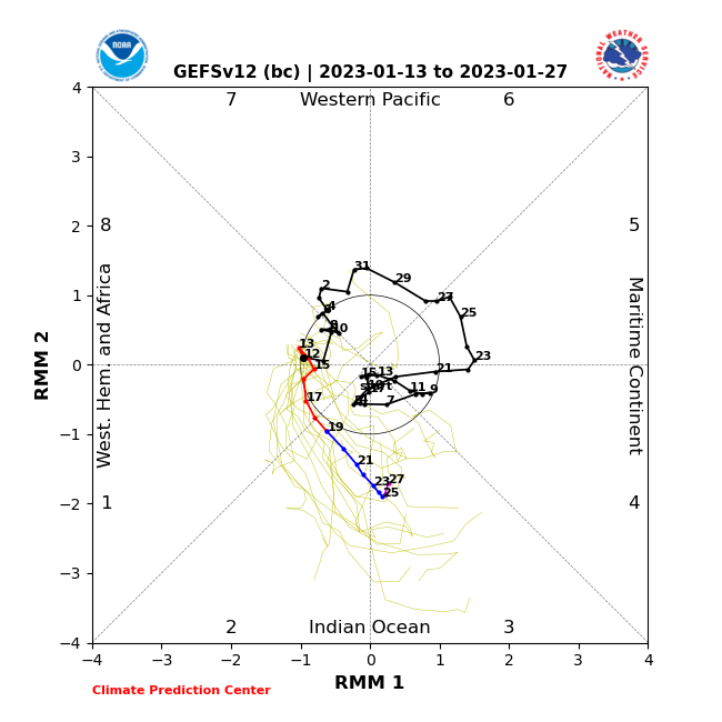
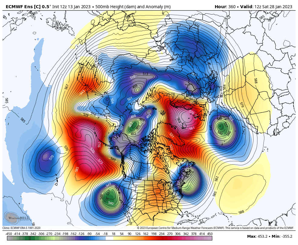
This is not a forecast, rather just an interesting coincidence from the RIMM to what the Euro is showing 360 hours out or around the 26th to 28th of January.
1-13-2023 11:00AM
AM Update;
There are three periods with the pattern that are of interest;
- Light Warm Frontal Precip that has already developed today for a few inches that will continue into tonight with some additional 3 to 4 inches of snowfall possible. Amount’s are for the town.
- The next and heaviest precipitation producer moves in later Saturday AM with heavy snowfall into Saturday night. Some 1.5 to 2 feet is possible in town by early Sunday AM
- Sunday actually show more of a break in the intensity of the pattern with lighter snowfall accumulations.
- The next and perhaps strongest portion of the pattern without as much moisture to work with, moves in Later Sunday night. This storm has a surface low that comes right across the SFO Bay area. So it will be quite dynamic and produce heavy snowfall Monday AM with potential white out conditions in the Morning!! The heaviest snow fall will taper off during the afternoon with snow likely into the early AM hours Tuesday.
- The Dweebs are still expecting over 3 feet in town and 4 to 6 feet on the mountain total by Tuesday AM.
- I will update the QPF this afternoon.
1-12-2023 10:25AM
Here are some very interesting Stats from today’s DWP Update;
- Southern Sierra on track for Wettest Winter in the past 40 years..
- Southern Sierra has an average of 276% of normal to date with 30 inches of water in snow pack
- Southern Sierra is 132% of normal for the entire water year
- Bishop is 374% of normal to date with 8.49 inches of water
- Bishop is 136% of normal for entire water year which ends September 2023
Mammoth Pass;
- Mammoth Pass has 40 inches of water to date.
- 40 inches is 94% of normal for the entire winter
- 40 Inches is also 201 % of normal for the date.
- DWP which is were this report comes from, indicates that we are ahead precipitation wise of any year on record.
Patterns in transition are difficult to nail down.
Just Looked at the ECMWF ensembles through the 25th and it shows a much drier pattern with the ridge building initially at 125-130W. With this scenario, we may get a chilly inside sider Thursday, but overall just some snow showers Thursday, followed by a dry weekend. It shows a strengthening ridge holding this weekend through next Tuesday the 24th. Thereafter, retrogression is indicated with the upper long wave ridge pushing back to 140W to 145W. This may open the door to some cold systems moving down the coast without ARs late in the month.
The latest GFS Ensembles has almost the same scenario, so confidence is high that a nice long break is ahead of us beginning next Friday through at least mid week the following week.
Next 5 days:
We have one more AR to deal with. It is a CAT 3. So plenty of moisture.
It is interesting to note that the big Trof to the west of us will rotate counter clockwise and become negative tilt Friday for some over running precipitation. Eventually the flow becomes zonal as a short wave drops in the back side of that system. The system stretches West-East as the AR moves in Saturday. This should be good for Heavy Snowfall Saturday afternoon through the night. A final short wave moves in late Saturday night and is followed by much colder and unstable air for continued snowfall Monday. The back side of this trough moves in Tuesday AM, and light snow showers are indicated that day. So the wet pattern comes to an end.
Although there are are some model simulations that show a few cold storms the following weekend, the ensembles shows that it is unlikely to happen. Thus at this time, the Dweebs are going dry the 20th through the middle of that week…The 26th.
PS, Mammoth Mt could pick up another 4 to 5 feet by next Tuesday AM. 2.5 feet to 3.5 feet in town.
The California Rivers Forecast Center this afternoon shows 6.61 inches of water for Huntington Lake, beginning later Friday through early morning Tuesday. Tuesday looks dry Next Week.
Dr. Howard and the Dweebs………………:-)


