Brought to you by Howard Sheckter
Milder Temps on the way for the weekend with considerable high clouds……MJO now in favored 7/8 RMM phase space for retrogression of East Pac Ridge….Retrogression showing up in Global Models now over North Central Pac beginning this Monday the 20th…..A stormy week to begin about the 21/22st….
Thursday February 16, 2023
2/18/23
Saturday AM Quick update;
After a dry and milder weekend in the high country, the next active pattern will begin this Tuesday with increasing wind and the chance of light snow. Winds will be at least at advisory levels Tuesday night. This 1st storm is an Arctic Storm with once again “CPK” air from the NW territories of Canada. This means that it will get cold again like it did last Tuesday with highs in Mammoth in the upper teens and lows below zero. The East Pac High will be in retrogression across the Central and Eastern PAC. So weather systems will develops further off shore and become wetter at months end into 1st week of March. Of Note, the models at this point have backed off on the idea of an Atmospheric River. Thus precipitation totals are half of what they were touted a week ago for the next week or two. The precipitation forecasts (QPF) are now up to about 7 to 8 inch range (70 to 80) inches of snow over the crest over the next two weeks. Should the Eastern Pacific Ridge become more positively tilt, that could would change the QPF forecast.
About the Arctic Express….
More 3 Dog Nights Ahead!
This has been one of the coldest winters in memory! The next Arctic Express will push its Ribbon through our area during the night Tuesday. 1000MB-500MB thickness are progged down to 518DM Wednesday AM over Mono County. These thicknesses remain in the 520DMs through Friday AM. (Exceptional!) 700MB temps range from -13C to -17C Wednesday AM through Friday Night.
Any snow that falls during this period will be at ratios 15 to 20:1! True “Platinum Powder” and Northern Rockies Quality!
The Next Cold system drops in the night of the 27th with more CPK air. There is more over water trajectory with it so there will be more snowfall and it will be the fluffy type snow. It will begin Monday afternoon the 27th and continue through Tuesday the 28th. At the moment there is a break March 1st through the 5th.
More Later……………………….
The Dweeber………………………:-)
____________________________________________________________________________________________________________________________________________________________________________________________________________
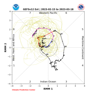
The Dweebs have been posting about the MJO in RMM Phase Space 7/8 since February 11th in regards to the potential for retrogression of the Eastern Pac High. The MJO (Madden Julian Oscillation) is a great tool during the winter as this climate mode can give lots of lead time for the next active pattern for our area. This tool on an intersessional time scale, is not an absolute tool to modulate the westerlies. However, more often than not can foretell of a significant pattern change for the Sierra during the Winter and most of all, can lend support to whether the week two models are on the right track..
This mornings RMM update posted below has an interesting twist to it. While the MJO is now in phase space 7/8 foretelling retrogression, it weakens then reemerges strongly back into 7/8 later in March. There are different modes of air-sea coupled systems creating upper divergence and upper convergence aloft over Indian Ocean, and down stream hemispherically. Modes include Equatorial Rossby Waves that travel East to West, Kelvin Waves that can push ocean subsurface warmth West to East and of course the MJO. Those that are interested should research these tropical modes of variability on the Net as this science is on the cutting edge of longer range forecasting, not only for Tropical Storms but their effects upon mid latitude circulation.
Look how the tracking of an MJO in Phase 7/8, dives into the circle of death later this month. Then another mode of tropical variability reemerges in phase 6, then progresses into 7 and 8 again about the middle of March. Phase 6 is usually drier for Northern California in March. Then Phase 7/8 can become wetter based upon the Lagg Composites. At this time, no one knows for sure what kind of mode of tropical variability it will be. That is; if this is an EQ Rossby Wave, MJO or possibility a big Typhoon over the Western Pac.
If it is an MJO; in March, the composites favor Southern CA in Phase 6, with low pressure off their coast. When in phase 7 then 8, the storm track becomes more active further north for Central CA and Northern CA.
As we know, phase 6 has been been very cold for the Eastern Sierra with little snow. This was the weather for early February, not March.
_____________________________________________________________________________________________________
Fun to watch over the next 3 to 4 weeks…..
In the meantime, week two models are touting a wet pattern for CA beginning about mid week next week….
Amounts from the last two deterministic runs of the GFS are progging some 10 to 16 inches of water on the westside of the Sierra west of the Sierra Crest, beginning about the 23rd through the 4th of March.
As a Caveat, this is still in the outlook period and not a Bonnafied forecast yet…. So don’t panic! There is plenty of time to make adjustments, within the week one period.
Stay Tuned….
Dr Howard and the Dweebs……………………………:-)


