Brought to you by Howard Sheckter
Archive for February, 2023

Drier than normal weather will continue the next 1 to 2 weeks with cold inside and coastal sliders….Only light amounts of snowfall expected…….Next Retrogression of the Eastern Pacific Ridge not expected until about months end….
Saturday February 11, 2023
2/15/2023
Expect clearing sky’s by this afternoon….
Brief update to indicate the current cold weather will be giving way to a milder weekend in the high country. Temps at 8000 feet will rise into the mid 40s Saturday and Sunday. Monday, Presidents Holiday, may possibly get into the upper 40s. Lows currently in the single digits, are expected to move up into the teens then 20s…
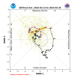
As been touted….The RMM phase space has the MJO now over the Tropical West PAC in Phase 7. Further eastward movement is expected while weakening… The Dweebs expect retrogression the Eastern Pacific High next week due to the MJO in Phase 7/8. This means that storms that are now tracking from the NNW will retrograde, with the upper jet coming in from the Pacific as early as Tuesday night or Wednesday. Further retrogression is expected later next week for wetter storms….Stay tuned….
Dr Howard and the Dweebs……………………:-)
________________________________________________________________________________________________________________________________________________________________________________
2/14/2023
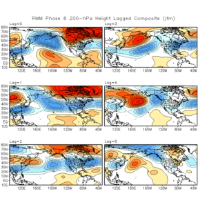
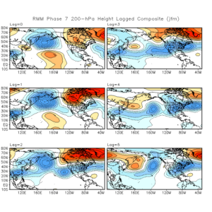
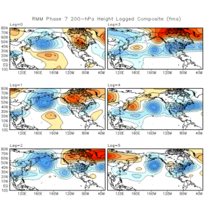
Its the middle of February and we continue to be in this cold, drier than normal pattern. That looks to change the last week of February. The MJO is going into a favored phase space for retrogression of the Eastern Pacific Ridge; Phase Space’s 7/8. I have attached that RMM chart for everyone’s perusal. More often than not in the Winter, the MJO over the western central pacific causes wet weather for CA with an increase of subtropical moisture enhancement. Were going into the same area with the MJO that we were in, the first half of January when we had all that wet weather. So it will be interesting if history repeats itself to some extent. The forcing with this pattern is expected as early as the 21st but is better later in the month and into early March.
In the meantime, Its cold! We had our highs today at 7:30AM and temps fell some eight degrees in town between 7:30AM and 8:00AM. The Arctic Ribbon pushed through our area about 8:00AM and you can see by the 700MB temp charts, temps going from -9C to -14C by 10:00AM. During this push, the Bishop Airport had a temperature of 41 degrees at 6:30AM which dropped to 32 by 9:00AM. Wind gusts increased to 60MPH at 8:00AM. There are wind advisories for the Owens Valley for strong north winds all day and into the night.
Its been snowing lightly in Mammoth this AM. It was 16 degrees at 10:00AM in town. Highs today will probably remain below 20 degrees today. The coldest air with this CPK air mass will be into our area about midnight tonight with (10,000ft) 700MB temps -17C. There will be light snowfall accumulations today. Expect moderating temps this weekend with mid 30s on Saturday up to the low 40s by Presidents Day Monday.
Look At the RMM chart below. Phases 7/8 is retrogression of the Eastern Pacific Ridge west of 140W during the last week of this month. More Moderate to Heavy Snowfall?
________________________________________________________________________________________________________________________________________________________________________________________________________________________
The colder than normal pattern we are curranty experiencing is highlighted by a weather system (Short Wave) about every 3 days. The upper ridge that governs the trajectory of the storm track is located over the North Eastern Pacific between 145 to 140 West. This position directs short waves down the West Coast or through the Great Basin. In that the coastal systems are moving mainly North to South, they lack any significant vertical motion fields for the Eastern Sierra. Any precipitation is usually deformation driven and confined to the western slopes. Any snowfall for Mammoth is usually in the light category with this pattern.
The systems that drop down through the Great Basin are picking up Arctic Air over the NW Territories’ of Canada. This cold air is modified somewhat as it moves through the Pacific NW and Great Basin. This Continental Air {CPK) will travel SE to Nevada, Monday night into Tuesday. This will affect the Eastern Slopes with very cold temps, and strong winds Monday night over the crest. CPK by nature is a dry airmass, however, can still provide some light upslope snowfall here in Mammoth Lakes. The CPK airmass is progged with -18C temps at (700MB )10,000 feet) here locally this Tuesday morning, for high temps in the lower 20s in town Tuesday (Valentines day). Lows in town Tuesday AM and Wednesday AM in the single digits. The Dweebs call this “Three Dog Night” sleeping weather!
The following system Friday the 17th is progged to be too far west for any significant snowfall as it heads south, for our high country. Then another very cold system with (CPK) air is progged for the Great Basin and California Monday the 20th. Of note, the systems that drop into the Great Basin, are not only much colder, but have more potential for stronger North Winds, sooner for the Sierra Crest, then for the Owens Valley about a day later.
The current pattern in not likely to change before the last week of the month. Thereafter, the longer range models are hinting at Retrogression of the Eastern Pacific Ridge during the last week of the month for a greater chance of significant snow producing storms, anytime from the last week of February into the first week of March.
As usual stay tuned, as models are not perfect…..Just forgiven!
Dr Howard and the Dweebs……………..:-)


