Brought to you by Howard Sheckter
Archive for March, 2023

Bi-Generational Mammoth Pass Record close to be broken….1983 record has stood for 40 years……AR winding down as coast to coast upper East Asian Jet no more….Still….Several storms will bring more snowfall to the high county through months end……
Tuesday March 14, 2023
10:30AM 3-16-2023 PS Double click on the title to get formatted discussion
Its Mid March, the Sun is higher in the sky. The days are longer, but Winter is still hanging on! After a couple of Atmospheric Rivers, it appears that we are going to get one more Monday night and Tuesday. The storm that is coming in next week is digging a bit more west and slowing. The AR train still intact will lift a bit more to the north and get Central CA. Some 6 to 7 inches of water is forecasted to the west side of Mammoth. So, another 5 inches of water is possible for Mammoth Mt from this storm by Wednesday. It is colder as we are getting more of the forcing into CA instead of it being parked to the north of us while the AR’s hang into the state.
So this will be a major snowstorm, much like we had in February. 3 to 5 feet of snow is very possible. The odds of another AR is very much much lower with the next short wave over the following weekend as the wave train of the southern jet really contracts and the system is much faster moving. As said in an earlier discussion. You cannot trust March forecast models like February and January!
PS the following system that weekend looks to bring a foot or two at this time.
PS It can not be over stated to shovel your roof if it has not been shoveled recently!!
Roofs are cracking and collapsing in Mammoth.
Dr Howard and the Dweebs………………:-)
8:00AM 3-16-23
Note:
Scripps just came out with a level 3 AR for next weeks storm. Obviously they Feel that the AR over Southern CA will lift North a bit. More after 9:00AM
3/16/23 7:30AM
East Asian Jet Retreat is well under way preventing any further ARs’s from hitting CA. A good cold storm with a good subtropical tap will hit the High Country Monday Night and bring heavy snowfall Tuesday into Tuesday night. Snow to water ratios will be at least 10:1 again. Upper mountain in for another 5 feet by Wednesday AM. The MJO has moved into Phase 1 and will shortly be into phase 2. This will transit pattern to move of an inside slider pattern by months end which is a colder dryer pattern with light snowfall as we move into April.
There is at least one more storm after the Tuesday system. So a storm that following weekend may dump another foot or two. Winter is winding down…….Springs arrives next week!
Get plenty of photos of Mammoth Mts upper mountain next week with a greater snowpack on it than ever before!!!
PS
Some one has to get the “I survived the Mammoth Winter of 2023” going!
Dr Howard and the Dweebs………………….:-)
___________________________________________________________________________________________________________________________________________________________________________________________
3/15/2023
I. Note:
Scripps has NOT issued an advisory for an Atmospheric River for the Monday/Wednesday Storm.
The Storm has a good subtropical tap but not qualified for a moderate or strong AR. However, the storm is colder and that will be good for a high quality snowfall producer. 3 to 5 feet is possible during for the Monday Night though Wednesday storm. Another storm over that following weekend may dump another 1 to 2 feet.
A quick update is to post a few new charts.
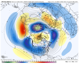
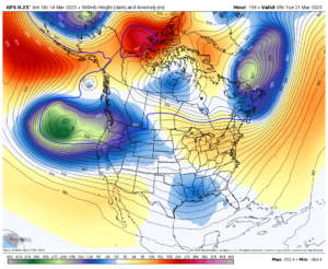
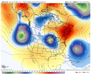
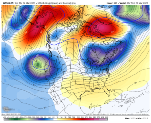
- The new 12Z GFS 500MB Means for the next 10 days is attached below. The big message here is that these storms are highly susceptible to changes now, due to the fact that they are closed lows and because of the change in the season. Closed lows often have a mind of their own and can change direction with quick notice. This means that the models can bust much easier, just a day or two ahead. We are moving into the second half of March and models are not as accurate as they were, like in February or January.
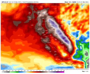
Based upon today’s 5:00AM run for QPF, another 15 inches is possible to the west of Mammoth Mt. This most likely will be much less. Will look at it again in a few days…..
The next storm timing is, Monday afternoon the 20th into Wednesday AM the 22nd. Then other system Friday night the 24th through Sunday 26th.
The storms will trend colder, as most have a more NW/SE trajectory like the ones we had in February.
_______________________________________________________________________________________________________________________________________________________________________________________________________
3-14-2023
1983 was the year Mammoth Pass tallied 90 inches of water. 1983 was a very wet year but did not have nearly the snowfall that 2023. 2023 was a much colder year.
DWP updated their Snow Survey today the 14th of March. It indicated 87.1 inches of water on the pass and 204% of normal for April 1st. Bishop has 13.16 inches and is 211% of normal now for September 30th, the end of the water year.
Mammoth still has 17+ days to tie or break the all time record.
Weather Outlook:
Weather pattern out over the pacific is looking a lot weaker over the next few weeks as compared to a couple of weeks ago. Days are getting longer quickly now, and with the longer days and more sunlight reaching the higher latitudes, the amount of cold for storms is certainly diminishing. Although there are still storms that will affect the high country over the next several weeks….The scale and size of these systems pale compared to what was observed just a few weeks ago.
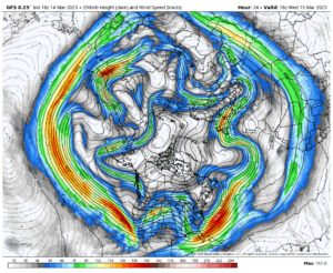
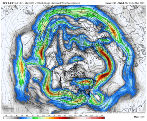
Check out the Hemi Upper Jet Map from Asia extending to our West Coast over the next two weeks. What a change in strength! Note how much it weakens! There are storms but they are almost more localized as compared to just a few weeks ago!
There is still plenty of weather systems to break the Bi Generational water year of 1983.
The following weather systems have the potential to drop anywhere between 1 to 3 feet of snowfall to Mammoth Lakes. Of course these are progs, and as such, are subject to change, especially in Spring, in the week two period.
I’ll post a few weather proggs of storms, with that potential….
