Brought to you by Howard Sheckter
Near Record Cold Over the Weekend supplying wind energy for the Southland today……Next shot of Great Basin energy on the way……
Monday October 28, 2019
November 1st;
The weather pattern continues dry for the eastern sierra. Stronger inversions are developing now and so temperatures aloft are not as cold. There are two global models that I usually compare most of the time. The ECMWF (euro) The GFS (american) On occasion, the JMAN Japanese (ensemble) and Canadian. (GEM)
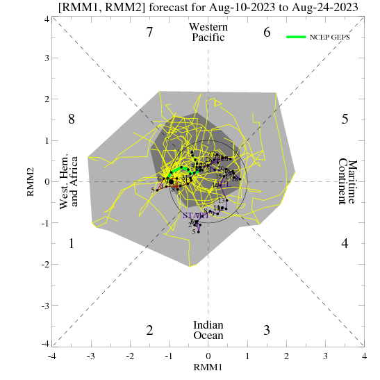
All are dryer than normal for November, The November outlook is arriving soon. The big issue here I think is the ongoing strong IOD Indian Ocean Dipole in its positive phase. It is responsible for below normal convection over the Maritime Continent to the Western Pacific. This often times will shift the tropical convection over the Western Hemi further east and as a result, teleconnection often favor a Trof in the east and ridge in the west. Not all the time, but often enough to make a difference in normal amounts of precipitation over CA. The +IOD will most likely weaken toward the end of the Winter. The European model is an air-sea coupled model and may have a better handle on the longer range this winter as compared to the GFS. We’ll see…. At the moment, the GFS has the MJO into phase 8-1 around mid month. That would be positive for a storm or two for Mammoth. Those MJO Phases often pulls the upper, Eastern Pacific high far enough north to allow some undercutting of the westerlies to the west coast. However, the ECMWF does not get it there….Thus it continues to be drier than normal through mid month. The climate model portion of the ECMWF shows a few feet of snow for Mammoth as we go from Mid Month to the end of the month. The Dweebs will keep you all in the loop on this.
Dr Howard and the Dweebs…………………..:-)
________________________________________________________________________________________________________________________________________________________________________________________________________________________________________________________________
Mammoth Residents had a rude awaiting Sunday morning as the low temperatures of the early morning did not change all that much during the afternoon. Mammoth even experienced some light snow flurry action for a time. Mammoth’s high temperature was confined to the mid 20’s on Sunday while in Bishop Ca, the high temperature nearly broke a record high-low of 49. This was a degree above the all time record High -Low set back in 1991 for the date. In Mammoth Lakes, the high was 26 degrees, possibly a record, High-Low?
The wave that pulled through Sunday morning pulled Northern Rockies cold air into our area. In back of the upper Trof and surface front, high pressure at the surface built in, and was accompanied by strong subsidence aloft. Then forced down sloping winds to the west of the Sierra and south to the mountains, east of LA created fire storm conditions to those regions.
Gradients will begin to relax today and into tonight for the high country. However, another dry cold dynamic system will push into the Sierra Tuesday, and build pressures at the surface Tuesday night into Wednesday for another Offshore Wind event, and this time, possibly on steroids for the south. The upper jet appears to be stronger with this system for Tuesday with stronger convergence aloft in the Right Front Quad of the upper jet. Once again, this is a dry system.
This looks to be the last of the Santana wind events for a while. Hopefully the last, even if that’s wishful thinking….
As far as a real snow storm for Mammoth?…..We’ll have to see what mother nature deals out for us for the middle of November…..
Dr Howard and the Dweebs…………………..:-)
PS….
Looking at the GFS Ensemble for the MJO, there is an interesting curiosity developing in the MJO RIM with 1.5 Sigma in phases 1/8.
This is the time frame during the 2nd week of November. The MJO Lagg composites suggest at least weak west coast troughing during this period in November.
This is just something to watch…….


