Brought to you by Howard Sheckter
Closed low now formed will drop SSE today then move into Southern CA Saturday…..Light snowfall expected….Mainly Saturday for Mono County…..This will be followed by another dry week…..
Thursday February 20, 2020
February 25th
Of Public interest;
The driest winters with less than 225 inches
- 2007 222 inches
- 1990 214
- 1977 197.5 inches
- 1987 195.8
- 2015 176
- 1977 94
Winter of 2020 so far 138 with March, April and May to go.
What’s different between most of these winters and the winter of 2020?
- We have arguably the best snow making system in the Sierra
- We have the best snow grooming system in place in the country!
Next weather system Saturday night and Sunday…..
________________________________________________________________________________________________________________________________________________________________________________________________________________________________________________
February 23rd 2:30PM
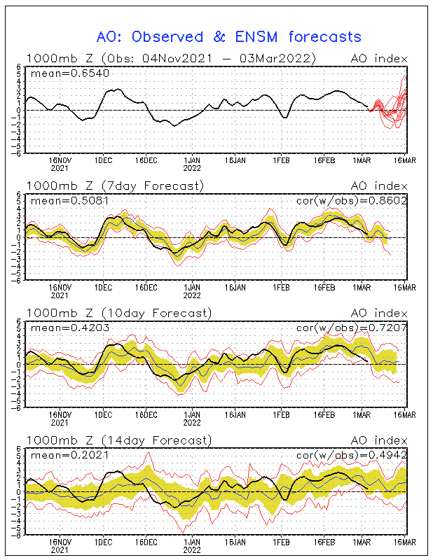
Well folks we got a true dusting with .01 inches of precip! Wow! The rest of this week up to Saturday will be dry as well, with a slight chance of some snowfall next Sunday……Meteorological Winter will go out like a Bambi. Keep your fingers crossed about March. We could still get a few good weather systems next month, however, if the AO stays strongly positive, the chances of a Miracle March would be just that…….A Miracle!
The Weather Forecast this week shows that temperatures will warm some 10 and 15 degrees above normal by Wednesday. High temps will climb to the mid 50s by Wednesday; lows between 25 and 30. Expect lots of high clouds the second half of the week. It will be dry through Saturday.
(Blame it on the +AO)
It has been determined that the cause of this dry winter out west was primarily due to a very intense positive phase of the Arctic Oscillation, where-by record low pressure aloft set up over the Arctic, keeping much of the Arctic Air confined to the Arctic. This phase does not allow much Frigid Air to pour south, out over the North pacific in our case. For example, Fairbanks Alaska is having one of the coldest winters in decades.
In this phase of the Arctic Oscillation, the standard deviations from normal have been determined to be modern day historic!
With strong low pressure aloft, 500MB-1000MB thickness over the Arctic have lead to one of the coldest Arctic Winters in decades. This may have had an affect of increasing the Arctic Sea ice and hopefully giving the Polar Bears some kind of a break?
Over the next few days, more record +AO indices are expected. 
_________________________________________________________________________________________________________________________________________________________________________________________________________________________
Finally…a little light snowfall is expected for this Saturday. Nothing major, but with a little luck, some 2 to 4 inches may fall on Mammoth Mt. The change in the forecast is due to a change in the track of this small cut off low pressure system, as it moves through Southern California a bit further north. There is no cold air advection with this system for Mammoth. The precipitation will mainly be up-slope snow Saturday. Some 1 to 4 inches is expected for The Town of Mammoth and Mammoth Mt. It will be dry and cool on Sunday. Highs will be in the low 40s in town Saturday with lows in the 20s….
The extended outlook shows a progressive pattern with the upper ridge off shore building into California, early to mid week for above normal temps by Wednesday. The next system that is expected to bring some light snowfall is expected to follow a similar track into Southern CA on the 4th of March…. However, we are expecting a change in the pattern over North America during that time. So the weather outlook may change for the 1st week of March….
Of note, this ski season has brought 138 inches of snow at the Main Lodge. There have only been 3 winters historically in the past 50 years with under 200 inches by May 31st. That means that if we only get another 5 feet over the next 2.3 months, that would qualify for the 4th driest winter in the past 50 years….Is that likely? No….As the odds based upon climatology are well against it….However, the odds are rapidly increasing that this will go down as one of the “drier than normal years” for the Central Sierra….
The Dweeber…………………….:-)


