Brought to you by Howard Sheckter
Mammoth Weather Outlook

Fair and Dry through Weeks End with slightly above normal temperature’s. A Monsoon Surge is expected early to middle of next week….
Thursday July 21, 2022
08/01/2022
At the moment, on the 850MB/ 250MB Lower Convergence/Upper Divergence couplet is developing West of Bishop over the Sierra then NE into Southern Mono County. Should be a very active day especially NE of that area.
Flash flood watch for Owens Valley Through 10:00pm TONIGHT.
Thunderstorms bringing Heavy rain are possible for many areas of Mono and Inyo County today and tonight.
Mammoth Lakes picked up .26 of and inch yesterday.
Highs in the low to mid 70s today lows in the 50s
There will be at least a chance of rain each afternoon this week.
Outlook:
The main monsoonal ridge will continue to push to the west and will be centered near the AZ border by Tuesday PM. By Thursday, the ridge will lift to the north and be centered near the 4 corners area, which will provide another opening of the door for a return of deeper monsoonal flow. Therefore, an uptick on thunderstorm coverage is expected through Saturday. Temperatures will trend upwards midweek before cooling Friday again.
7/30/22022
The upper high that has been parked over Northern CA/NV will shift east over Utah by Sunday allowing a broad southeast to southerly flow, advecting moisture across our area tomorrow Sunday and Monday. An easterly wave now located over Extreme Southern CA will migrate NW through Sunday providing dynamics and both surface convergence and upper divergence through the Owens Valley and especially Southern Mono County. Outflow boundaries from storms from the afternoon will be the focus for newly formed thunderstorms into Sunday night. PWAT is approaching an inch over the southern portion of Mono County by late afternoon. Heavy Rain with frequent lightning is possible as the day rolls on. Campers and Hiker should be mindful not travel and camp near creeks, streams or rivers Sunday and Monday. Although Flash Flooding is some what rare in the sierra because of the watershed, The White Mts adjacent to the Owens Valley is very susceptible to FF’s. The upcoming pattern for Sunday and Monday looks pretty intense for locally Heavy Rain throughout Northern Inyo and Mono Counties. Drier weather will return by Mid Week.
High temps will climb into the low 80s today but cool to the low 70s by Monday. Lows in the 40s are expected early next week. A warming trend set in Next Thursday.
Dr Howard and the Dweebs……………………..:-)
7/22/22 Update:
Big Pattern change this weekend over the Hemisphere as the upper low over AK retrogrades west while strong height rises occur into the GOA. This in turn will tug the Continental High over the desert SW West/North Westward, leading to a significant negative tilt continental high creating very good Monsoonal flow into Nevada and California beginning next week and beyond. Once the upper flow gets established, next to watch for is areas of dynamic lift! Stay Tuned!!! It could get pretty wet at some point later next week….
The Dweeber………………:-)
________________________________________________________________________________________________________________________________________________________________________________________________
WX Discussion:
A shift in the upper level winds from the SW on Wednesday due to weak troughing has scoured out what monsoon moisture there was yesterday. Our air mass will remain dry now through Monday with little change in temperatures. The fact that lightning will not be an issue, our air quality should remain clean as well. High temperatures will remain above normal the next 5 days. However, a bit enhanced Zephier wind will provide breezy weather in the afternoons and evening to flush any hot air out of buildings with windows open! Our WX is just perfecto!
___________________________________________________________________________________________________________________________________________________________________________________________________
It been hot and will stay hot over the Owens Valley with little change in temperatures expected through next Tuesday. High temps will range between 100 and 105 and lows in the 60s in the north and 70s in the central and south. Winds will be light as well. Swamp Coolers work well in this pattern. However, as moisture increases later next week, it will become more humid and thus more challenging for those cooling systems by Wednesday or Thursday.
In the high country of Mono County, high temperature’s have been in the low 80s and will stay there through weeks end, with lows in the low 50s. Although it will be quite warm to hot over our region, no high temperature records are expected to be broken.
OUTLOOK:
Next week another surge of Monsoon Moisture will occur, beginning Tuesday and especially Wednesday and Thursday. This SE flow is likely to continue for at least a week or longer. This is the period of time, not only Meteorologically but Climatologically that we will have our next best chance of wetting rains and Thunderstorms. Any heavy rains and or flooding will be dependent upon any dynamics/focusing mechanisms which may accompany. (So stay tuned on that) The Dweebs will update later this weekend or sooner if necessary.
ENSO:
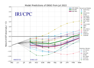
The updated IRI graphs shows high confidence that La Nina will continue through the Fall, then transitioning to ENSO Neutral during JAN, Feb March 2023. La Nina Winters in Central and especially Southern CA, has a dry bias. However, as we know from last December, it can be wet too. An ENSO Neutral Signal for Winter 2023 might suggest that the winter months of 2023 could be surprising wet for CA. Why? The highest frequency of Atmospheric Rivers (AR’s) along the west coast occur during periods when SSTAs in the ENSO region 3.4 are between -05C and +05C. Just something to think about. 🙂
Dr Howard and the Dweebs………………………….:-)


