Brought to you by Howard Sheckter
Mammoth Weather Outlook

West Coast Ridge is favored to remain in control this week…..MJO moving back over Indian Ocean has good chance of initiating Pattern Change to -PNA for the far west……
Wednesday December 27, 2017
12-28-17 8:40AM
Quick update this morning shows upper west coast ridge holding strong through New Years Day. However confidence is high for the retrogression of the ridge during the 2nd week of January. A strong interseasonal signal points toward an increase in convection off the coast of Africa and east into the Indian Ocean as the MJO is currently redeveloping in that area as per IR Sat maps. SEE: http://tropic.ssec.wisc.edu/real-time/imagemain.php?&basin=indian&prod=irbbm&sat=m5
Here is another update on the MJO and its forecasted intensity: This is the RIMM (Phase space) from the European 00z Thursday forecast run from last night. It clearly shows an intensification of the signal and a progression from where it is currently emerging, just over the western Indian Ocean. http://www.cpc.noaa.gov/products/precip/CWlink/MJO/CLIVAR/ecmf.shtml
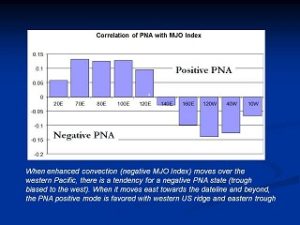
MJO’S convective envelope is just moving into the 40E area. Based upon the RIMM forecasts, intensification of tropical convection is expected in the coming days as the MJO either stalls out over the Indian Ocean or is progressive into the Maritime Continent. This interseasonal signal often times affects the western Northern American PNA teleconnection which in its current phase is positive, to one that may become negative. -(PNA) The hope is that the west coast ridge associated with the +(PNA) flips negative and a long wave trof sets up.
Note: There is usually a delay in the flip in the PNA signal until the MJO reaches the Maritime Continent or even the western pacific.
(Note the chart below)
The long-range guidance (Week 2) is responding, however, the timing and how the pattern change all unfolds is uncertain at this point. Timing is between the weekend of the 6th and Mid Month. Although this mornings runs of the global models suggests that the pattern change will be slower, it could be quicker as well. That is just an unknown.
Other climate signal’s and other thoughts:
For two weeks straight now the SOI has flipped on a daily basis to become negative, meaning that the trades have weakened significantly. This maybe due to an air-sea coupled Kelvin Wave or ?? Its affects are tearing the La Nina apart and will weaken it rapidly as we go into the spring. Once the ENSO signal crosses into LA Nada, if it happens early enough this Winter/Spring, we may begin to see “Atmospheric Rivers” return to the west coast again.
It is interesting or possibly coincidental that the MJO is moving through the Indian ocean and intensifying, while the SOI has become negative for an extended period of time……
Will this MJO or another following this Winter/Spring, be the catalyst for the Next El Nino?…..
The Dweeber………………….:-)
____________________________________________________________________________________________________________________________________________________________
10:45AM:
The new 12/27/17 12Z GFS is now singing the same tune of a pattern change the end of week 2. (The Weekend of January 6th into Mid Month)
This is the best MJO signal I have seen this year.
Keep your fingers crossed….:-)
The Dweebs have been watchin and waiting for confirmation of a pattern change forecasted by the European Model for sometime in early to mid January…..The GFS American Models has not been in agreement. So the questions arises, which model is correct? Although at this point there is no certainty, if the Dweebs use other climate forecasting tools such as the MJO in conjunction with the other global models, such as the Canadian and Japanese models, there appears to be more censuses that a strengthening signal will develop over the Indian Ocean over the RIMM phases 2 and 3:
SEE: * http://www.cpc.noaa.gov/products/precip/CWlink/MJO/CLIVAR/clivar_wh.shtml One can derive a bit of bias because of global models such as the CMET, JMAN as well as the EMOM. All are pointing toward a strengthening signal over the Indian Ocean. A strengthening signal in that area foretells a flip in the PNA teleconnection from the current positive mode to negative. A negatives sign PNA is associated with troughing instead of the current ridging we currently have over the far west.
*Dynamical model MJO index forecasts quite consistently show a re-amplification of the MJO signal as it enters the Indian Ocean, moving away from peak destructive interference with the La Nina signal. Should this occur, Indian Ocean MJO events teleconnect well with the North American mid-latitude circulation, and the MJO may therefore help effect a pattern change in the late Week-2 or Week-3/4 period.


