Brought to you by Howard Sheckter
Last few Days of Winter Pretty Uneventful…..Windy and cooler Today then Lighter Breezes through Tuesday…..Seasonal Temps expected From Wednesday through the weekend…..Next Chance of a storm the middle of next week…El Nino Beats On………
Monday March 17, 2014
Few Changes Today Wed…..
Although it will be warmer today, there is a weak wave that will come through Friday/Night that might kick off some showers in the afternoon. Limited moisture and forcing will produce mostly cloudiness though, as there is not much upper jet support as well. ECMWF still has a good system forecasted for mid week, next week for the Sierra. It may slow down a bit, but should get here, and there are others behind It. The MJO moving a bit east well into the Indian ocean should allow a better -PNA pattern to develop; and so favor the ECMWF over the GFS at this time, especially that latter part of the month and into April. Highs in the low 50s now with lows in the 20s
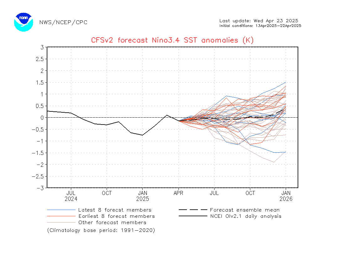
More on the Kelvin Wave over the West Central, that is appearing to be epic. The latest CFS v2 output issued the first day of spring showed from the last 10 days of monitoring, the Nino 3.4 region reaching the strong threshold by the end of October. It will be interesting to follow to see if it holds… SEE: http://origin.cpc.ncep.noaa.gov/products/people/wwang/cfsv2fcst/imagesInd3/nino34Mon.gif
Also, there will have to be at least one more Kelvin Wave develop this Summer to be strong and travel east to keep up the momentum of down welling to keep of the momentum into the following early winter.
For the more advanced hobbyist…..see: http://www.cpc.ncep.noaa.gov/products/precip/CWlink/ghazards/ARCHIVE/BRIEFING/telecon_20140318.pdf
DR Howard and the Dweebs…………………………..:-)
Tuesday Update:
Forecast on track for a cooler day today with highs in the mid 40s….Next possible system to bring precip middle of next week…………………
On the Subject of Kelvin Waves and El Nino, I am passing on a link to an article by the Weather Centre, that I have found to be very interesting……Thanks to one of my followers for passing it on to me.
I did not realize the magnitude of the current Kelvin Wave, now moving across the Western and Central pacific………
See: http://theweathercentre.blogspot.com/2014/03/could-next-super-el-nino-be-forming.html
———————————————————————————————————————————————————————–
A NW Slider in process is bringing the Northern Rockies more Winter the next few days while the Eastern Sierra experiences more wind. High temps will cool to seasonal levels today with a high near 50 with WNW winds in town gusts 30 to 45 MPH. Expect about 5 degrees of additional cooling Tuesday with temps in the mid 40s with light north breezes. Tuesday will be the coolest day of the new week. Thereafter, high temps will average in the low 50s the remainder of the week. Lows in the teens and 20s then mostly 20s the 2nd half of the week.
Taking a look at the GFS days+ 3, 5, 8 and 11; It is evident that, the current north-west slider is a product of the eastern pacific ridge with modest amplitude, at about 145west. A change in the pattern that was suggested last week still looks good with the formation of the -EPO just after mid-week. This is a pattern of a blocking ridge over AK coupled with a developing stationary upper low beneath it at about 145 West. it is indicated that the lower portion of that block will slowly progress east, setting up a deep enough Trof over the eastern pacific to get us a storm or two the following week. (ABOUT MID WEEK) (Tuesday-Wednesday+) Thereafter, it is also suggested that this long wave will possibly persist into Early April for further unsettled WX. At the moment, the storminess next week may produce a foot to a foot and a half according to the CFS V2. (Will update later this week on the QPF)
Although Winter officially ends astronomically at 9:57 AM March 20th PDT, Meteorological winter ended over 17 days ago as we began the month of March.
This mornings run of the CFS for April shows most of the precipitation for the month of April to occur within the first half. It is suggesting an adjusted 1 to 1.25 inches of QPF within that time frame……..
ENSO:
The Prospect for a significant EL Nino for next winter still look good at this time: SEE: http://www.cpc.ncep.noaa.gov/products/people/wwang/cfsv2fcst/imagesInd3/nino34Mon.gif
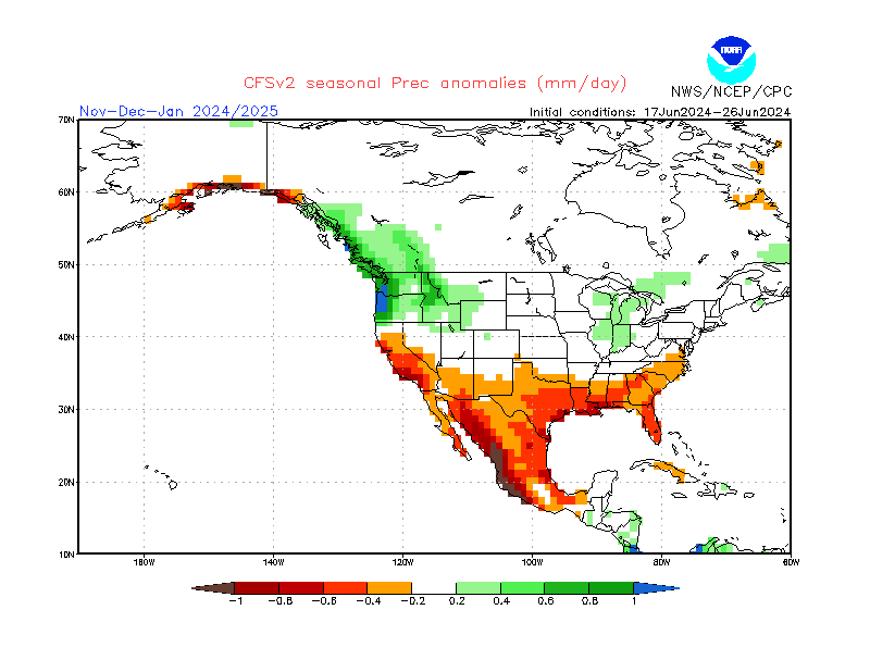
Most likely, the CFS system’s rainfall outlook for our Summer is a reflection of that. SEE: http://www.cpc.ncep.noaa.gov/products/people/wwang/cfsv2fcst/imagesInd3/usPrecSeaInd5.gif
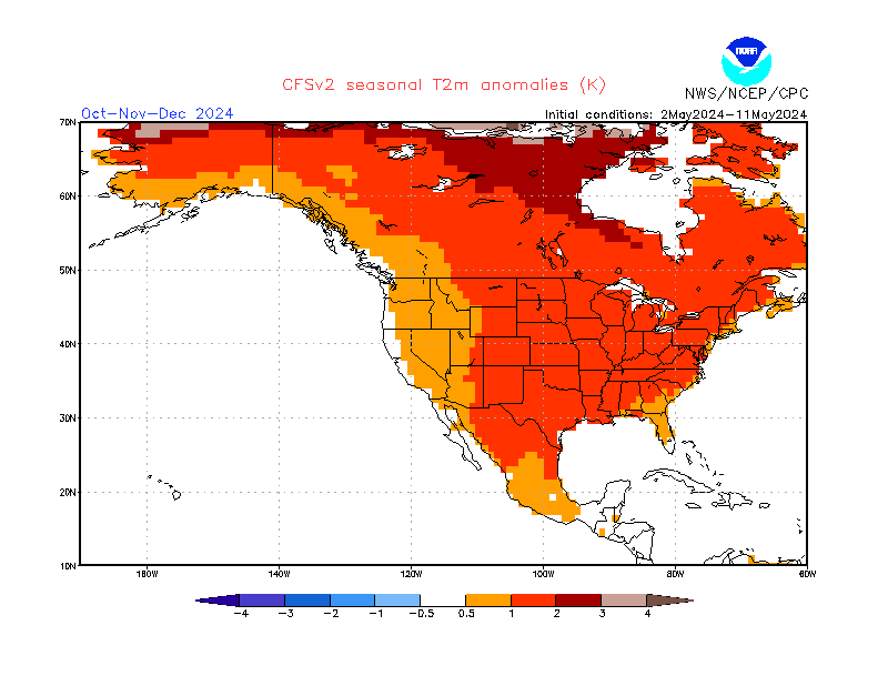
As well as warmer than normal temperatures: SEE: http://www.cpc.ncep.noaa.gov/products/people/wwang/cfsv2fcst/imagesInd3/usT2mSeaInd5.gif
On the Brightside….The forest could sure use the rain…..
On the Negative side, historically, we get more high based storms in the Summer here, and thus what may happen is that we’ll have a higher incidence of Lighting in the forest.
During this late Spring and early Summer, it will be most important that locals do what ever they can to:
1. Clear to the legal limits, small trees under the canopy near their residences.
2. Trim all snow branch’s of large trees over hanging your home. Remove small dead trees.
3. Clear a safe buffer of pine needles away from your home. Last summer we dodged a bullet
(The upcoming fire season could be Epic! Be Prepared and Safe!!!)
The Dweeber…………………………:-)


